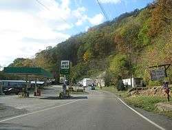
Whitewood, Virginia
| Whitewood | |
|---|---|
| Unincorporated community | |
 Whitewood, Va. | |
 Whitewood Location within the Commonwealth of Virginia  Whitewood Whitewood (the US) | |
| Coordinates: 37°14′08″N 81°51′25″W / 37.23556°N 81.85694°WCoordinates: 37°14′08″N 81°51′25″W / 37.23556°N 81.85694°W | |
| Country | United States |
| State | Virginia |
| County | Buchanan |
| Population (2000) | |
| • Total | 485 |
| Time zone | UTC−5 (Eastern (EST)) |
| • Summer (DST) | UTC−4 (EDT) |
| ZIP codes | 24657 |
| Area code(s) | (276) |
Whitewood is an unincorporated community in Buchanan County, Virginia. As of the 2000 census, the Whitewood area had a population of 485.[1] It is located along the Dismal River, which is part of the watershed of the Big Sandy River.
History
The community was initially settled in the early 1900s by lumber companies that arrived to log the forests of the surrounding hills. The settlement was named Whitewood, supposedly after the color of the lumber, shortly after the first lumber mill was established in 1905.[2] The Whitewood post office was established in 1906.[3]
In September 2008, Whitewood High School, built in 1940, was placed on the National Register of Historic Places.[4] It was demolished in early 2010.
Education
Public High Schools
Notable person
- Ruth White, author.
References
- ↑ "American FactFinder". United States Census Bureau. Retrieved on 2008-10-11
- ↑ Baker, Nancy Virginia. Bountiful and beautiful: a bicentennial history of Buchanan County, Virginia. Printed at the Buchanan County Vocational School, 1976.
- ↑ "Buchanan County". Jim Forte Postal History. Retrieved 28 September 2014.
- ↑ National Register of Historic Places Weekly List, September 19, 2008.
Municipalities and communities of Buchanan County, Virginia, United States | ||
|---|---|---|
| Town | 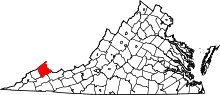 | |
| CDP | ||
| Unincorporated communities |
| |
| Footnotes | ‡This populated place also has portions in an adjacent county or counties | |
This article is issued from
Wikipedia.
The text is licensed under Creative Commons - Attribution - Sharealike.
Additional terms may apply for the media files.