Pathfork, Kentucky
| Pathfork, Kentucky | |
|---|---|
| Census-designated place | |
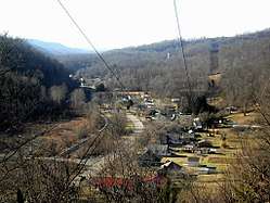 View of eastern Pathfork above one of the mountains | |
 Pathfork  Pathfork | |
| Coordinates: 36°45′21″N 83°27′53″W / 36.75583°N 83.46472°WCoordinates: 36°45′21″N 83°27′53″W / 36.75583°N 83.46472°W | |
| Country | United States |
| State | Kentucky |
| County | Harlan |
| Area[1] | |
| • Total | 1.253 sq mi (3.25 km2) |
| • Land | 1.243 sq mi (3.22 km2) |
| • Water | 0.010 sq mi (0.03 km2) |
| Elevation | 1,240 ft (380 m) |
| Population (2010)[2] | |
| • Total | 379 |
| • Density | 300/sq mi (120/km2) |
| Time zone | UTC-5 (Eastern (EST)) |
| • Summer (DST) | UTC-4 (EDT) |
| ZIP code | 40863 |
| Area code(s) | 606 |
| GNIS feature ID | 489796[3] |
Pathfork is an unincorporated community and census-designated place (CDP) in Harlan County, Kentucky, United States, located to the south bank of Wallins Creek. Its population was 379 as of the 2010 census.[2] The city's main roads are East Hwy 72, which connects from US 119, and travels to an end at Old RB Mines, however, 72 runs to Harlan via gravel road,and Ky 2005 an old gravel road that leads to Smith/Brownies Creek, south of Harlan, Kentucky.
Overview
The town used to rely heavily on coal mining. But many coal mines now have been shut down causing a reduction in the production of coal. The recent recession in the coal market brought about by over regulation of the E.P.A., has caused high unemployment rates in this small town as well as Harlan County, Kentucky and throughout the United States. A small community park, known as Coal Miner's Memorial Park, was created to honor the community's ties to coal mining.
There are four churches in the town: Insull Holiness, Pathfork Holiness Church, Pathfork Baptist and Blackstar Pentecostal Church.
References
- ↑ "US Gazetteer files: 2010, 2000, and 1990". United States Census Bureau. 2011-02-12. Retrieved 2011-04-23.
- 1 2 "American FactFinder". United States Census Bureau. Archived from the original on September 11, 2013. Retrieved 2011-05-14.
- ↑ "Coldiron". Geographic Names Information System. United States Geological Survey.