Mary Helen, Kentucky
| Mary Helen, Kentucky | |
|---|---|
| Unincorporated community | |
 Mary Helen  Mary Helen | |
| Coordinates: 36°48′46″N 83°15′18″W / 36.81278°N 83.25500°WCoordinates: 36°48′46″N 83°15′18″W / 36.81278°N 83.25500°W | |
| Country | United States |
| State | Kentucky |
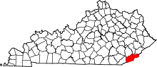
| County | Harlan |
| Elevation | 1,358 ft (414 m) |
| Time zone | UTC-6 (Central (CST)) |
| • Summer (DST) | UTC-5 (CST) |
| ZIP code | 40818[1] |
| GNIS feature ID | 497642[2] |
Mary Helen (also known as Coalgood[3]) is an unincorporated community in Harlan County, Kentucky, United States.
References
- ↑ United States Postal Service. "USPS - Look Up a ZIP Code". Retrieved April 9, 2017.
- ↑ U.S. Geological Survey Geographic Names Information System: Mary Helen, Kentucky
- ↑ Rennick, Robert M. (August 28, 2013). Kentucky Place Names. University Press of Kentucky. ISBN 9780813144016.
This article is issued from
Wikipedia.
The text is licensed under Creative Commons - Attribution - Sharealike.
Additional terms may apply for the media files.