Ages, Kentucky
| Ages, Kentucky | |
|---|---|
| Census-designated place | |
 Ages  Ages | |
| Coordinates: 36°51′28″N 83°14′47″W / 36.85778°N 83.24639°WCoordinates: 36°51′28″N 83°14′47″W / 36.85778°N 83.24639°W | |
| Country | United States |
| State | Kentucky |
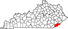
| County | Harlan |
| Elevation | 1,325 ft (404 m) |
| Time zone | UTC-6 (Central (CST)) |
| • Summer (DST) | UTC-5 (CST) |
| ZIP code | 40801 |
| FIPS code | 21-00514 |
| GNIS feature ID | 485792[1] |
Ages is an unincorporated coal town and census-designated place (CDP) in Harlan County, Kentucky, United States.
History
A post office called "Ages" was established in 1892, and the post office removed to Brookside, Kentucky and its name changed to "Ages-Brookside" in 1975.[2] The community takes its name from nearby Ages Creek.[3]
The community was listed by the U.S. Census Bureau as a census-designated place in 2014. No population figures are available from the 2010 census.
Geography
Ages is located in central Harlan County in the valley of the Clover Fork of the Cumberland River. It is bordered to the west by Brookside and to the east by Verda, both unincorporated. The Clover Fork valley lies between Black Mountain to the north and Little Black Mountain to the south. Elevations in the area range from 1,245 feet (379 m) in the center of Ages, to 3,355 feet (1,023 m) on the closest summit of Black Mountain, to 3,380 feet (1,030 m) on the closest summit of Little Black Mountain. (Black Mountain continues east 20 miles (32 km) to its true summit, the highest point in Kentucky at 4,145 feet [1,263 m].)
Kentucky Route 38 is the main road through Ages, leading west down the Clover Fork valley 5 miles (8 km) to Harlan, the county seat, and east 3 miles (5 km) to Evarts.
References
- ↑ U.S. Geological Survey Geographic Names Information System: Ages, Kentucky
- ↑ "Harlan County". Jim Forte Postal History. Retrieved 17 January 2016.
- ↑ Rennick, Robert M. (28 August 2013). Kentucky Place Names. University Press of Kentucky. p. 37. ISBN 0-8131-4401-9.