Cawood, Kentucky
| Cawood, Kentucky | |
|---|---|
| Census-designated place | |
 Cawood  Cawood | |
| Coordinates: 36°47′2″N 83°13′42″W / 36.78389°N 83.22833°WCoordinates: 36°47′2″N 83°13′42″W / 36.78389°N 83.22833°W | |
| Country | United States |
| State | Kentucky |
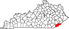
| County | Harlan |
| Area | |
| • Total | 1.5 sq mi (3.8 km2) |
| • Land | 1.5 sq mi (3.8 km2) |
| • Water | 0.0 sq mi (0.0 km2) |
| Elevation | 1,320 ft (400 m) |
| Population (2010) | |
| • Total | 731 |
| • Density | 501/sq mi (193.5/km2) |
| Time zone | UTC-6 (Central (CST)) |
| • Summer (DST) | UTC-5 (EDT) |
| ZIP code | 40815 |
| FIPS code | 21-13582 |
| GNIS feature ID | 489151[1] |
Cawood is a census-designated place (CDP) and coal town in Harlan County, Kentucky, United States. The population was 731 at the 2010 census.[2]
A post office in Cawood was established in 1890 by Wilson S. Hensley, whose ancestor is said to have been one Berry Cawood, a hero of the Revolutionary War.[3]
Geography
Cawood is in south-central Harlan County in the valley of Crummies Creek, where it joins the Martins Fork of the Cumberland River. U.S. Route 421 forms the southern edge of the community, leading northwest down the Martins Fork valley 9 miles (14 km) to Harlan, the county seat, and southeast across the Tennessee Valley Divide 14 miles (23 km) to Pennington Gap, Virginia.
According to the U.S. Census Bureau, the Cawood CDP has an area of 1.5 square miles (3.8 km2), all of it land.[2]
Demographics
As of the 2010 census there were 731 people, 292 households, and 210 families residing in the CDP.[4] The population density was 39 people per square mile (61.1/km²).[4]
References
- ↑ U.S. Geological Survey Geographic Names Information System: Cawood, Kentucky
- 1 2 "Geographic Identifiers: 2010 Demographic Profile Data (G001): Cawood CDP, Kentucky". American Factfinder. U.S. Census Bureau. Retrieved June 29, 2017.
- ↑ Rennick, Robert M. (1987). Kentucky Place Names. University Press of Kentucky. p. 53. Retrieved 2013-04-28.
- 1 2 https://www.census.gov/geo/www/gazetteer/gazetteer2010.html