Patan district
| Patan district | |
|---|---|
| district | |
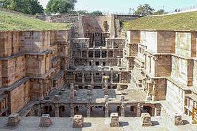 Rani ki vav in Patan | |
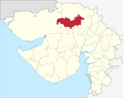 Location of district in Gujarat | |
| Country |
|
| State | Gujarat |
| Headquarters | Patan |
| Area | |
| • Total | 5,792 km2 (2,236 sq mi) |
| Population (2011) | |
| • Total | 1,343,734 |
| • Density | 230/km2 (600/sq mi) |
| Languages | |
| • Official | Gujarati, Hindi, English |
| Time zone | UTC+5:30 (IST) |
| Vehicle registration | GJ-24 |
| Website |
gujaratindia |
Patan district is one of the 33 districts of Gujarat state in western India. This district is located in northern Gujarat and bounded by Banaskantha district in the north and northeast, Mehsana district in the east and southeast, Surendranagar district in the south and Kutch District and the Kutch nu Nanu Ran (Little Rann of Kutch) in the west. The district occupies an area of 5792 km².
Some of its areas, Harij and Sami, bordering Kutch are quite sensitive as there is no settled population between there and the border of Pakistan even though geographically the border is quite some distance away.
Origin of name
The district is named after Patan, the headquarters of the district. It was one of the ancient and early medieval capitals of Gujarat, described vividly in the novels written by K.M. Munshi. Originally King Vanraj Chavda established this new city and named Anahilpur Patan OR Anhilvad Patan after the name of his very close friend and the pioneer in establishing the state of Patan, the long fought battle against the then ruler from south with help of local tribals, citizens and loyal warriors to his father The king of state Panchasara few kilometers away from Patan today. Later, a number of rulers like Bhimdev, Kumarpal, Siddharaj and Karndev ruled from Patan.
History
Patan District was formed on 2-10-97 from the parts of Mahesana and Banaskantha Districts. Patan District was formed including Patan, Siddhapur, Chanasma, Harij and Sami Talukas of Mahesana district and Radhanpur and Santalpur Talukas of Banaskantha District. The headquarter of the District is Patan. There are many Hindu temples and Jain Temple in the district.
Divisions
Patan district comprises nine Talukas:
Its headquarters is the city of Patan, Gujarat. Apart from Patan, Modhera is also an important tourist destination.
Patan itself has few good tourist spots, to attract people interested in heritage and history. Shankheshwar Jain Temple, Sahastraling Lake (A lake of thousand Lingas) and Ranakai Vav (A deep well) are very good attractions, apart from Panchasar Jain Temple, which is supposed to have lot ancient writings belonging to Jain religion.
There are nearly 150 Jain temples still in existence. Panchar Parshwanath and Shamla Parasnath are most popular Jain temples in Patan.[1]
Apart from that town of Patan has lot of facilities for medical treatment and is undoubtedly the medical centre of North Gujarat.
Demographics
According to the 2011 census Patan district has a population of 1,343,734,[2] roughly equal to the nation of Swaziland.[3] This gives it a ranking of 359th in India (out of a total of 640).[2] The district has a population density of 234 inhabitants per square kilometre (610/sq mi).[2] Its population growth rate over the decade 2001-2011 was 13.53%.[2] Patan has a sex ratio of 935 females for every 1000 males,[2] and a literacy rate of 72.30%.[2]
The district had a population of 1,182,709 (male 612,100 and female 570,609).[4]
Solar project
Gujarat Solar Park at Charanka has a solar power production capacity of 345 Megawatt. The park, on the linesate, is being further developed.
References
- ↑ https://patandp.gujarat.gov.in
- 1 2 3 4 5 6 "District Census 2011". Census2011.co.in. 2011. Retrieved 2011-09-30.
- ↑ US Directorate of Intelligence. "Country Comparison:Population". Retrieved 2011-10-01.
Swaziland 1,370,424
- ↑ India Census Archived 2012-06-19 at WebCite
2: http://www.census2011.co.in/census/district/184-patan.html
External links
Places adjacent to Patan district | |
|---|---|
| Topics | 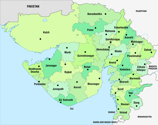 | |
|---|---|---|
| Regions of Gujarat | ||
| Districts | ||
| Major cities | ||
| Ecoregions | ||
| Economy |
| |
| ||