Palmwoods, Queensland
| Palmwoods Sunshine Coast, Queensland | |||||||||||||||
|---|---|---|---|---|---|---|---|---|---|---|---|---|---|---|---|
 Palmwoods Hotel | |||||||||||||||
 Palmwoods | |||||||||||||||
| Coordinates | 26°41′S 152°57′E / 26.683°S 152.950°ECoordinates: 26°41′S 152°57′E / 26.683°S 152.950°E | ||||||||||||||
| Population | 5,492 (2011 census)[1] | ||||||||||||||
| Postcode(s) | 4555 | ||||||||||||||
| Location | 100 km (62 mi) from Brisbane | ||||||||||||||
| LGA(s) | Sunshine Coast Region | ||||||||||||||
| State electorate(s) | |||||||||||||||
| Federal Division(s) | Fairfax | ||||||||||||||
| |||||||||||||||
Palmwoods is a town and locality in the Sunshine Coast Region, Queensland, Australia.[2][3] At the 2011 census, Palmwoods had a population of 5,492.[1]
Geography
Palmwoods is part of the Sunshine Coast situated near Nambour. It is situated close to popular family tourist attractions such as The Big Pineapple. Pineapple growing remains the most important primary industry in the area. Palmwoods is located 15 minutes from the beach and the Blackall Range.
History
The small town was previously named Merriman Flats in 1881 by the Kuskopfs who were early European settlers in the area.[4] Palmwoods railway station was opened leading to the nearby town to be renamed Palmwoods after the Piccabeen Palm groves growing in the area.[4] Palmwoods Post Office opened by 1902 (a receiving office had been open from 1892).[5]
Between 1915-1935 a tramway existed from Palmwoods to Buderim.[6]
Heritage listings
Palmwoods has a number of heritage-listed sites, including:
- Palmwoods-Buderim Tramway[7]
- Second oldest surviving ES&A Bank and Bank Manager's residence[8]
Tourism
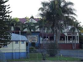
Palmwoods is regarded for its various eating and drinking establishments. The Palmwoods Pub, built in 1902, has recently undergone a multimillion-dollar renovation, and is known for creating job opportunities for backpackers.[9] Ricks Garage, an American themed diner, is one of the most popular eateries in Queensland, and attracts tourists from across eastern Australia.
Amenities
The Sunshine Coast Regional Council operates a mobile library service which visits Main Street.[10]
References
- 1 2 Australian Bureau of Statistics (31 October 2012). "Palmwoods (State Suburb)". 2011 Census QuickStats. Retrieved 26 April 2015.

- ↑ "Palmwoods - town (entry 25926)". Queensland Place Names. Queensland Government. Retrieved 9 April 2017.
- ↑ "Palmwoods - locality (entry 48827)". Queensland Place Names. Queensland Government. Retrieved 9 April 2017.
- 1 2 Environmental Protection Agency (Queensland) (2000). Heritage Trails of the Great South East. State of Queensland. p. 134. ISBN 0-7345-1008-X.
- ↑ Premier Postal History. "Post Office List". Premier Postal Auctions. Retrieved 10 May 2014.
- ↑ History of the Buderim-Palmwoods Tramway from 1911 to 1935. Retrieved 26 April 2015.
- ↑ "Palmwoods to Buderim Tramway Track Foundation and Formwork Remnants (entry 601711)". Queensland Heritage Register. Queensland Heritage Council. Retrieved 14 July 2013.
- ↑ "Another development threat in Palmwoods?". Sunshine Coast Daily. Retrieved 2017-11-26.
- ↑ Slade, Carolyn (2010). Take a Walk Around Palmwoods. Nambour, Qld: Genealogy Sunshine Coast. pp. 61–66. ISBN 9780980353846.
- ↑ "Libraries: Mobile timetable". Sunshine Coast Regional Council. Archived from the original on 30 January 2018. Retrieved 30 January 2018.
External links
| Wikimedia Commons has media related to Palmwoods, Queensland. |