Pakefield to Easton Bavents
| Site of Special Scientific Interest | |
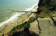 Cliffs at Covehithe | |
| Area of Search | Suffolk |
|---|---|
| Grid reference | TM 519 818[1] |
| Interest |
Biological geological |
| Area | 735.4 hectares[1] |
| Notification | 2005[1] |
| Location map | Magic Map |
Pakefield to Easton Bavents is a 735.4 hectare biological and geological Site of Special Scientific Interest which stretches along the Suffolk coast between Lowestoft and Southwold.[1][2] It includes three Geological Conservation Review sites,[3][4][5] and part of the Benacre National Nature Reserve.[6] An area of 326.7 hectares is the Benacre to Easton Bavents Lagoons Special Area of Conservation,[7][8] and 470.6 hectares is the Benacre to Easton Bavents Special Protection Area under the European Union Directive on the Conservation of Wild Birds.[9][10] The site is also partly in the Suffolk Coast and Heaths Area of Outstanding Natural Beauty.[11]
The site is described by Natural England as nationally important for its exposures of the Lower Pleistocene Norwich Crag Formation, its vegetated shingle features, saline lagoons, flood-plain fens, its nationally scarce vascular plants, and for its scarce breeding birds and wintering bitterns.[12]
References
- 1 2 3 4 "Designated Sites View: Pakefield to Easton Bavents". Sites of Special Scientific Interest. Natural England. Retrieved 7 June 2017.
- ↑ "Map of Pakefield to Easton Bavents". Sites of Special Scientific Interest. Natural England. Retrieved 7 June 2017.
- ↑ "Benacre Ness (Coastal Geomorphology of England)". Geological Conservation Review. Joint Nature Conservation Committee. Retrieved 3 May 2017.
- ↑ "Easton Bavents (Pleistocene Vertebrata)". Geological Conservation Review. Joint Nature Conservation Committee. Retrieved 3 May 2017.
- ↑ "Easton Bavents (Quaternary of East Anglia)". Geological Conservation Review. Joint Nature Conservation Committee. Retrieved 3 May 2017.
- ↑ "Designated Sites View: Benacre". National Nature Reserves. Natural England. Retrieved 5 May 2017.
- ↑ "Benacre to Easton Bavents Lagoons". Special Areas of Conservation. Joint Nature Conservation Committee. Retrieved 4 May 2017.
- ↑ "Designated Sites View: Benacre to Easton Bavents Lagoons". Special Area of Conservation. Natural England. Retrieved 10 May 2017.
- ↑ "Special Protection Areas under the EC Birds Directive. Benacre to Easton Bavents" (PDF). Joint Nature Conservation Committee. Retrieved 4 May 2017.
- ↑ "Designated Sites View: Benacre to Easton Bavents". Special Protection Area. Natural England. Retrieved 10 May 2017.
- ↑ "Suffolk Coast & Heaths Area of Outstanding Natural Beauty Management Plan 2013–2018" (PDF). Suffolk Coast & Heaths AONB. p. 76. Retrieved 6 August 2016.
- ↑ "Pakefield to Easton Bavents citation" (PDF). Sites of Special Scientific Interest. Natural England. Archived from the original on 4 May 2015. Retrieved 7 June 2017.
| Wikimedia Commons has media related to Pakefield to Easton Bavents. |