Buckanay Farm Pit, Alderton
| Site of Special Scientific Interest | |
 | |
| Area of Search | Suffolk |
|---|---|
| Grid reference | TM 356 424[1] |
| Interest | Geological |
| Area | 0.7 hectares[1] |
| Notification | 1988[1] |
| Location map | Magic Map |
Buckanay Farm Pit, Alderton is a 0.7 hectare geological Site of Special Scientific Interest east of Alderton in Suffolk.[1][2] It is a Geological Conservation Review site.[3]
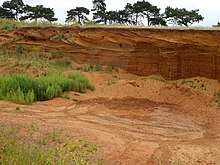
This fossiliferous site exposes rocks of the marine Red Crag Formation, with a megaripple sequence showing the gradual reduction in depth of the sea.[4] The Red Crag spans the end of the Pliocene around 2.6 million years ago and the start of the succeeding Pleistocene.[5]
There is access to the site from Buckanay Lane.
References
- 1 2 3 4 "Designated Sites View: Buckanay Farm Pit, Alderton". Sites of Special Scientific Interest. Natural England. Retrieved 25 June 2017.
- ↑ "Map of Buckanay Farm Pit, Alderton". Sites of Special Scientific Interest. Natural England. Retrieved 25 June 2017.
- ↑ "Buckanay Farm, Alderton (Neogene)". Geological Conservation Review. Joint Nature Conservation Committee. Retrieved 25 June 2017.
- ↑ "Buckanay Farm Pit, Alderton citation" (PDF). Sites of Special Scientific Interest. Natural England. Retrieved 25 June 2017.
- ↑ Brenchley, Patrick J.; Rawson, Peter F., eds. (2006). The Geology of England and Wales (2nd ed.). The Geological Society. pp. 432–434. ISBN 1-86239-200-5.
| Wikimedia Commons has media related to Buckanay Farm Pit, Alderton. |
This article is issued from
Wikipedia.
The text is licensed under Creative Commons - Attribution - Sharealike.
Additional terms may apply for the media files.