Paiçandu
| Paiçandu | |
|---|---|
| Municipality | |
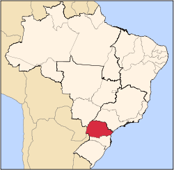
 Paiçandu Location in Brazil | |
| Coordinates: 23°27′20″S 52°2′30″W / 23.45556°S 52.04167°WCoordinates: 23°27′20″S 52°2′30″W / 23.45556°S 52.04167°W | |
| Country |
|
| Region | South Region |
| State | Paraná |
| Area | |
| • Total | 171.4 km2 (66.2 sq mi) |
| Population (2015) | |
| • Total | 39,291 |
| • Density | 230/km2 (590/sq mi) |
| Time zone | BRT/BRST (UTC-3/-2) |
Paiçandu is a city in the state of Paraná in southern Brazil. Paiçandu was founded in 1948, and emancipated on 19 November 1960. Its population was 39,291 (2015) and its area is 171.4 km².[1]
Geography
Climate
Paiçandu's subtropical climate offers hot summers and concentrated wet seasons; Paiçandu has no dry season. The average high temperature is 22 °C. Frost rarely accompanies the winter weather (the average low temperature is 18 °C).
Economy
Participation in the Municipal GIP
- Farming: 8.72%
- Industry: 38.92%
- Services: 52.35%
Number of inhabitants who are actively employed: 14,597
Primary crops
Primary industries
See also
References
This article is issued from
Wikipedia.
The text is licensed under Creative Commons - Attribution - Sharealike.
Additional terms may apply for the media files.