Sertaneja, Paraná
| Sertaneja | |
|---|---|
| Country | Brazil |
| State | Paraná |
| Area | |
| • Total | 444.48 km2 (171.61 sq mi) |
| Elevation | 520 m (1,710 ft) |
| Population (2005) | |
| • Total | 6,383 |
| Time zone | UTC-3 (UTC-3) |
| • Summer (DST) | UTC-2 (UTC-2) |
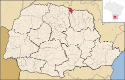
Sertaneja in Paraná state
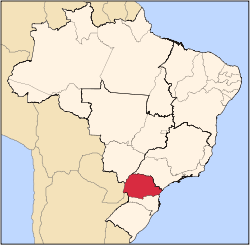
Paraná state in Brazil
Sertaneja is a municipality in the state of Paraná in Brazil. The location coordinates are 23°02′13″S 50°50′16″W. It is 520 meters above sea level.
It was established as a municipality according to Law nº 2/1947, dated 10 October 1947 dividing the earlier Cornélio Procópio municipality into 3 new district municipalities: Sertaneja, Leópolis and Congonhas.
The municipal area of Sertaneja is 444,48 km² and its population 6,383 (2005).
References
Coordinates: 23°03′S 50°50′W / 23.050°S 50.833°W
This article is issued from
Wikipedia.
The text is licensed under Creative Commons - Attribution - Sharealike.
Additional terms may apply for the media files.