Santo Antônio do Caiuá
| Santo Antônio do Caiuá | |
|---|---|
| Municipality | |
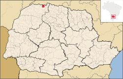 Location in Paraná state | |
 Santo Antônio do Caiuá Location in Brazil | |
| Coordinates: 22°44′6″S 52°20′31″W / 22.73500°S 52.34194°WCoordinates: 22°44′6″S 52°20′31″W / 22.73500°S 52.34194°W | |
| Country |
|
| Region | South Region |
| State | Paraná |
| Mesoregion | Noroeste Paranaense |
| Microregion | Paranavaí |
| Area | |
| • Total | 219.07 km2 (84.58 sq mi) |
| Population (2015) | |
| • Total | 2,757 |
| • Density | 13/km2 (33/sq mi) |
| Time zone | BRT/BRST (UTC-3/-2) |
| Website | www.stoantoniocaiua.pr.gov.br |
Santo Antônio do Caiuá is a municipality in the northwestern part of the state of Paraná, Brazil. The population is 2,757 (2015 est.) in an area of 219.07 km².[1] The municipality was founded in 1961.
References
External links
- http://www.citybrazil.com.br/sp/stoantoniocaiua/ (in Portuguese)
This article is issued from
Wikipedia.
The text is licensed under Creative Commons - Attribution - Sharealike.
Additional terms may apply for the media files.