Příbram na Moravě
| Příbram na Moravě | |||
|---|---|---|---|
| Municipality | |||
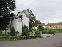 Chapel of Saint Florian | |||
| |||
 Příbram na Moravě | |||
| Coordinates: 49°11′43″N 16°18′23″E / 49.19528°N 16.30639°ECoordinates: 49°11′43″N 16°18′23″E / 49.19528°N 16.30639°E | |||
| Country |
| ||
| Region | South Moravian | ||
| District | Brno-Country | ||
| Area | |||
| • Total | 11.92 km2 (4.60 sq mi) | ||
| Elevation | 440 m (1,440 ft) | ||
| Population | |||
| • Total | 548 | ||
| • Density | 46/km2 (120/sq mi) | ||
| Postal code | 664 84 | ||
| Website | http://www.pribramnamorave.cz/ | ||


Příbram na Moravě is a village and municipality (obec) in Brno-Country District in the South Moravian Region of the Czech Republic.
The municipality covers an area of 11.92 square kilometres (4.60 sq mi), and has a population of 548.
Příbram na Moravě lies approximately 23 kilometres (14 mi) west of Brno and 169 km (105 mi) south-east of Prague.
References
| Wikimedia Commons has media related to Příbram na Moravě. |
This article is issued from
Wikipedia.
The text is licensed under Creative Commons - Attribution - Sharealike.
Additional terms may apply for the media files.