Měnín
| Měnín | |||
|---|---|---|---|
| Municipality | |||
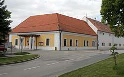 Municipal office | |||
| |||
 Měnín | |||
| Coordinates: 49°4′33″N 16°41′39″E / 49.07583°N 16.69417°ECoordinates: 49°4′33″N 16°41′39″E / 49.07583°N 16.69417°E | |||
| Country |
| ||
| Region | South Moravian | ||
| District | Brno-Country | ||
| Area | |||
| • Total | 21.16 km2 (8.17 sq mi) | ||
| Elevation | 188 m (617 ft) | ||
| Population (2006) | |||
| • Total | 1,735 | ||
| • Density | 82/km2 (210/sq mi) | ||
| Postal code | 664 57 | ||
| Website | http://www.menin.cz | ||

Měnín (German: Mönitz) is a village and municipality (obec) in Brno-Country District in the South Moravian Region of the Czech Republic.
The municipality covers an area of 21.16 square kilometres (8.17 sq mi), and has a population of 1,632 (as at 3 July 2006).
Měnín lies approximately 15 kilometres (9 mi) south of Brno and 199 km (124 mi) south-east of Prague.
References
| Wikimedia Commons has media related to Měnín. |
This article is issued from
Wikipedia.
The text is licensed under Creative Commons - Attribution - Sharealike.
Additional terms may apply for the media files.