Troskotovice
| Troskotovice | |
|---|---|
| Městys | |
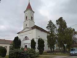 Church of Saint Wenceslaus | |
 Troskotovice | |
| Coordinates: 48°55′10″N 16°26′26″E / 48.91944°N 16.44056°ECoordinates: 48°55′10″N 16°26′26″E / 48.91944°N 16.44056°E | |
| Country |
|
| Region | South Moravian |
| District | Brno-Country |
| Area | |
| • Total | 18.12 km2 (7.00 sq mi) |
| Elevation | 193 m (633 ft) |
| Population (2006) | |
| • Total | 626 |
| • Density | 35/km2 (89/sq mi) |
| Postal code | 671 78 |
| Website | http://www.troskotovice.cz |
Troskotovice is a market town (městys) in Brno-Country District in the South Moravian Region of the Czech Republic.
The town covers an area of 18.12 square kilometres (7.00 sq mi), and has a population of 626 (as at 28 August 2006).
Troskotovice lies approximately 34 kilometres (21 mi) south of Brno and 196 km (122 mi) south-east of Prague.
References
| Wikimedia Commons has media related to Troskotovice. |
This article is issued from
Wikipedia.
The text is licensed under Creative Commons - Attribution - Sharealike.
Additional terms may apply for the media files.