Šlapanice
- See other locations named Šlapanice.
| Šlapanice | |||
| City | |||
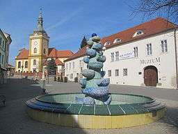 City Centre Square | |||
|
|||
| Official name: Šlapanice u Brna | |||
| Nickname: Šlapky | |||
| Country | Czech Republic | ||
|---|---|---|---|
| State | South Moravia | ||
| Region | South Moravian | ||
| District | Brno-Country | ||
| Commune | Šlapanice | ||
| Elevation | 230 m (755 ft) | ||
| Coordinates | 49°10′N 16°43′E / 49.167°N 16.717°ECoordinates: 49°10′N 16°43′E / 49.167°N 16.717°E | ||
| Area | 14.64 km2 (5.65 sq mi) | ||
| Population | 7,000 (1.1.2014) | ||
| Density | 478/km2 (1,238/sq mi) | ||
| First mentioned | 1235 | ||
| Mayor | Jaroslav Klaška | ||
| Timezone | CET (UTC+1) | ||
| - summer (DST) | CEST (UTC+2) | ||
| Postal code | CZ-66451 | ||
  Location in the Czech Republic | |||
| Wikimedia Commons: Šlapanice | |||
| Statistics: statnisprava.cz | |||
| Website: www.slapanice.cz | |||


Šlapanice (Czech pronunciation: [ˈʃlapaɲɪtsɛ]) is a town in the South Moravian Region of the Czech Republic, neighbour to Brno. It had around 7,000 inhabitants in the year 2013.
Village Bedřichovice is administrative part of Šlapanice.
External links
| Wikimedia Commons has media related to Šlapanice. |
This article is issued from
Wikipedia.
The text is licensed under Creative Commons - Attribution - Sharealike.
Additional terms may apply for the media files.