Ostrhauderfehn
| Ostrhauderfehn | ||
|---|---|---|
| ||
 Ostrhauderfehn Location of Ostrhauderfehn within Leer district 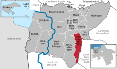  | ||
| Coordinates: 53°07′N 07°37′E / 53.117°N 7.617°ECoordinates: 53°07′N 07°37′E / 53.117°N 7.617°E | ||
| Country | Germany | |
| State | Lower Saxony | |
| District | Leer | |
| Government | ||
| • Mayor | Günter Harders (Ind.) | |
| Area | ||
| • Total | 51.00 km2 (19.69 sq mi) | |
| Elevation | 3 m (10 ft) | |
| Population (2017-12-31)[1] | ||
| • Total | 11,198 | |
| • Density | 220/km2 (570/sq mi) | |
| Time zone | CET/CEST (UTC+1/+2) | |
| Postal codes | 26842 | |
| Dialling codes | 0 49 52 | |
| Vehicle registration | LER | |
| Website | www.ostrhauderfehn.de | |

Ostrhauderfehn (Low German: Osterfehn) is a municipality in the Leer district of Lower Saxony, Germany.
It split from Rhauderfehn sometime between 1820 and 1830. Ostrhauderfehn was for many years one of the largest municipalities in the district of Leer.
Towns and municipalities in Leer (district) | ||
|---|---|---|
References
This article is issued from
Wikipedia.
The text is licensed under Creative Commons - Attribution - Sharealike.
Additional terms may apply for the media files.