Moormerland
| Moormerland | ||
|---|---|---|
| ||
 Moormerland Location of Moormerland within Leer district 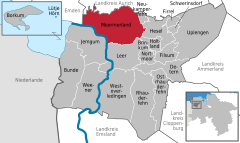  | ||
| Coordinates: 53°19′11″N 7°25′22″E / 53.31972°N 7.42278°ECoordinates: 53°19′11″N 7°25′22″E / 53.31972°N 7.42278°E | ||
| Country | Germany | |
| State | Lower Saxony | |
| District | Leer | |
| Government | ||
| • Mayor | Anton Lücht (SPD) | |
| Area | ||
| • Total | 122 km2 (47 sq mi) | |
| Elevation | 1 m (3 ft) | |
| Population (2017-12-31)[1] | ||
| • Total | 23,474 | |
| • Density | 190/km2 (500/sq mi) | |
| Time zone | CET/CEST (UTC+1/+2) | |
| Postal codes | 26802 | |
| Dialling codes | 04954, 04945, 04924 | |
| Vehicle registration | LER | |
| Website | moormerland.conne.net | |

Moormerland is a municipality in the Leer District, in Lower Saxony, northwestern Germany.
Towns and municipalities in Leer (district) | ||
|---|---|---|
References
This article is issued from
Wikipedia.
The text is licensed under Creative Commons - Attribution - Sharealike.
Additional terms may apply for the media files.