Rhauderfehn
| Rhauderfehn | ||
|---|---|---|
| ||
 Rhauderfehn Location of Rhauderfehn within Leer district 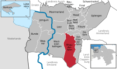  | ||
| Coordinates: 53°10′N 07°33′E / 53.167°N 7.550°ECoordinates: 53°10′N 07°33′E / 53.167°N 7.550°E | ||
| Country | Germany | |
| State | Lower Saxony | |
| District | Leer | |
| Government | ||
| • Mayor | Geert Müller | |
| Area | ||
| • Total | 102.92 km2 (39.74 sq mi) | |
| Elevation | 4 m (13 ft) | |
| Population (2017-12-31)[1] | ||
| • Total | 17,850 | |
| • Density | 170/km2 (450/sq mi) | |
| Time zone | CET/CEST (UTC+1/+2) | |
| Postal codes | 26817 | |
| Dialling codes | 0 49 52 | |
| Vehicle registration | LER | |
| Website | www.rhauderfehn.de | |

Rhauderfehn is a municipality in the Leer district, in Lower Saxony, Germany.
Towns and municipalities in Leer (district) | ||
|---|---|---|
References
This article is issued from
Wikipedia.
The text is licensed under Creative Commons - Attribution - Sharealike.
Additional terms may apply for the media files.