Jemgum
| Jemgum | |||
|---|---|---|---|
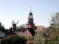 The church and windmill of Ditzum in Jemgum municipality | |||
| |||
 Jemgum Location of Jemgum within Leer district 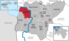  | |||
| Coordinates: 53°15′57″N 07°23′06″E / 53.26583°N 7.38500°ECoordinates: 53°15′57″N 07°23′06″E / 53.26583°N 7.38500°E | |||
| Country | Germany | ||
| State | Lower Saxony | ||
| District | Leer | ||
| Government | |||
| • Mayor | Hans-Peter Heikens (Ind.) | ||
| Area | |||
| • Total | 78.48 km2 (30.30 sq mi) | ||
| Elevation | 0 m (0 ft) | ||
| Population (2017-12-31)[1] | |||
| • Total | 3,583 | ||
| • Density | 46/km2 (120/sq mi) | ||
| Time zone | CET/CEST (UTC+1/+2) | ||
| Postal codes | 26844 | ||
| Dialling codes | 0 49 58 | ||
| Vehicle registration | LER | ||
| Website | www.jemgum.de | ||

Jemgum is a municipality in the Leer district, in the northwest of Lower Saxony, Germany. The area is known as Rheiderland (German) or Reiderland (Dutch). Rheiderland is located in East Friesland. The East Friesland area of Germany (also known in English as East Frisia) is home to German writers Georg Klein (Bunde) and Uwe Kreisel (Jemgum).
History
Jemgum was the site of the Battle of Jemmingen on 21 July 1568, an early event of the Eighty Years' War, in which a Spanish army defeated a Dutch Rebel army under Louis of Nassau.
References
Towns and municipalities in Leer (district) | ||
|---|---|---|
| Authority control |
|---|
This article is issued from
Wikipedia.
The text is licensed under Creative Commons - Attribution - Sharealike.
Additional terms may apply for the media files.