Okanagan Highland
| Okanagan Highland | |
|---|---|
| Okanogan Highlands | |
|
Montane Spruce Zone overlooking Browne Lake in the Okanagan Highland | |
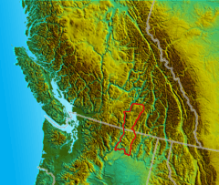 Location map of the Okanagan Highland | |
| Coordinates | 49°35′00″N 119°00′00″W / 49.58333°N 119.00000°WCoordinates: 49°35′00″N 119°00′00″W / 49.58333°N 119.00000°W[1] |
| Age | Mesozoic |
The Okanagan Highland is an elevated hilly plateau area in British Columbia, Canada, and the U.S. state of Washington (where it is spelled Okanogan Highlands). Rounded mountains with elevations up to 8,000 feet above sea level and deep, narrow valleys are characteristic of the region.
BC Geographical Names, a service of the British Columbia Integrated Land Management Bureau, defines the Okanagan Highland as an area extending southward from the Shuswap River and the Coldstream Valley, east of Vernon, British Columbia, for 85 miles to the 49th parallel and into the State of Washington, lying between the Monashee Mountains on the east, and the Thompson Plateau and the Okanagan Valley on the west. The eastern boundary of the Okanagan Highland is clearly defined by the valley of the Kettle River. The western boundary is drawn arbitrarily and is somewhat difficult to define, because there are no natural features to follow between Penticton in the Okanagan Valley and Lumby in the Coldstream Valley.[2]
The Washington State Department of Natural Resources describes the "Okanogan Highlands" as a larger area, extending from east of the Cascade Mountains and north of the Columbia Basin into northern Idaho and the Shuswap Highland in British Columbia. This region includes FDR Reservoir (the impounded Columbia River above Grand Coulee Dam), the Kettle River Range, and the southern portion of the Monashee Mountains.[3]
The highest summit in the Highland is Big White Mountain, at its northeastern extremity, which is also the highest summit of the Beaverdell Range, a mountain range which extends south from Big White between the Kettle and West Kettle Rivers. Other notable summits are Okanagan Mountain, Little White Mountain, Mount Baldy, Mount Hull, and Mount Bonaparte which is the highest summit in the US portion of the Highland.
The Okanagan Highland is the source of several rivers in addition to the Kettle and West Kettle, including the Sanpoil River.
See also
References
- ↑ "Okanagan Highland". BC Geographical Names.
- ↑ Stuart S. Holland (1976). Landforms of British Columbia: A Physiographic Outline, Bulletin 48 (PDF) (Report). Province of British Columbia. pp. 74–75. Retrieved 14 November 2015.
- ↑ Washington State Department of Natural Resources, Geology of Washington - Okanogan Highlands Archived March 20, 2012, at the Wayback Machine., downloaded 15 March 2012