Orange Farm
| Orange Farm Farmton | |
|---|---|
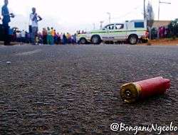 Orange Farm Youth Protest | |
 Orange Farm  Orange Farm Orange Farm (South Africa)  Orange Farm Orange Farm (Africa) | |
| Coordinates: 26°27′54″S 27°51′25″E / 26.465°S 27.857°ECoordinates: 26°27′54″S 27°51′25″E / 26.465°S 27.857°E | |
| Country | South Africa |
| Province | Gauteng |
| District | 11 |
| Municipality | City of Johannesburg |
| Established | 1988 |
| Government | |
| • Councillor | Motha (ANC) |
| Area[1] | |
| • Total | 12.16 km2 (4.70 sq mi) |
| Population (2011)[1] | |
| • Total | 76,767 |
| • Density | 6,300/km2 (16,000/sq mi) |
| Racial makeup (2011)[1] | |
| • Black African | 99.3% |
| • Coloured | 0.3% |
| • Indian/Asian | 0.1% |
| • White | 0.1% |
| • Other | 0.2% |
| First languages (2011)[1] | |
| • Zulu | 44.5% |
| • Sotho | 29.1% |
| • Xhosa | 9.5% |
| • Tsonga | 4.1% |
| • Other | 12.8% |
| Time zone | UTC+2 (SAST) |
| Postal code (street) | 1805 |
| PO box | 1805 |
| Area code | 1841 |
Orange Farm ("Farma") is a township located approximately 45 km from Johannesburg, Gauteng Province, South Africa. Its name, a misnomer given that oranges are grown in orchards instead of farms, has Dutch origins. It is one of the youngest townships in South Africa, with the original inhabitants, laid-off farm workers, taking up residency in 1988. Support for the population came slowly mostly from people who were tenants at the great township of Soweto.[2]
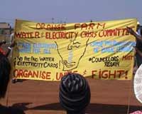
The Orange Farm Water Crisis Committee, an offshoot of the South African Anti-Privatization Forum (AFP), has been very vocal and active against the privatization of water.
Approximately 85% of the people work in Johannesburg. Most of the people use train to get to work. 35% of the residents are unemployed and the stats rise every year as the matriculates join them.
Infrastructure
Orange Farm is a rapidly growing township with great infrastructural developments each year. The township has a large main clinic (Stretford Clinic[3]) and several minor clinics. The township's main roads are tarred and several minor streets may be tarred but in questionable condition. Orange farm has a small official library, permanent housing for many residents (mainly government housing) . Electricity is readily available to most places with only a few areas without electricity (including the Squatter camp in Drieziek 5). The town has a large multi-purpose community center.
However, these improvements come with financial costs, which most of the citizens living in Orange Farm cannot afford. The ongoing privatization of Orange Farm has also drawn much criticism from social justice and human rights groups as they have pointed out that local small businesses keep dying. This can also be linked to the rising number of foreign owned shops in the area. A lot has been done to improve Orange Farm; it now has more than two parks and a two floor mall (Eyethu Orange Farm Mall). However, nearly all areas still need improvement.
Parks
Mountain Road Park (opened 12 October 2014) is situated in Orange Farm Ext 2, 1 km away from Eyethu Orange Farm Mall. This park sits where there used to be a soccer/football pitch of Ext 2 (Liver Pool Grouds).
Education
High Schools
- Vulanindlela Secondary School
- Leshata Secondary School
- Mphethi Mahlatsi Secondary School
- Aha-thuto Secondary School
- Jabulile Secondary School
- Thamsanqa Secondary School
- Thetha Secondary School
- Vutomi Secondary School
- Isikhumbuzo Secondary School
- Siyaphambili Secondary School
- Sinqobile Secondary School
- Masibambane College
- Raphela Secondary School
- Qoqa Secondary School
- Orange Farm Secondary School
Gauteng Digital Schools
In 2015, the first stage in the Gauteng Digital Schools project was launched. The Gauteng Department of Education aims to transform all schools in the province to paperless schools. The project is headed by the MEC for Education, Panyaza Lesufi. The project began with replacing traditional chalkboards with large, touch-operated electronic screens and every learner receiving a Huawei 10" tablet computer. For 2015, the changes were only made to grade 12 classes and students. Most government schools in the province (Orange Farm included) were equipped with "smart" grade 12 classes. If the project succeeds all schools and grades in Orange Farm will become completely paperless and digitalised.
Notable people of Orange Farm
- Sthembinkosi Junior Bikwa,[4] actor
- Ntando Duma,[5] actor
Climate
Köppen-Geiger climate classification system classifies its climate as subtropical highland (Cwb).[6]
| Climate data for Orange Farm | |||||||||||||
|---|---|---|---|---|---|---|---|---|---|---|---|---|---|
| Month | Jan | Feb | Mar | Apr | May | Jun | Jul | Aug | Sep | Oct | Nov | Dec | Year |
| Average high °C (°F) | 26.4 (79.5) |
25.8 (78.4) |
24.7 (76.5) |
22.1 (71.8) |
19.6 (67.3) |
16.9 (62.4) |
17.3 (63.1) |
20.3 (68.5) |
23.4 (74.1) |
25 (77) |
25.3 (77.5) |
26.1 (79) |
22.7 (72.9) |
| Daily mean °C (°F) | 20.4 (68.7) |
19.8 (67.6) |
18.5 (65.3) |
15.5 (59.9) |
12.1 (53.8) |
9 (48) |
9.2 (48.6) |
12.1 (53.8) |
15.7 (60.3) |
18 (64) |
19 (66) |
19.9 (67.8) |
15.8 (60.3) |
| Average low °C (°F) | 14.4 (57.9) |
13.9 (57) |
12.3 (54.1) |
8.9 (48) |
4.6 (40.3) |
1.2 (34.2) |
1.2 (34.2) |
4 (39) |
8 (46) |
11 (52) |
12.7 (54.9) |
13.7 (56.7) |
8.8 (47.9) |
| Average precipitation mm (inches) | 136 (5.35) |
101 (3.98) |
84 (3.31) |
63 (2.48) |
20 (0.79) |
8 (0.31) |
7 (0.28) |
7 (0.28) |
24 (0.94) |
73 (2.87) |
112 (4.41) |
115 (4.53) |
750 (29.53) |
| Source: Climate-Data.org, altitude: 1667m[6] | |||||||||||||
References
- 1 2 3 4 "Main Place Orange Farm". Census 2011.
- ↑ "Orange Farm, South Africa". City of Johannesburg. Retrieved 14 February 2014.
- ↑ http://www.yellowpages.co.za/business/SA_8417970_BUS
- ↑ https://www.tvsa.co.za/actors/viewactor.aspx?actorid=12056
- ↑ http://www.timeslive.co.za/entertainment/2016/11/30/Ntando-Dumas-childhood-pain-My-father-was-really-abusive-and-set-our-shack-alight
- 1 2 "Climate: Soweto - Climate graph, Temperature graph, Climate table". Climate-Data.org. Retrieved 25 September 2013.