Oakwood Heights station
Oakwood Heights | ||||||||||||||||||||||||||||||||||||||||||||||||||||||||||||||||||||||||||||
|---|---|---|---|---|---|---|---|---|---|---|---|---|---|---|---|---|---|---|---|---|---|---|---|---|---|---|---|---|---|---|---|---|---|---|---|---|---|---|---|---|---|---|---|---|---|---|---|---|---|---|---|---|---|---|---|---|---|---|---|---|---|---|---|---|---|---|---|---|---|---|---|---|---|---|---|---|
|
| ||||||||||||||||||||||||||||||||||||||||||||||||||||||||||||||||||||||||||||
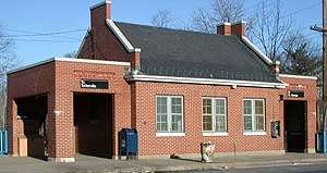 Exterior of Oakwood Heights SIR Station | ||||||||||||||||||||||||||||||||||||||||||||||||||||||||||||||||||||||||||||
| Station statistics | ||||||||||||||||||||||||||||||||||||||||||||||||||||||||||||||||||||||||||||
| Address |
Guyon Avenue & South Railroad Avenue Staten Island, NY 10306 | |||||||||||||||||||||||||||||||||||||||||||||||||||||||||||||||||||||||||||
| Borough | Staten Island | |||||||||||||||||||||||||||||||||||||||||||||||||||||||||||||||||||||||||||
| Locale | Oakwood | |||||||||||||||||||||||||||||||||||||||||||||||||||||||||||||||||||||||||||
| Coordinates | 40°33′53″N 74°07′37″W / 40.5647°N 74.1269°WCoordinates: 40°33′53″N 74°07′37″W / 40.5647°N 74.1269°W | |||||||||||||||||||||||||||||||||||||||||||||||||||||||||||||||||||||||||||
| Services |
Local | |||||||||||||||||||||||||||||||||||||||||||||||||||||||||||||||||||||||||||
| Transit connections |
| |||||||||||||||||||||||||||||||||||||||||||||||||||||||||||||||||||||||||||
| Structure | Open-cut | |||||||||||||||||||||||||||||||||||||||||||||||||||||||||||||||||||||||||||
| Platforms | 2 side platforms | |||||||||||||||||||||||||||||||||||||||||||||||||||||||||||||||||||||||||||
| Tracks | 2 | |||||||||||||||||||||||||||||||||||||||||||||||||||||||||||||||||||||||||||
| Other information | ||||||||||||||||||||||||||||||||||||||||||||||||||||||||||||||||||||||||||||
| Opened | April 23, 1860[1] | |||||||||||||||||||||||||||||||||||||||||||||||||||||||||||||||||||||||||||
| Station code | 511[2] | |||||||||||||||||||||||||||||||||||||||||||||||||||||||||||||||||||||||||||
| Former/other names |
Richmond Court House Oakwood | |||||||||||||||||||||||||||||||||||||||||||||||||||||||||||||||||||||||||||
| Station succession | ||||||||||||||||||||||||||||||||||||||||||||||||||||||||||||||||||||||||||||
| Next north | New Dorp | |||||||||||||||||||||||||||||||||||||||||||||||||||||||||||||||||||||||||||
| Next south | Bay Terrace | |||||||||||||||||||||||||||||||||||||||||||||||||||||||||||||||||||||||||||
| ||||||||||||||||||||||||||||||||||||||||||||||||||||||||||||||||||||||||||||
| ||||||||||||||||||||||||||||||||||||||||||||||||||||||||||||||||||||||||||||
| ||||||||||||||||||||||||||||||||||||||||||||||||||||||||||||||||||||||||||||


Oakwood Heights is a Staten Island Railway station in the neighborhood of Oakwood, Staten Island, New York.
History
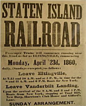
The station opened as Richmond on April 23, 1860, with the opening of the Staten Island Railway from Vanderbilt's Landing to Eltingville.[1][3] The station was named Richmond[4] as the station was on the border between Richmond and Oakwood. Afterwards, sometime around 1885 the station was renamed Court House.[5] The station was a flag stop.[6] The station was later renamed Oakwood,[7] and then finally Oakwood Heights after the other neighborhood on the border of the station. A 1909 timetable calls the station Oakwood Heights, but puts Court House in parentheses.[5]
Station layout
| G | Street level | Exit/Entrance |
| P Platforms |
Side platform, doors will open on the right | |
| Southbound | ←Tottenville toward Tottenville (Bay Terrace) | |
| Northbound | → St. George toward St. George (New Dorp) → | |
| Side platform, doors will open on the right | ||
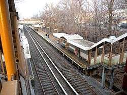
The station is located on an open cut at Guyon Avenue and Railroad Avenue. It has two side platforms and beige painted walls. This station is used frequently by students of the nearby Monsignor Farrell High School.
Exits
The north end has an overpass with two exits, one to Oak Avenue for the northbound platform, and the other to Cedarview Avenue for the southbound platform side. Another exit at the south end leads to Guyon Avenue.[8]
Bus connection
References
- 1 2 Irvin Leigh and Paul Matus (December 23, 2001). "SIRT The Essential History". p. 4. Retrieved March 3, 2009.
- ↑ "Station Developers' Information". Metropolitan Transportation Authority. Retrieved June 13, 2017.
- ↑ Poster for opening of Staten Island Railway
- ↑ "File:Staten Island Railway 1867.jpg". wikipedia.org. June 1868 first edition of the Official Guide of the Railways.
- 1 2 "File:A Map of the Staten Island Rapid Transit Company from 1885.png". wikimedia.org.
- ↑ "1887 SIRT Timetable". Flickr. Retrieved March 24, 2017.
- ↑ "SIRT 1915 Ticket". Flickr — Photo Sharing!.
- ↑ "Map of NYC Subway Entrances". NYC Open Data. City of New York. Retrieved July 10, 2018.
External links
![]()