Interstate 77 in North Carolina
| ||||
|---|---|---|---|---|
|
I-77 highlighted in red | ||||
| Route information | ||||
| Maintained by NCDOT | ||||
| Length | 105.7 mi[1][2] (170.1 km) | |||
| Existed | 1965 – present | |||
| Major junctions | ||||
| South end |
| |||
|
| ||||
| North end |
| |||
| Location | ||||
| Counties | Mecklenburg, Iredell, Yadkin, Surry | |||
| Highway system | ||||
| ||||

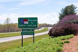
Interstate 77 (I-77) is a part of the Interstate Highway System that runs from Columbia, South Carolina to Cleveland, Ohio. In North Carolina, I-77 enters the state in Charlotte, from South Carolina. Crossing the western piedmont, it connects with the control city of Statesville before continuing north into Virginia. The landscapes traversed by I-77 is a contrast of urban and rural foothills, with views of the Blue Ridge Mountains seen from a distance on its most northern section. The interstate has a total of 105.7 miles (170.1 km) and has one auxiliary route.
The freeway bears several names in addition to the I-77 designation. Throughout the state the freeway is known as the Blue Star Memorial Highway, a name shared with multiple interstates across the state. Starting at the South Carolina state, it is known as the General Paul R. Younts Expressway, switching at Woodlawn Road to the Bill Lee Freeway, ending at the Mecklenburg-Iredell county line. In Surry County, it is known as the Charles M. Shelton Highway.[3][4][5]
Not originally part of the Federal Aid Highway Act of 1956, it was added the following year as a route between Charlotte and Port Huron, Michigan. In 1958, the routing was realigned towards Cleveland, Ohio instead. I-77 received two extension approvals; the first in 1964, continuing south from Interstate 85 (I-85) to U.S. Route 74 (US 74), and the second in 1969 to the South Carolina state line towards Columbia. The interstate was completed in 1977.
Route description
Interstate 77 begins at the South Carolina state line, near Fort Mill, in concurrency with US 21. I-77 goes through the city of Charlotte as a major north–south corridor, connecting the Center City with the suburbs of Pineville, Huntersville, Cornelius, and Davidson. Shortly after entering North Carolina, it expands to six lanes. Between I-485 (exit 2) and I-277 (exit 9), the highway experiences massive traffic congestion during weekday rush hours (7:00-9:30 a.m./4:00-6:30 p.m.) due to commuter traffic. Just north of Center City, I-77 makes a unique interchange configuration with Interstate 85, with north and southbound lanes crisscrossing briefly. Between I-85 (exit 13) and I-485 (exit 19), I-77 features the state's only HOV lanes. After I-485, I-77 reduces to five lanes (three lanes northbound), then to four lanes after Gilead Road (exit 23).
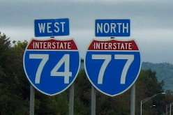
At Lake Norman, I-77 crosses into Iredell County and becomes a more suburban interstate, passing by Mooresville and then Statesville, where it intersects with Interstate 40. It turns more rural outside of Statesville and becomes entirely rural after exiting Iredell County. For the rest of I-77's stretch through North Carolina, the only possible rest stop is the town of Elkin; the speed limit through this area is 70 mph (110 km/h). The final 5 miles (8.0 km) of I-77 is concurrent with Interstate 74 to the Virginia state line (where I-74 ends), all within view of the Blue Ridge Mountains.[1]
Express lanes
The I-77 Express lanes were financed, developed, constructed and are operated and maintained by I-77 Mobility Partners, in a public-private partnership with the North Carolina Department of Transportation. The express lanes replaced the first and only high occupancy vehicle (HOV) lanes in North Carolina, which existed from 2004-2015.[6][7][8]
To be opened in late 2018, the 26-mile (42 km) high-occupancy toll (HOT) lanes are contained entirely withing the median of I-77, with various connecting points to-and-from the general purpose lanes and direct access to northbound I-85 and southbound I-277/NC 16 (Brookshire Freeway). The express lanes begin with four lanes (two-lanes for each direction) at Brookshire Freeway (exit 11), in Charlotte; reduce to two-lanes (one-lane for each direction) at Catawba Avenue, in Cornelius; and end at NC 150 (exit 36), in Mooresville. The tentative maximum speed limit is 65 mph (100 km/h) with a minimum speed limit at 45 mph (70 km/h).[9]
Only vehicles with two axles or motorcycles are allowed on the express lanes. Emergency vehicles when responding to emergencies and mass transit vehicles are exempt and are not tolled.[9]
Tolls
The express lanes uses all-electronic tolling, with tolls payable with valid transponder (NC Quick Pass, E-ZPass, Peach Pass or SunPass) or Bill by mail, which uses automatic license plate recognition and charge a higher rate with additional fees. Toll rates are based on a congestion pricing, which means the tolls will fluctuate based on a number of factors, including congestion levels, time of day, and maintaining an average travel speed of 45 mph (70 km/h) or faster; toll rate changes may occur as frequently as every five minutes, though drivers will only pay the rate displayed when entering the express lanes.[9]
As of September, 2018, the express lanes will use a fixed rate based on segment and time-of-day for the first 180 days of operation, with a cost between $0.30~$11.00 one-way with valid transponder.[10]
HOV3+
Vehicles with three passengers or more may use the express lanes for free, provided they have a E-ZPass Flex Transponder or notify via the HOV mobile app/website, with at least 15 minutes before traveling. Violators are subject to a fine of up to $100 plus court costs; as well as two points against their driver's license for each HOV infraction. Motorcycle drivers with a valid transponder may use the express lanes for free.[6][9][11]
History
Interstate 77 was not part of the original plans for 714 miles (1,149 km) of the nation's Interstate Highway System in North Carolina when they were conveyed in 1956 by the then-North Carolina State Highway Commission. I-77 was added in 1957, increasing the state's mileage to 776 miles (1,249 km).[12]
On 4 August 1959, the commission selected the routing of I-77 to run between Interstate 85 in Charlotte and a point on the Virginia border in Elkin. That would change in late 1960, when the commission voted to route the highway just west of Mount Airy, saying the route would serve the most people.
With construction beginning in the 1960s, I-77 would gain additional mileage in October 1964 when a two-mile (3 km) extension was granted by the U.S. Bureau of Public Roads. Instead of ending at I-85, I-77 now ended at Independence Boulevard (U.S. 74) in downtown Charlotte. Another extension was granted in the late 1960s that extended I-77 from Independence Boulevard to the South Carolina border. The latest extension also included a relocation of U.S. 21 from the city's surface streets to the new interstate.
I-77 opened to traffic in the following segments:
- 1965: Yadkin and Surry counties.
- 1966: A 23-mile (37 km) stretch in Iredell County.
- 1967: Stretches in Mecklenburg, Yadkin and Iredell counties.
- 1968: A stretch of highway in the Davidson and Cornelius areas in Mecklenburg and Iredell counties.
By 1972, I-77 was open from Exit 28 (NC 73) to Exit 73 north of Elkin. The last two sections of the highway to open to traffic was the stretch from Cornelius to Charlotte in 1975 and from Exit 73 to the Virginia state line in 1977.
In April 2001, I-74 was overlapped with I-77 from the Virginia state line to exit 101.[13]
On December 17, 2004, I-77 was widened to six-lanes with HOV lanes, between I-85 to the proposed location of I-485 (later opened 8 December 2008).[6]
On June 28, 2013, a new interchange was added in Mooresville, exit 35: Brawley School Road. The interchange was built with additional shoulder space and lights that will not need to be moved when I-77 is eventually widened in area.[14]
In 2015, NCDOT signed a contract with I-77 Mobility Partners to begin construction and eventual management of the toll lanes starting in 2018.[15] However, new criticism erupted before the financial agreement was made when local politicians discovered the contract was amended in 2014 giving I-77 Mobility Partners a 50-year non-compete clause. The clause eliminated any future widening of additional free-lanes between Charlotte Center City and Mooresville; or if any additional free-lanes were added, then NCDOT would have to pay the developer compensation.[16][17]
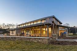
On February 1, 2018, NCDOT opened a new rest area located in the median of I-77, at mile marker 58. Construction of the 5,000 square feet (460 m2), $15 million facility started in the spring of 2015. With the opening of the facility, four older rest areas in Iredell and Yadkin counties, built in 1972-73, were closed.[18]
Future

Interstate 77 is planned to have its existing southbound travel lanes widened (not add more lanes), between I-277/NC 16 (Brookshire Freeway) to I-85 in Charlotte. Estimated to cost $16.5 Million, the purpose of the project is to widen the lanes back to proper Interstate standards as agreed with FHWA, when NCDOT were given design exceptions when adding the HOV lanes in 2004. Construction is tentatively scheduled to begin in late 2016.[19]
As of June 2016, HOT lanes are being constructing along Interstate 77. The project is broken into two parts: the first is constructing new travel lanes from I-485 interchange (exit 19) to West Catawba Avenue (exit 28), at an estimated cost of $57 million. The second would be to convert the existing HOV lanes from Brookshire Boulevard (exit 11) to I-485 (exit 19). After completion, drivers and motorcyclists can still use the lane for free if qualified under HOV rules, non-compliant drivers will be charged a toll.[20][21][22][23]
The I-40/I-77 interchange (exit 51) is undergoing a major upgrade in three phases: reconstruction of nearby intersections on both interstates, reconstruction and widening of I-40/I-77 interchange, and construction of new ramps at the interchange. The estimated cost for the entire project is $251 million and construction began in March 2012. It will replace the current interchange, which was built in the late 1960s.[24][25][26]
Auxiliary routes in North Carolina
| Interstate | City | Type | Notes | |
|---|---|---|---|---|
| Interstate 277 | Charlotte | Beltway | A complete loop around Charlotte center city |
Exit list
| County | Location | mi[1] | km | Exit | Destinations | Notes |
|---|---|---|---|---|---|---|
| Mecklenburg | Charlotte | 0.0 | 0.0 | Continuation from South Carolina | ||
| 0.9 | 1.4 | 1A | Westinghouse Boulevard | Formerly exit 1 before August 2010 | ||
| 1.8 | 2.9 | 1B | Formerly exit 2 (southbound) before August 2010 | |||
| 2.8 | 4.5 | 3 | Arrowood Road | Formerly exit 2 (northbound) before August 2010 | ||
| 3.7 | 6.0 | 4 | Nations Ford Road | |||
| 4.8 | 7.7 | 5 | Tyvola Road | Single-point urban interchange | ||
| 6.0 | 9.7 | 6A | Woodlawn Road south – Queens University | To Pfeiffer University | ||
| 6.2 | 10.0 | 6B | To Billy Graham Library | |||
| 7.3 | 11.7 | 7 | ||||
| 8.3 | 13.4 | 8 | Northbound exit and southbound entrance | |||
| 9.0 | 14.5 | 9A | Southbound exit and northbound entrance | |||
| 9.4 | 15.1 | 9B | ||||
| 9.5 | 15.3 | 9C | ||||
| 9.9 | 15.9 | 10A | Southbound exit and northbound entrance | |||
| 10.4 | 16.7 | 10 | Trade Street / Fifth Street | Signed southbound as exits 10B (east) and 10C (west) | ||
| 11.0 | 17.7 | 11A | ||||
| 11.2 | 18.0 | 11B | Northbound left exit | |||
| 12.4 | 20.0 | 12 | Lasalle Street / Atando Avenue | |||
| 13.3 | 21.4 | 13 | Signed as exits 13A (north) and 13B (south) | |||
| 15.8 | 25.4 | 16 | North end of US 21 overlap; signed as exits 16A (north/east) and 16B (west) To Historic Latta Plantation/Carolina Raptor Center; parclo | |||
| 18.6 | 29.9 | 18 | To Northlake Mall; parclo | |||
| Huntersville | 19.7 | 31.7 | 19 | Signed as exits 19A (north/inner) and 19B (south/outer) | ||
| 23.0 | 37.0 | 23 | Gilead Road – Huntersville | |||
| 25.5 | 41.0 | 25 | ||||
| Cornelius | 28.3 | 45.5 | 28 | South end of US 21 overlap, to be converted into a diverging diamond interchange in August, 2013[27] | ||
| Davidson | 29.8 | 48.0 | 30 | Griffith Street – Davidson | To Davidson College | |
| Iredell | Mooresville | 31.7 | 51.0 | 31 | Langtree Road – Mooresville | |
| 33.3 | 53.6 | 33 | North end of US 21 overlap | |||
| 35.0 | 56.3 | 35 | Brawley School Road | Single-point urban interchange | ||
| 36.2 | 58.3 | 36 | Planned diverging diamond interchange[27] | |||
| | 41.8 | 67.3 | 42 | half-clover interchange | ||
| | 45.5 | 73.2 | 45 | Amity Hill Road – Troutman, Barium Springs | ||
| Statesville | 48.7 | 78.4 | 49A | half-clover interchange | ||
| 49.0 | 78.9 | 49B | Salisbury Road – Downtown Statesville | half-clover interchange | ||
| 50.1 | 80.6 | 50 | East Broad Street – Downtown Statesville | |||
| 51.3 | 82.6 | 51 | Signed as exits 51A (east) and 51B (west) southbound; cloverleaf interchange | |||
| | 54.0 | 86.9 | 54 | |||
| | 59.0 | 95.0 | 59 | Tomlin Mill Road – Olin | ||
| | 65.5 | 105.4 | 65 | |||
| Yadkin | Brooks Crossroads | 73.7 | 118.6 | 73 | Signed as exits 73A (south) and 73B (north); cloverleaf interchange | |
| | 79.0 | 127.1 | 79 | South end of US 21 overlap | ||
| Jonesville | 81.9 | 131.8 | 82 | |||
| Surry | Elkin | 83.7 | 134.7 | 83 | North end of US 21 overlap; southbound exit is via exit 85 | |
| 84.8 | 136.5 | 85 | ||||
| | 93.2 | 150.0 | 93 | Zephyr Road – Dobson | ||
| Oak Grove | 100.0 | 160.9 | 100 | |||
| Pine Ridge | 100.8 | 162.2 | 101 | East end of I-74 overlap; semi-directional T interchange | ||
| Stewarts Creek Township | 105.7 | 170.1 | Continuation into Virginia | |||
1.000 mi = 1.609 km; 1.000 km = 0.621 mi
| ||||||
See also
References
- 1 2 3 Google (27 January 2011). "I-77 in NC" (Map). Google Maps. Google. Retrieved 27 January 2011.
- ↑ "Route Log - Main Routes of the Eisenhower National System Of Interstate and Defense Highways - Table 1". Federal Highway Administration. Retrieved 4 October 2014.
- ↑ "Blue Star Memorial Highways Fact Sheet" (PDF). North Carolina Department of Transportation. Retrieved October 7, 2018.
- ↑ "General Paul R. Younts Expressway". Retrieved January 27, 2011.
- ↑ "Road and Bridge Namings in North Carolina" (PDF). North Carolina Department of Transportation. July 30, 2015. Retrieved October 7, 2018.
- 1 2 3 "NCDOT: HOV Lanes". Retrieved November 1, 2011.
- ↑ "I-77 HOT Lanes Project". U.S. Department of Transportation. Retrieved October 7, 2018.
- ↑ "NCDOT: I-77 Express Lanes". North Carolina Department of Transportation. Retrieved October 7, 2018.
- 1 2 3 4 "FAQs - I77 Express Lanes". I-77 Mobility Partners. Retrieved October 7, 2018.
- ↑ "Toll-rate-presentation-for-website-9.25.18-MVA-Edits" (PDF). I-77 Mobility Partners. September 25, 2018. Retrieved October 7, 2018.
- ↑ "NC Quick Pass Transponders". North Carolina Turnpike Authority. Retrieved October 7, 2018.
- ↑ North Carolina Department of Transportation. Facts: Interstate 77, NCDOT Web site. Retrieved 21 April 2007.
- ↑ "I-74 Segment 1". Archived from the original on 1 April 2011. Retrieved 2 January 2011.
- ↑ Staff (June 28, 2013). "Opening of Exit 35 on Interstate 77 Signals the End of the Brawley School Road Widening Project in Mooresville". North Carolina Department of Transportation. Retrieved June 28, 2013.
- ↑ "NCDOT Announces Financial Close on I-77 Express Lanes Project" (Press release). North Carolina Department of Transportation. May 20, 2015. Retrieved May 20, 2015.
- ↑ Perlmutt, David (May 19, 2015). "Mecklenburg commissioners side with towns asking for I-77 toll road project delay". The Charlotte Observer. Retrieved May 20, 2015.
- ↑ Harrison, Steve (May 20, 2015). "Toll lane opponent: DOT overlooked best free-lane option". The Charlotte Observer. Retrieved May 20, 2015.
- ↑ "New Rest Area to Open in Iredell County this Week" (Press release). North Carolina Department of Transportation. January 29, 2018. Retrieved February 1, 2018.
- ↑ "NCDOT: I-77 Improvements - Mecklenburg County". Retrieved 27 January 2011.
- ↑ "NCDOT: Project I-5405". Archived from the original on 29 October 2011. Retrieved 1 November 2011.
- ↑ "HOV lanes will change to toll lanes on I-77". Retrieved 1 November 2011.
- ↑ "I-77 HOV lanes in NC could add toll". Archived from the original on 7 November 2011. Retrieved 1 November 2011.
- ↑ "I-77 Feasibility Study HOV-to-HOT Lanes Conversion" (PDF). Retrieved 1 November 2011.
- ↑ "NCDOT: Project I-3819". Archived from the original on 29 October 2011. Retrieved 1 November 2011.
- ↑ "DOT Report: Interchange At I-40, I-77 To Cost $250M". Archived from the original on 3 July 2011. Retrieved 1 November 2011.
- ↑ "The Construction of I-40/I-77 Interchange" (PDF). Retrieved 1 November 2011.
- 1 2 Marusak, Joe (4 February 2012). "New interchange planned for bottlenecked I-77 exit". Charlotte, NC: Charlotte Observer. Archived from the original on 1 June 2012. Retrieved 2 March 2013.
External links
Route map:

- NCDOT: I-77 Express Lanes
- NCRoads.com: I-77
- North Carolina @ AARoads - Interstate 77
| Previous state: South Carolina |
North Carolina | Next state: Virginia |
1Cancelled | ||