Dyrhólaey

Dyrhólaey (Icelandic for door hill island), formerly known by seamen as Cape Portland[1], is a small promonotory located on the south coast of Iceland, not far from the village Vík. It was formerly an island of volcanic origin, which is also known by the Icelandic word eyja meaning island. The peninsula has an elevation of 120 feet (37 m)[2], and the Dyrhólaey lighthouse sits at the top of the formation facing the sea.
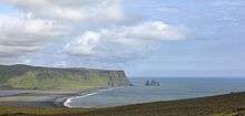
The view from Dyrhólaey is broad: To the north is to be seen the big glacier Mýrdalsjökull. To the east, the black lava columns of the Reynisdrangar come out of the sea, and to the west the whole coastline in the direction of Selfoss is visible - depending on weather conditions. In front of the peninsula, there is a gigantic black arch of lava standing in the sea, which gave the peninsula its name (meaning: door hill island).[3]
In the summertime, many Atlantic puffins can be found nesting on the cliff faces of Dyrhólaey.[4]
See also
References
- ↑ Journey to the Center of the Earth: Chapter IX. Iceland! But What Next?
- ↑ Harlow, Cathy (2004). Iceland. Hunter Publishing, Inc. ISBN 9781843061342. Retrieved 23 May 2018.
- ↑ Dalton, Anthony (2003). Wayward Sailor: In Search of the Real Tristan Jones. McGraw Hill Professional. ISBN 9780071402514. Retrieved 23 May 2018.
- ↑ Evans, Andrew (2008). Iceland. Bradt Travel Guides. ISBN 9781841622156. Retrieved 23 May 2018.
External links
| Wikimedia Commons has media related to Dyrhólaey. |
Coordinates: 63°23′59″N 19°07′35″W / 63.39972°N 19.12639°W