| [3] |
Name on the Register |
Image |
Date listed[4] |
Location |
City or town |
Description |
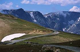
|---|
| 1 |
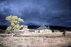
Absaroka Mountain Lodge |
|
October 30, 2003
(#03001105) |
1231 North Fork Highway
44°27′26″N 109°47′25″W / 44.457222°N 109.790278°W / 44.457222; -109.790278 (Absaroka Mountain Lodge) |
Cody |
|
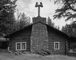
| 2 |
Anderson Lodge |
|
September 14, 1987
(#87001548) |
Greybull Ranger District, Shoshone National Forest
44°06′06″N 109°25′56″W / 44.101667°N 109.432222°W / 44.101667; -109.432222 (Anderson Lodge) |
Meeteetse |
|
| 3 |
Quintin Blair House |
|
September 27, 1991
(#91000998) |
5588 Greybull Highway
44°30′18″N 109°02′13″W / 44.505°N 109.036944°W / 44.505; -109.036944 (Quintin Blair House) |
Cody |
|
| 4 |
Buffalo Bill Boyhood Home |
|
June 5, 1975
(#75001906) |
720 Sheridan Ave.
44°31′11″N 109°04′27″W / 44.519722°N 109.074167°W / 44.519722; -109.074167 (Buffalo Bill Boyhood Home) |
Cody |
|
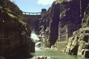
| 5 |
Buffalo Bill Dam |
|
August 12, 1971
(#71000890) |
7 miles west of Cody
44°30′05″N 109°10′57″W / 44.501389°N 109.1825°W / 44.501389; -109.1825 (Buffalo Bill Dam) |
Cody |
|
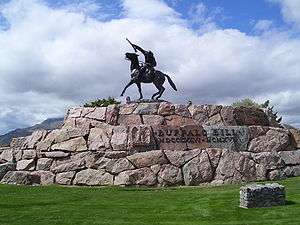
| 6 |
Buffalo Bill Statue |
|
December 31, 1974
(#74002319) |
720 Sheridan Ave.
44°31′33″N 109°04′26″W / 44.525833°N 109.073889°W / 44.525833; -109.073889 (Buffalo Bill Statue) |
Cody |
|
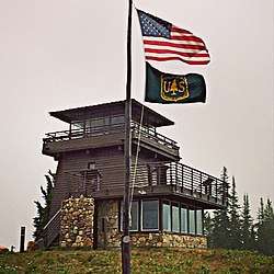
| 7 |
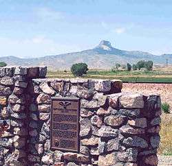
Clay Butte Lookout |
|
January 8, 2014
(#13001065) |
Approx. 1/2 mi. N. of jct. of US 212 and FS Rd. 142
44°56′40″N 109°37′36″W / 44.944392°N 109.626573°W / 44.944392; -109.626573 (Clay Butte Lookout) |
Clark vicinity |
Fire lookout tower built 1941-43, started by the Civilian Conservation Corps |
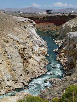
| 8 |
Colter's Hell |
|
August 14, 1973
(#73001937) |
West of Cody on U.S. Route 14
44°30′53″N 109°07′02″W / 44.514722°N 109.117222°W / 44.514722; -109.117222 (Colter's Hell) |
Cody |
A square mile of steam vents and hot springs on the Shoshone River. When John Colter saw it in 1807, it had active geysers. His account of that visit was the first description by a white man of a place in Wyoming.[5] |
| 9 |
Dead Indian Campsite |
|
May 3, 1974
(#74002030) |
Sunlight Basin Road
Address Restricted
|
Cody |
|
| 10 |
Downtown Cody Historic District |
|
August 15, 1983
(#83003361) |
1155 to 1313 and 1192 to 1286 Sheridan Ave.
44°31′34″N 109°04′21″W / 44.526111°N 109.0725°W / 44.526111; -109.0725 (Downtown Cody Historic District) |
Cody |
|
| 11 |
Elephant Head Lodge |
|
October 30, 2003
(#03001107) |
1170 North Fork Highway
44°27′18″N 109°48′13″W / 44.455°N 109.803611°W / 44.455; -109.803611 (Elephant Head Lodge) |
Cody |
|
| 12 |
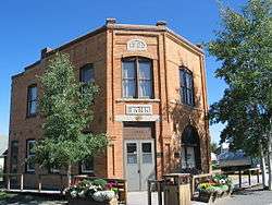
First National Bank of Meeteetse |
|
September 5, 1990
(#90001388) |
1033 Park Ave.
44°09′08″N 108°51′28″W / 44.152222°N 108.857778°W / 44.152222; -108.857778 (First National Bank of Meeteetse) |
Meeteetse |
|
| 13 |
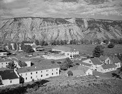
Fort Yellowstone |
|
July 31, 2003
(#03001032) |
Mammoth Hot Springs and Norris, Wyoming; Gardiner, Montana, near Buffalo Lake, Idaho
44°58′30″N 110°41′53″W / 44.975°N 110.698056°W / 44.975; -110.698056 (Fort Yellowstone) |
Mammoth Hot Springs |
|
| 14 |
Goff Creek Lodge |
|
October 30, 2003
(#03001108) |
995 E. Yellowstone Highway
44°27′19″N 109°50′12″W / 44.455278°N 109.836667°W / 44.455278; -109.836667 (Goff Creek Lodge) |
Cody |
|
| 15 |
Grand Loop Road Historic District |
|
December 23, 2003
(#03001345) |
Grand Loop Rd.
44°38′16″N 110°36′54″W / 44.637778°N 110.615°W / 44.637778; -110.615 (Grand Loop Road Historic District) |
Yellowstone National Park |
|
| 16 |
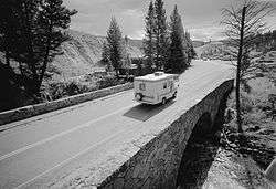
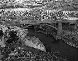
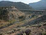
Hayden Arch Bridge |
|
February 22, 1985
(#85000430) |
Old US Routes 14/16 (Cody Yellowstone Highway)
44°30′37″N 109°08′48″W / 44.510278°N 109.146667°W / 44.510278; -109.146667 (Hayden Arch Bridge) |
Cody |
|
| 17 |
Heart Mountain Relocation Center |
|
December 19, 1985
(#85003167) |
½ mile from Wyoming Alt. 14 between Cody and Powell/1500 Road 19
44°40′14″N 108°56′35″W / 44.670556°N 108.943056°W / 44.670556; -108.943056 (Heart Mountain Relocation Center) |
Ralston |
|
| 18 |
Horner Site |
|
October 15, 1966
(#66000758) |
On a bluff overlooking the confluence of Sage Creek and the Shoshone River, 5 miles (8.0 km) east of Cody[6]
44°33′21″N 108°59′39″W / 44.5558°N 108.9942°W / 44.5558; -108.9942 (Horner Site) |
Cody |
|
| 19 |
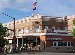
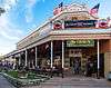
Irma Hotel |
|
April 3, 1973
(#73001936) |
1192 Sheridan Ave.
44°31′35″N 109°03′26″W / 44.526389°N 109.057222°W / 44.526389; -109.057222 (Irma Hotel) |
Cody |
|
| 20 |
Lamar Buffalo Ranch |
|
December 7, 1982
(#82001835) |
East of Mammoth Hot Springs on Northeast Entrance Rd.
44°53′32″N 110°14′23″W / 44.892222°N 110.239722°W / 44.892222; -110.239722 (Lamar Buffalo Ranch) |
Mammoth Hot Springs |
|
| 21 |
Mammoth Hot Springs Historic District |
|
March 20, 2002
(#02000257) |
North Entrance Rd. and Mammoth-Norris Rd.
44°58′37″N 110°41′52″W / 44.976944°N 110.697778°W / 44.976944; -110.697778 (Mammoth Hot Springs Historic District) |
Yellowstone National Park |
|
| 22 |
Mummy Cave |
|
February 18, 1981
(#81000611) |
U.S. Routes 14/16/20 near the eastern entrance of Yellowstone National Park[7]
44°27′39″N 109°44′10″W / 44.4607°N 109.736°W / 44.4607; -109.736 (Mummy Cave) |
Cody |
|
| 23 |
Norris Museum/Norris Comfort Station |
|
July 21, 1983
(#83003362) |
Grand Loop Rd.
44°43′34″N 110°42′21″W / 44.726111°N 110.705833°W / 44.726111; -110.705833 (Norris Museum/Norris Comfort Station) |
Yellowstone National Park |
|
| 24 |
Norris, Madison, and Fishing Bridge Museums |
|
May 28, 1987
(#87001445) |
Norris Geyser Basin, Madison Junction, and Fishing Bridge
44°38′38″N 110°38′49″W / 44.643889°N 110.646944°W / 44.643889; -110.646944 (Norris, Madison, and Fishing Bridge Museums) |
Yellowstone National Park |
|
| 25 |
North Entrance Road Historic District |
|
May 22, 2002
(#02000530) |
Yellowstone National Park
45°00′24″N 110°41′58″W / 45.006667°N 110.699444°W / 45.006667; -110.699444 (North Entrance Road Historic District) |
Yellowstone National Park |
|
| 26 |
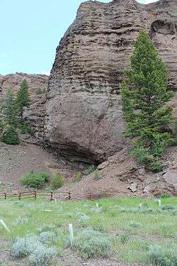
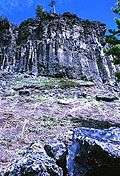
Obsidian Cliff |
|
June 19, 1996
(#96000973) |
Approximately 13 miles south of Mammoth; eastern side of U.S. Route 89, south of Obsidian Cliff Kiosk
44°48′28″N 110°41′52″W / 44.807778°N 110.697778°W / 44.807778; -110.697778 (Obsidian Cliff) |
Mammoth |
|
| 27 |
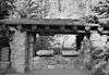
Obsidian Cliff Kiosk |
|
July 9, 1982
(#82001719) |
Yellowstone National Park
44°49′20″N 110°44′02″W / 44.822222°N 110.733889°W / 44.822222; -110.733889 (Obsidian Cliff Kiosk) |
Mammoth |
|
| 28 |
Pagoda Creek |
|
December 22, 2017
(#100001914) |
Address Restricted
|
Wapiti vicinity |
|
| 29 |
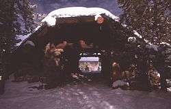
Pahaska Tepee |
|
March 20, 1973
(#73001938) |
2 miles east of eastern entrance to Yellowstone National Park on U.S. Route 14
44°30′10″N 109°57′42″W / 44.502778°N 109.961667°W / 44.502778; -109.961667 (Pahaska Tepee) |
Cody |
|
| 30 |
Pioneer School |
|
October 5, 1993
(#93001011) |
County Road 1-AG north of Badger Basin
44°58′23″N 109°05′00″W / 44.973056°N 109.083333°W / 44.973056; -109.083333 (Pioneer School) |
Clark |
|
| 31 |
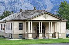
Ralston Community Clubhouse |
|
July 23, 1998
(#98000907) |
969 Carbon St.
44°43′43″N 108°52′01″W / 44.728611°N 108.866944°W / 44.728611; -108.866944 (Ralston Community Clubhouse) |
Ralston |
|
| 32 |
Red Lodge-Cooke City Approach Road Historic District |
|
May 8, 2014
(#14000219) |
US 212
44°56′31″N 109°35′47″W / 44.941823°N 109.596287°W / 44.941823; -109.596287 (Red Lodge-Cooke City Approach Road Historic District) |
Red Lodge |
Extends into Carbon County, Montana and Park County, Montana |
| 33 |
Red Star Lodge and Sawmill |
|
October 30, 2003
(#03001106) |
349 Yellowstone Highway
44°29′49″N 109°56′04″W / 44.496944°N 109.934444°W / 44.496944; -109.934444 (Red Star Lodge and Sawmill) |
Cody |
|
| 34 |
Roosevelt Lodge Historic District |
|
April 4, 1983
(#83003363) |
Grand Loop Rd.
44°54′47″N 110°24′56″W / 44.913056°N 110.415556°W / 44.913056; -110.415556 (Roosevelt Lodge Historic District) |
Yellowstone National Park |
|
| 35 |
Stock Center |
|
January 1, 1976
(#76001960) |
836 Sheridan Ave.
44°31′31″N 109°04′11″W / 44.525278°N 109.069722°W / 44.525278; -109.069722 (Stock Center) |
Cody |
|
| 36 |
Paul Stock House |
|
January 27, 2000
(#99001727) |
1300 Sunset Dr.
44°31′24″N 109°04′50″W / 44.523333°N 109.080556°W / 44.523333; -109.080556 (Paul Stock House) |
Cody |
|
| 37 |
T E Ranch Headquarters |
|
April 3, 1973
(#73001939) |
30 miles southwest of Cody on South Fork Rd.
44°16′53″N 109°29′35″W / 44.281389°N 109.493056°W / 44.281389; -109.493056 (T E Ranch Headquarters) |
Cody |
|
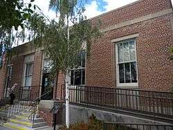
| 38 |
US Post Office-Powell Main |
|
May 22, 1987
(#87000787) |
270 N. Bent St.
44°45′19″N 108°45′27″W / 44.755278°N 108.7575°W / 44.755278; -108.7575 (US Post Office-Powell Main) |
Powell |
|
| 39 |
US Post Office-Yellowstone Main |
|
May 19, 1987
(#87000789) |
Mammoth, off Grand Loop Rd.
44°58′37″N 110°41′52″W / 44.976944°N 110.697778°W / 44.976944; -110.697778 (US Post Office-Yellowstone Main) |
Yellowstone National Park |
|
| 40 |
UXU Ranch |
|
May 24, 2003
(#03000581) |
1710 N. Fork Highway, Shoshone National Forest
44°09′18″N 109°43′15″W / 44.155°N 109.720833°W / 44.155; -109.720833 (UXU Ranch) |
Wapiti |
|
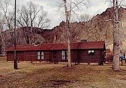
| 41 |
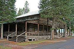
Wapiti Ranger Station |
|
October 15, 1966
(#66000759) |
Shoshone National Forest
44°27′57″N 109°36′58″W / 44.465833°N 109.616111°W / 44.465833; -109.616111 (Wapiti Ranger Station) |
Wapiti |
|

%2C_Le_Claire%2C_Scott%2C_IA.jpg)