| [3] |
Name on the Register |
Image |
Date listed[4] |
Location |
City or town |
Description |
|---|
| 1 |
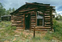
Atlantic City Mercantile |
|
April 25, 1985
(#85000869) |
Rt. 62, Box 260
42°29′15″N 108°43′47″W / 42.4875°N 108.729722°W / 42.4875; -108.729722 (Atlantic City Mercantile) |
Atlantic City |
|
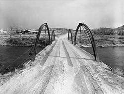
| 2 |
BMU Bridge over Wind River |
|
February 22, 1985
(#85000421) |
Wyoming Highway 132
43°08′36″N 108°42′29″W / 43.143333°N 108.708056°W / 43.143333; -108.708056 (BMU Bridge over Wind River) |
Ethete |
Replaced |
| 3 |
Brooks Lake Lodge |
|
September 29, 1982
(#82004333) |
Lower Brooks Lake-Shoshone National Forest
43°44′47″N 110°00′23″W / 43.746389°N 110.006389°W / 43.746389; -110.006389 (Brooks Lake Lodge) |
Dubois |
|
| 4 |
Carpenter Hotel Historic District |
|
December 12, 2012
(#12001054) |
290 Atlantic City Rd.
42°29′40″N 108°43′59″W / 42.49437°N 108.73315°W / 42.49437; -108.73315 (Carpenter Hotel Historic District) |
Atlantic City |
|
| 5 |
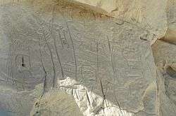
Castle Gardens Petroglyph Site |
|
April 16, 1969
(#69000189) |
Castle Garden Road
42°55′45″N 107°36′49″W / 42.9293°N 107.6137°W / 42.9293; -107.6137 (Castle Gardens Petroglyph Site) |
Moneta |
|
| 6 |
CM Ranch and Simpson Lake Cabins |
|
September 15, 1992
(#92001249) |
State Fish Hatchery Rd. south of Dubois off U.S. Route 287
43°28′08″N 109°39′03″W / 43.468889°N 109.650833°W / 43.468889; -109.650833 (CM Ranch and Simpson Lake Cabins) |
Dubois |
|
| 7 |
Dean Decker Site (48FR916; 48SW541) |
|
March 12, 1986
(#86000354) |
Address restricted
|
Honeycomb Buttes |
Extends into Sweetwater County |
| 8 |
Delfelder Schoolhouse |
|
March 29, 1978
(#78002826) |
North of Riverton off U.S. Route 26
43°05′01″N 108°21′37″W / 43.083611°N 108.360278°W / 43.083611; -108.360278 (Delfelder Schoolhouse) |
Riverton |
|
| 9 |
Diamond A Ranch |
|
August 19, 1991
(#91001026) |
Off U.S. Routes 26/287 northeast of Whiskey Mountain
43°28′43″N 109°30′09″W / 43.478611°N 109.5025°W / 43.478611; -109.5025 (Diamond A Ranch) |
Dubois |
|
| 10 |
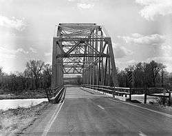
ELS Bridge over Big Wind River |
|
February 22, 1985
(#85000420) |
County Road CN10-21
43°33′06″N 109°40′45″W / 43.551667°N 109.679167°W / 43.551667; -109.679167 (ELS Bridge over Big Wind River) |
Dubois |
|
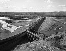
| 11 |
ELY Wind River Diversion Dam Bridge |
|
February 22, 1985
(#85000422) |
County Road CN10-24
43°13′30″N 108°57′16″W / 43.225°N 108.954444°W / 43.225; -108.954444 (ELY Wind River Diversion Dam Bridge) |
Morton |
|
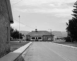
| 12 |
Fort Washakie Historic District |
|
April 16, 1969
(#69000188) |
Wind River Indian Reservation on U.S. Route 287
43°00′22″N 108°52′59″W / 43.006111°N 108.883056°W / 43.006111; -108.883056 (Fort Washakie Historic District) |
Fort Washakie |
|
| 13 |
Green Mountain Arrow Site |
|
March 12, 1986
(#86000351) |
Address Restricted
|
Stratton Rim |
|
| 14 |
Hamilton City |
|
June 4, 1980
(#80004047) |
Northeast of Atlantic City
42°31′58″N 108°40′55″W / 42.532778°N 108.681944°W / 42.532778; -108.681944 (Hamilton City) |
Atlantic City |
|
| 15 |
High Rise Village |
|
July 23, 2013
(#13000542) |
Address Restricted
|
Dubois vicinity |
|
| 16 |
Jackson Park Town Site Addition Brick Row |
|
February 27, 2003
(#03000083) |
615, 635, and 677 S. 3rd St.
42°49′39″N 108°43′58″W / 42.8275°N 108.732778°W / 42.8275; -108.732778 (Jackson Park Town Site Addition Brick Row) |
Lander |
|
| 17 |
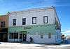
C. H. King Company and First National Bank of Shoshoni |
|
September 8, 1994
(#94001135) |
127 Main St.
43°14′06″N 108°06′25″W / 43.235°N 108.106944°W / 43.235; -108.106944 (C. H. King Company and First National Bank of Shoshoni) |
Shoshoni |
Also known as Old Yellowstone Drug |
| 18 |
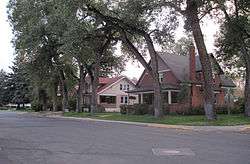
Lander Downtown Historic District |
|
May 5, 1987
(#87000700) |
Main St. between 2nd and 4th Sts.
42°49′59″N 108°43′55″W / 42.833056°N 108.731944°W / 42.833056; -108.731944 (Lander Downtown Historic District) |
Lander |
|
| 19 |
Helen Lookingbill Site |
|
March 20, 2013
(#13000102) |
Address Restricted
|
Dubois |
|
| 20 |
Quien Sabe Ranch |
|
April 18, 1991
(#91000434) |
Quien Sabe Ranch Rd., 18 mi (29 km) northeast of Shoshoni
43°23′40″N 107°59′35″W / 43.394444°N 107.993056°W / 43.394444; -107.993056 (Quien Sabe Ranch) |
Shoshoni |
|
| 21 |
Riverton Railroad Depot |
|
May 22, 1978
(#78002827) |
1st and Main Sts.
43°01′28″N 108°23′24″W / 43.024444°N 108.39°W / 43.024444; -108.39 (Riverton Railroad Depot) |
Riverton |
|
| 22 |
Shoshone-Episcopal Mission |
|
April 11, 1973
(#73001931) |
3 mi (4.8 km) southwest of Fort Washakie on Moccasin Lake Rd.
42°59′09″N 108°54′17″W / 42.985833°N 108.904722°W / 42.985833; -108.904722 (Shoshone-Episcopal Mission) |
Fort Washakie |
|
| 23 |
South Pass |
|
October 15, 1966
(#66000754) |
About 10 mi (16 km) southwest of South Pass City on Wyoming Highway 28
42°22′12″N 108°54′49″W / 42.37°N 108.913611°W / 42.37; -108.913611 (South Pass) |
South Pass City |
|
| 24 |
South Pass City Historic District |
|
February 26, 1970
(#70000670) |
South Pass Rd.; also 675 Atlantic City Rd.
42°28′16″N 108°48′19″W / 42.471111°N 108.805278°W / 42.471111; -108.805278 (South Pass City Historic District) |
South Pass City |
Originally listed simply as "South Pass City"; name changed in 2012 |
| 25 |
Split Rock Prehistoric Site |
|
May 4, 1987
(#87000662) |
Address Restricted
|
Split Rock Ranch |
|
| 26 |
St. Michael's Mission |
|
June 21, 1971
(#71000886) |
In Ethete
43°01′30″N 108°46′22″W / 43.025°N 108.772778°W / 43.025; -108.772778 (St. Michael's Mission) |
Ethete |
|
| 27 |
T Cross Ranch Rural Historic District |
|
April 11, 2008
(#07000371) |
Address Restricted
|
Dubois |
|
| 28 |
Torrey Lake Club/Ranch Historic District |
|
August 12, 1991
(#91000999) |
Along the western shores of Lake Julia, Torrey Lake, and Ring Lake
43°27′38″N 109°33′21″W / 43.460556°N 109.555833°W / 43.460556; -109.555833 (Torrey Lake Club/Ranch Historic District) |
Dubois |
|
| 29 |
Torrey Lake Petroglyph District |
|
October 4, 1993
(#93000983) |
Address Restricted
|
Dubois |
|
| 30 |
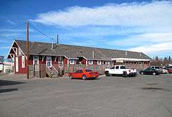
Twin Pines Lodge and Cabin Camp |
|
December 10, 1993
(#93001382) |
218 W. Ramshorn
43°32′01″N 109°38′04″W / 43.533611°N 109.634444°W / 43.533611; -109.634444 (Twin Pines Lodge and Cabin Camp) |
Dubois |
|
| 31 |
Union Pass |
|
April 16, 1969
(#69000367) |
On the Continental Divide in Teton National Forest
43°28′54″N 109°52′24″W / 43.481667°N 109.873333°W / 43.481667; -109.873333 (Union Pass) |
Dubois |
|
| 32 |
US Post Office and Courthouse-Lander Main |
|
May 19, 1987
(#87000782) |
177 N. 3rd St.
42°50′02″N 108°43′50″W / 42.833889°N 108.730556°W / 42.833889; -108.730556 (US Post Office and Courthouse-Lander Main) |
Lander |
|
| 33 |
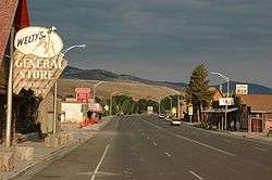
Welty's General Store |
|
November 15, 1979
(#79003680) |
220 Ramshorn St.
43°32′01″N 109°37′59″W / 43.533611°N 109.633056°W / 43.533611; -109.633056 (Welty's General Store) |
Dubois |
|
| 34 |
Wind River Agency Blockhouse |
|
December 23, 2000
(#00001589) |
Address Restricted
|
Fort Washakie |
|


.jpg)
.JPG)