National Register of Historic Places listings in McMinn County, Tennessee
Location of McMinn County in Tennessee
This is a list of the National Register of Historic Places listings in McMinn County, Tennessee.
This is intended to be a complete list of the properties and districts on the National Register of Historic Places in McMinn County, Tennessee, United States. Latitude and longitude coordinates are provided for many National Register properties and districts; these locations may be seen together in a map.[1]
There are 18 properties and districts listed on the National Register in the county.
| Anderson – Bedford – Benton – Bledsoe – Blount – Bradley – Campbell – Cannon – Carroll – Carter – Cheatham – Chester – Claiborne – Clay – Cocke – Coffee – Crockett – Cumberland – Davidson – Decatur – DeKalb – Dickson – Dyer – Fayette – Fentress – Franklin – Gibson – Giles – Grainger – Greene – Grundy – Hamblen – Hamilton – Hancock – Hardeman – Hardin – Hawkins – Haywood – Henderson – Henry – Hickman – Houston – Humphreys – Jackson – Jefferson – Johnson – Knox – Lake – Lauderdale – Lawrence – Lewis – Lincoln – Loudon – Macon – Madison – Marion – Marshall – Maury – McMinn – McNairy – Meigs – Monroe – Montgomery – Moore – Morgan – Obion – Overton – Perry – Pickett – Polk – Putnam – Rhea – Roane – Robertson – Rutherford – Scott – Sequatchie – Sevier – Shelby – Smith – Stewart – Sullivan – Sumner – Tipton – Trousdale – Unicoi – Union – Van Buren – Warren – Washington – Wayne – Weakley – White – Williamson – Wilson |
- This National Park Service list is complete through NPS recent listings posted October 11, 2018.[2]
Current listings
| [3] | Name on the Register[4] | Image | Date listed[5] | Location | City or town | Description |
|---|---|---|---|---|---|---|
| 1 | Beth Salem Presbyterian Church | 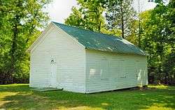 |
June 22, 2000 (#00000728) |
State Route 30 at Watson Rd. 35°23′26″N 84°34′09″W / 35.390556°N 84.569167°W |
Athens | Congregation founded in 1866; current building constructed in the 1920s |
| 2 | Elijah Cate House | March 25, 1982 (#82003993) |
West of Niota on State Route 1 35°30′32″N 84°33′48″W / 35.508889°N 84.563333°W |
Niota | ||
| 3 | James W. Chesnutt House | 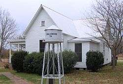 |
October 4, 2001 (#01001081) |
105 A S. Niota Rd. 35°25′31″N 84°29′17″W / 35.425278°N 84.488056°W |
Englewood | Maintained by Englewood Textile Museum |
| 4 | Samuel Cleage House | 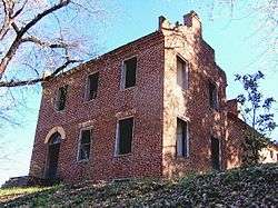 |
May 12, 1975 (#75002069) |
North of Athens on the Lee Highway 35°29′N 84°35′W / 35.49°N 84.58°W |
Athens | Not to be confused with Cleage's office in Athens |
| 5 | Clear Springs Cumberland Presbyterian Church | 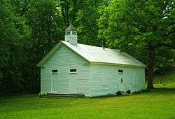 |
February 1, 2007 (#06001337) |
Clear Springs Rd. 35°16′13″N 84°41′22″W / 35.270278°N 84.689444°W |
Calhoun | |
| 6 | Etowah Carnegie Library | 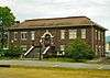 |
March 23, 2003 (#03000132) |
723-725 Ohio Ave. 35°19′26″N 84°31′34″W / 35.323889°N 84.526111°W |
Etowah | Currently functions as both a library and city hall |
| 7 | Etowah Depot | 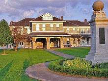 |
October 17, 1977 (#77001513) |
U.S. Route 411 35°19′24″N 84°31′28″W / 35.323333°N 84.524444°W |
Etowah | L&N train depot built in 1906 |
| 8 | Etowah Historic District | July 25, 1996 (#96000818) |
Roughly bounded by 5th St., Washington Ave., 11th St., and Indiana Ave. 35°19′30″N 84°31′49″W / 35.325°N 84.530278°W |
Etowah | ||
| 9 | First United Presbyterian Church | 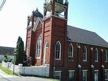 |
July 24, 2008 (#08000701) |
321 N. Jackson St. 35°26′48″N 84°35′47″W / 35.446667°N 84.596389°W |
Athens | |
| 10 | M.A. Helm House | December 18, 2013 (#13000951) |
149 Ralph Layman Rd. 35°23′40″N 84°36′38″W / 35.394444°N 84.610556°W |
Riceville | ||
| 11 | Alexander H. Keith House |  |
June 26, 1986 (#86001381) |
110 Keith Ln. 35°26′16″N 84°36′54″W / 35.437778°N 84.615°W |
Athens | Built in 1858; now a bed-and-breakfast |
| 12 | William Lowry House | 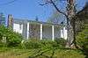 |
July 19, 1984 (#84003596) |
405 E. Madison Ave. 35°26′38″N 84°35′22″W / 35.443889°N 84.589444°W |
Athens | |
| 13 | McClatchey-Gettys Farm | December 28, 1982 (#82001731) |
South of Riceville on State Route 1 35°19′35″N 84°42′15″W / 35.326389°N 84.704167°W |
Riceville | ||
| 14 | Niota Depot | 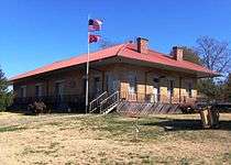 |
April 1, 1975 (#75002105) |
Main St. 35°30′54″N 84°32′46″W / 35.515000°N 84.546111°W |
Niota | Built in 1854; currently serves as Niota City Hall. |
| 15 | Old College | 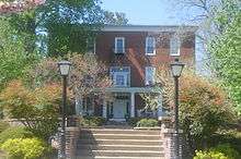 |
December 29, 1983 (#83004259) |
College St. 35°26′44″N 84°35′36″W / 35.445556°N 84.593333°W |
Athens | The original building of Athens Female College, now Tennessee Wesleyan College |
| 16 | Trew General Merchandise Store | 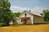 |
December 22, 1976 (#76002159) |
West of Delano at State Route 163 and Bowater Rd. 35°16′54″N 84°36′28″W / 35.281667°N 84.607778°W |
Delano | Operated as a general store from 1890 to 1990 |
| 17 | Trinity United Methodist Church | 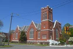 |
July 7, 2009 (#09000537) |
100 E. College St. 35°26′41″N 84°35′38″W / 35.444722°N 84.593889°W |
Athens | |
| 18 | John A. Turley House | 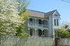 |
March 18, 1999 (#99000366) |
505 E. Madison St. 35°26′42″N 84°35′17″W / 35.445000°N 84.588056°W |
Athens |
See also
| Wikimedia Commons has media related to National Register of Historic Places in McMinn County, Tennessee. |
References
- ↑ The latitude and longitude information provided in this table was derived originally from the National Register Information System, which has been found to be fairly accurate for about 99% of listings. For about 1% of NRIS original coordinates, experience has shown that one or both coordinates are typos or otherwise extremely far off; some corrections may have been made. A more subtle problem causes many locations to be off by up to 150 yards, depending on location in the country: most NRIS coordinates were derived from tracing out latitude and longitudes from USGS topographical quadrant maps created under the North American Datum of 1927, which differs from the current, highly accurate WGS84 GPS system used by most on-line maps. Chicago is about right, but NRIS longitudes in Washington are higher by about 4.5 seconds, and are lower by about 2.0 seconds in Maine. Latitudes differ by about 1.0 second in Florida. Some locations in this table may have been corrected to current GPS standards.
- ↑ "National Register of Historic Places: Weekly List Actions". National Park Service, United States Department of the Interior. Retrieved on October 11, 2018.
- ↑ Numbers represent an ordering by significant words. Various colorings, defined here, differentiate National Historic Landmarks and historic districts from other NRHP buildings, structures, sites or objects.
- ↑ National Park Service (2008-04-24). "National Register Information System". National Register of Historic Places. National Park Service.
- ↑ The eight-digit number below each date is the number assigned to each location in the National Register Information System database, which can be viewed by clicking the number.
| Topics | |
|---|---|
| Lists by states |
|
| Lists by insular areas | |
| Lists by associated states | |
| Other areas | |
| |
Municipalities and communities of McMinn County, Tennessee, United States | ||
|---|---|---|
| Cities | ||
| Towns | ||
| CDP | ||
| Unincorporated communities |
| |
| Footnotes | ‡This populated place also has portions in an adjacent county or counties | |
This article is issued from
Wikipedia.
The text is licensed under Creative Commons - Attribution - Sharealike.
Additional terms may apply for the media files.