Riceville, Tennessee
| Riceville, Tennessee | |
|---|---|
| Census-designated place | |
 | |
 Riceville, Tennessee  Riceville, Tennessee | |
| Coordinates: 35°23′05″N 84°41′35″W / 35.38472°N 84.69306°WCoordinates: 35°23′05″N 84°41′35″W / 35.38472°N 84.69306°W | |
| Country | United States |
| State | Tennessee |
| County | McMinn |
| Area[1] | |
| • Total | 2.177 sq mi (5.64 km2) |
| • Land | 2.177 sq mi (5.64 km2) |
| • Water | 0 sq mi (0 km2) |
| Elevation | 837 ft (255 m) |
| Population (2010)[2] | |
| • Total | 670 |
| • Density | 310/sq mi (120/km2) |
| Time zone | UTC-5 (Eastern (EST)) |
| • Summer (DST) | UTC-4 (EDT) |
| Area code(s) | 423 |
| GNIS feature ID | 1299303[3] |
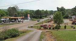
Riceville is an unincorporated community and census-designated place (CDP) in McMinn County, Tennessee, United States. It is located some sixty miles southwest of Knoxville, and midway between Knoxville and Chattanooga, and in closer proximity, between Athens and Calhoun .[4] Its population was 670 as of the 2010 census.[2]
References
- ↑ "US Gazetteer files: 2010, 2000, and 1990". United States Census Bureau. 2011-02-12. Retrieved 2011-04-23.
- 1 2 "American FactFinder". United States Census Bureau. Archived from the original on September 11, 2013. Retrieved 2011-05-14.
- ↑ U.S. Geological Survey Geographic Names Information System: Riceville, Tennessee
- ↑ Charles L. Bradshaw, POST YOUR PEG HIGH, Xulon Press, 2009, p. 22
External links
Municipalities and communities of McMinn County, Tennessee, United States | ||
|---|---|---|
| Cities | ||
| Towns | ||
| CDP | ||
| Unincorporated communities |
| |
| Footnotes | ‡This populated place also has portions in an adjacent county or counties | |
This article is issued from
Wikipedia.
The text is licensed under Creative Commons - Attribution - Sharealike.
Additional terms may apply for the media files.