National Register of Historic Places listings in Warren County, Tennessee
Location of Warren County in Tennessee
This is a list of the National Register of Historic Places listings in Warren County, Tennessee.
This is intended to be a complete list of the properties and districts on the National Register of Historic Places in Warren County, Tennessee, United States. Latitude and longitude coordinates are provided for many National Register properties and districts; these locations may be seen together in a map.[1]
There are 22 properties and districts listed on the National Register in the county.
| Anderson – Bedford – Benton – Bledsoe – Blount – Bradley – Campbell – Cannon – Carroll – Carter – Cheatham – Chester – Claiborne – Clay – Cocke – Coffee – Crockett – Cumberland – Davidson – Decatur – DeKalb – Dickson – Dyer – Fayette – Fentress – Franklin – Gibson – Giles – Grainger – Greene – Grundy – Hamblen – Hamilton – Hancock – Hardeman – Hardin – Hawkins – Haywood – Henderson – Henry – Hickman – Houston – Humphreys – Jackson – Jefferson – Johnson – Knox – Lake – Lauderdale – Lawrence – Lewis – Lincoln – Loudon – Macon – Madison – Marion – Marshall – Maury – McMinn – McNairy – Meigs – Monroe – Montgomery – Moore – Morgan – Obion – Overton – Perry – Pickett – Polk – Putnam – Rhea – Roane – Robertson – Rutherford – Scott – Sequatchie – Sevier – Shelby – Smith – Stewart – Sullivan – Sumner – Tipton – Trousdale – Unicoi – Union – Van Buren – Warren – Washington – Wayne – Weakley – White – Williamson – Wilson |
- This National Park Service list is complete through NPS recent listings posted October 11, 2018.[2]
Current listings
| [3] | Name on the Register[4] | Image | Date listed[5] | Location | City or town | Description |
|---|---|---|---|---|---|---|
| 1 | Black House | 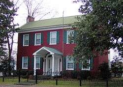 |
November 17, 1983 (#83004310) |
301 W. Main St. 35°40′52″N 85°46′34″W / 35.681111°N 85.776111°W |
McMinnville | |
| 2 | Cardwell Mountain | 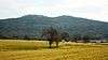 |
December 14, 1978 (#78002646) |
2.5 miles south-southeast of Union[6] 35°40′56″N 85°40′49″W / 35.6822°N 85.6803°W |
Union | Believed to have been a significant landmark among early Native Americans living in the area; Cumberland Caverns located on the mountain |
| 3 | City Cemetery | 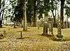 |
November 21, 2002 (#02001377) |
S. High St. 35°40′41″N 85°46′36″W / 35.678056°N 85.776667°W |
McMinnville | Established in 1813; last burial in 1938 |
| 4 | Falconhurst | 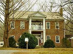 |
August 26, 1982 (#82004062) |
North of McMinnville on Faulkner Springs Rd. 35°42′57″N 85°46′03″W / 35.715833°N 85.7675°W |
McMinnville | Built by Asa Faulkner in 1850 |
| 5 | Clay Faulkner House | 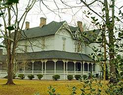 |
March 5, 1992 (#92000137) |
Junction of Faulkner Springs and Bluff Springs Rds. 35°43′01″N 85°45′42″W / 35.716944°N 85.761667°W |
McMinnville | Built in 1896 by entrepreneur Clay Faulkner (1845–1916); open to the public since 1993 as a museum under its original name, Falcon Rest Mansion |
| 6 | First Methodist Church | 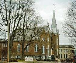 |
November 15, 2002 (#02001341) |
200 W. Main St. 35°40′54″N 85°46′29″W / 35.681667°N 85.774722°W |
McMinnville | Built in 1886; congregation dates to the 1830s |
| 7 | First Presbyterian Church | 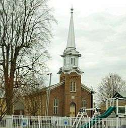 |
September 13, 1995 (#95001061) |
205 W. Main St. 35°40′52″N 85°46′31″W / 35.681111°N 85.775278°W |
McMinnville | Built in 1871; congregation founded 1839 |
| 8 | Great Falls Cotton Mill | 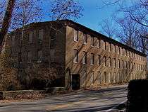 |
August 26, 1982 (#82004063) |
West of Rock Island off U.S. Route 70S 35°48′09″N 85°37′31″W / 35.8025°N 85.625278°W |
Rock Island | |
| 9 | Great Falls Hydroelectric Station | 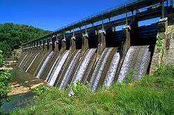 |
July 5, 1990 (#90001004) |
Off U.S. Route 70S at mile 91.1 on the Caney Fork 35°48′07″N 85°37′19″W / 35.801944°N 85.621944°W |
Rock Island | Extends into White County |
| 10 | William H. and Edgar Magness Community House and Library | 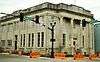 |
November 4, 1993 (#93001177) |
118 W. Main St. 35°40′53″N 85°46′27″W / 35.681389°N 85.774167°W |
McMinnville | Built by William H. Magness as a gift to the community in 1931; designed by George D. Waller |
| 11 | Martin-Miller Farm | 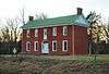 |
July 22, 2005 (#05000727) |
1597 Old Rock Island Rd. 35°44′26″N 85°40′19″W / 35.740556°N 85.671944°W |
Rowland Station | Includes the circa-1820 Rock Martin House |
| 12 | McMinnville Hydroelectric Station | 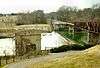 |
February 26, 1990 (#90000307) |
State Route 55 Business at the Barren Fork 35°40′29″N 85°46′36″W / 35.674722°N 85.776667°W |
McMinnville | Built in 1902 by the Walling Power and Light Company after an earlier dam at the site was destroyed by a flood |
| 13 | My Grandfather's House | 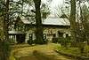 |
April 4, 1985 (#85000702) |
U.S. Route 70S 35°41′35″N 85°48′14″W / 35.693056°N 85.803889°W |
McMinnville | Log house built in 1817 by Abner Womack; originally located near Green's Crossroads |
| 14 | Myers Mound |  |
December 14, 1978 (#78002645) |
Address Restricted |
McMinnville | |
| 15 | Northcutt Plantation | .jpg) |
May 12, 1975 (#75001795) |
7 miles southwest of McMinnville off State Route 108 on Wheeler Lane 35°36′19″N 85°51′04″W / 35.605278°N 85.851111°W |
McMinnville | |
| 16 | Oakham | 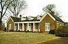 |
August 11, 1983 (#83003072) |
U.S. Route 70S 35°41′54″N 85°44′38″W / 35.698333°N 85.743889°W |
McMinnville | Built in the Federal style by Phillip Hoodenpyl for planter William Black c. 1835, later remodeled in Greek Revival style; used as Elizabeth J. Magness Home for the Aged and Indigent, 1930s–1980s |
| 17 | Philadelphia Church of Christ | 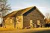 |
November 17, 1988 (#88002537) |
Vervilla Rd. 35°35′33″N 85°52′19″W / 35.5925°N 85.871944°W |
Vervilla | Officially called "Old Philadelphia Meeting House"; built 1830, restored 1985–1986 |
| 18 | Spring Street Service Station | 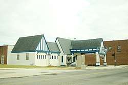 |
November 21, 2001 (#01001263) |
200 N. Spring St. 35°40′55″N 85°46′17″W / 35.681944°N 85.771389°W |
McMinnville | Built in the 1930s for Pure Oil, designed by Carl August Petersen; now an art gallery |
| 19 | Stone-Pennebaker House |  |
November 17, 1988 (#88002648) |
229 Towles Ave. 35°41′34″N 85°46′16″W / 35.692778°N 85.771111°W |
McMinnville | Built mid-19th century by Dillard Stone, later occupied by Samuel Pennebaker, who had married Stone's widow, Harriette; current address 116 Towles Ave. |
| 20 | US Post Office-Main | 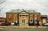 |
December 3, 1985 (#85003089) |
102 E. Court Sq.[7] 35°40′54″N 85°46′20″W / 35.6818°N 85.7723°W |
McMinnville | Built in 1931 and designed under the supervision of James A. Wetmore |
| 21 | Edgar Walling House | 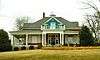 |
July 5, 1996 (#96000749) |
406 N. Spring St. 35°41′03″N 85°46′12″W / 35.684167°N 85.77°W |
McMinnville | Built in 1912 by local banker Edgar Walling |
| 22 | Joseph Daniel Walling House | 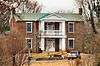 |
August 6, 1980 (#80003877) |
River Cliff and Old Viola Rds. 35°40′16″N 85°46′37″W / 35.671111°N 85.776944°W |
McMinnville | Greek Revival-style house built for Walling by Dillard George Stone in 1856 |
See also
| Wikimedia Commons has media related to National Register of Historic Places in Warren County, Tennessee. |
References
- ↑ The latitude and longitude information provided in this table was derived originally from the National Register Information System, which has been found to be fairly accurate for about 99% of listings. For about 1% of NRIS original coordinates, experience has shown that one or both coordinates are typos or otherwise extremely far off; some corrections may have been made. A more subtle problem causes many locations to be off by up to 150 yards, depending on location in the country: most NRIS coordinates were derived from tracing out latitude and longitudes from USGS topographical quadrant maps created under the North American Datum of 1927, which differs from the current, highly accurate WGS84 GPS system used by most on-line maps. Chicago is about right, but NRIS longitudes in Washington are higher by about 4.5 seconds, and are lower by about 2.0 seconds in Maine. Latitudes differ by about 1.0 second in Florida. Some locations in this table may have been corrected to current GPS standards.
- ↑ "National Register of Historic Places: Weekly List Actions". National Park Service, United States Department of the Interior. Retrieved on October 11, 2018.
- ↑ Numbers represent an ordering by significant words. Various colorings, defined here, differentiate National Historic Landmarks and historic districts from other NRHP buildings, structures, sites or objects.
- ↑ National Park Service (2008-04-24). "National Register Information System". National Register of Historic Places. National Park Service.
- ↑ The eight-digit number below each date is the number assigned to each location in the National Register Information System database, which can be viewed by clicking the number.
- ↑ Location derived from its GNIS feature record
- ↑ Address based on USPS website. Accessed April 10, 2016.
| Topics | |
|---|---|
| Lists by states |
|
| Lists by insular areas | |
| Lists by associated states | |
| Other areas | |
| |
Municipalities and communities of Warren County, Tennessee, United States | ||
|---|---|---|
| City | ||
| Towns | ||
| Unincorporated communities | ||
This article is issued from
Wikipedia.
The text is licensed under Creative Commons - Attribution - Sharealike.
Additional terms may apply for the media files.