| [3] |
Name on the Register |
Image |
Date listed[4] |
Location |
City or town |
Description |
|---|
| 1 |
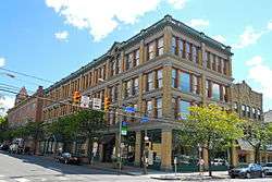
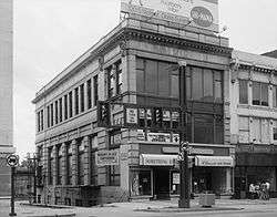
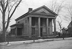
Ad-Lin Building |
|
November 5, 1987
(#87001969) |
600 Linden Street
41°24′29″N 75°39′41″W / 41.408056°N 75.661389°W / 41.408056; -75.661389 (Ad-Lin Building) |
Scranton |
|
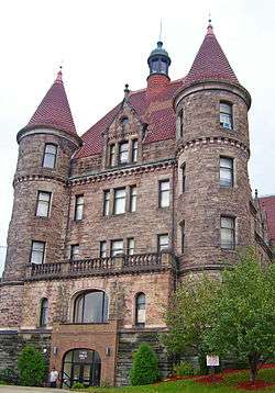
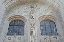
| 2 |
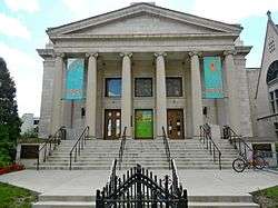
Albright Memorial Building |
|
May 22, 1978
(#78002411) |
North Washington Avenue and Vine Street
41°24′39″N 75°39′35″W / 41.410833°N 75.659722°W / 41.410833; -75.659722 (Albright Memorial Building) |
Scranton |
|
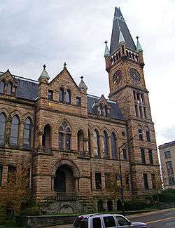
| 3 |
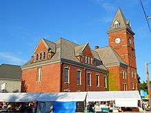
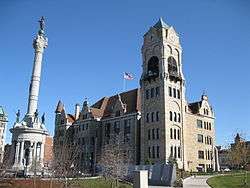
Carbondale City Hall and Courthouse |
|
January 6, 1983
(#83002248) |
One North Main Street
41°34′20″N 75°30′13″W / 41.572222°N 75.503611°W / 41.572222; -75.503611 (Carbondale City Hall and Courthouse) |
Carbondale |
|
| 4 |
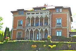
Joseph Cassese House |
|
October 24, 1997
(#97001258) |
1000 Clay Avenue
41°24′47″N 75°38′48″W / 41.413056°N 75.646667°W / 41.413056; -75.646667 (Joseph Cassese House) |
Scranton |
|
| 5 |
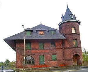
Central Railroad of New Jersey Freight Station |
|
August 1, 1979
(#79002250) |
602 West Lackawanna Avenue
41°24′42″N 75°40′16″W / 41.411667°N 75.671111°W / 41.411667; -75.671111 (Central Railroad of New Jersey Freight Station) |
Scranton |
|
| 6 |
Century Club of Scranton |
|
March 28, 1996
(#96000323) |
612 Jefferson Avenue
41°24′42″N 75°39′21″W / 41.411667°N 75.655833°W / 41.411667; -75.655833 (Century Club of Scranton) |
Scranton |
|
| 7 |
Delaware, Lackawanna and Western Railroad Station |
|
December 6, 1977
(#77001170) |
Lackawanna and Jefferson Avenues
41°24′19″N 75°39′43″W / 41.405278°N 75.661944°W / 41.405278; -75.661944 (Delaware, Lackawanna and Western Railroad Station) |
Scranton |
|
| 8 |
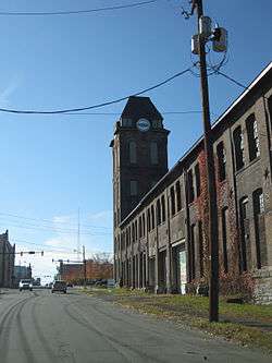
Delaware, Lackawanna and Western Railroad Yard-Dickson Manufacturing Co. Site |
|
November 21, 1990
(#90001739) |
Roughly bounded by Cliff Street, Lackawanna Avenue, Mattes Avenue, River Street and the Lackawanna River
41°24′23″N 75°40′09″W / 41.406389°N 75.669167°W / 41.406389; -75.669167 (Delaware, Lackawanna and Western Railroad Yard-Dickson Manufacturing Co. Site) |
Scranton |
|
| 9 |
Dickson Works |
|
May 14, 1979
(#79002251) |
225 Vine Street
41°24′49″N 75°39′45″W / 41.413611°N 75.6625°W / 41.413611; -75.6625 (Dickson Works) |
Scranton |
|
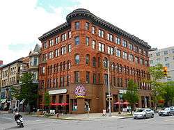
| 10 |
Dime Bank Building |
|
July 14, 1978
(#78002412) |
Wyoming Avenue and Spruce Street
41°24′30″N 75°39′56″W / 41.408333°N 75.665556°W / 41.408333; -75.665556 (Dime Bank Building) |
Scranton |
|
| 11 |
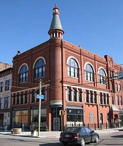
Finch Building |
|
June 14, 1976
(#76001644) |
424 Wyoming Avenue
41°24′42″N 75°39′43″W / 41.411667°N 75.661944°W / 41.411667; -75.661944 (Finch Building) |
Scranton |
|
| 12 |
First Church of Christ, Scientist |
|
May 9, 1988
(#88000467) |
520 Vine Street
41°24′32″N 75°39′38″W / 41.408889°N 75.660556°W / 41.408889; -75.660556 (First Church of Christ, Scientist) |
Scranton |
|
| 13 |
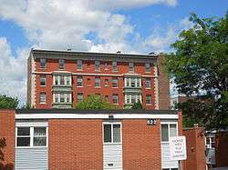
Florence Apartments |
|
January 5, 1984
(#84003412) |
643 Adams Avenue
41°24′46″N 75°39′24″W / 41.412778°N 75.656667°W / 41.412778; -75.656667 (Florence Apartments) |
Scranton |
|
| 14 |
Grand Army of the Republic Building |
|
May 17, 1984
(#84003416) |
303 Linden Street
41°24′39″N 75°39′55″W / 41.410833°N 75.665278°W / 41.410833; -75.665278 (Grand Army of the Republic Building) |
Scranton |
|
| 15 |
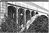
Harrison Avenue Bridge |
|
June 22, 1988
(#88000767) |
Legislative Route 5 over Legislative Route 35009, Par–Roaring Brook and railroad
41°24′00″N 75°39′06″W / 41.4°N 75.651667°W / 41.4; -75.651667 (Harrison Avenue Bridge) |
Scranton |
|
| 16 |
Lackawanna Avenue Commercial Historic District |
|
November 10, 1983
(#83004215) |
Roughly bounded by Adams, Franklin, Bogart Place, and Spruce Streets
41°24′27″N 75°39′55″W / 41.4075°N 75.665278°W / 41.4075; -75.665278 (Lackawanna Avenue Commercial Historic District) |
Scranton |
|
| 17 |
Lackawanna County Courthouse and John Mitchell Monument |
|
November 5, 1997
(#97001257) |
Bounded by Washington Avenue, Linden Street, Adams Avenue, and Spruce Street
41°24′29″N 75°39′46″W / 41.408056°N 75.662778°W / 41.408056; -75.662778 (Lackawanna County Courthouse and John Mitchell Monument) |
Scranton |
|
| 18 |
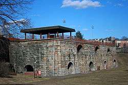
Lackawanna Iron and Coal Company Furnace |
|
September 6, 1991
(#91001126) |
159 Cedar Avenue
41°24′16″N 75°39′45″W / 41.404444°N 75.6625°W / 41.404444; -75.6625 (Lackawanna Iron and Coal Company Furnace) |
Scranton |
|
| 19 |
Lackawanna Mills and Scranton Button Historic District |
|
May 1, 2017
(#100000942) |
Bounded by Cedar & Remington Aves., Cherry & Brook Sts.
41°23′41″N 75°40′30″W / 41.394612°N 75.674983°W / 41.394612; -75.674983 (Lackawanna Mills and Scranton Button Historic District) |
Scranton |
|
| 20 |
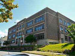
James Madison School |
|
June 24, 2009
(#09000463) |
528 Quincy Avenue
41°24′30″N 75°39′11″W / 41.408333°N 75.652917°W / 41.408333; -75.652917 (James Madison School) |
Scranton |
Educational Resources of Pennsylvania MPS |
| 21 |
Masonic Temple and Scottish Rite Cathedral |
|
November 7, 1997
(#97001259) |
416–420 North Washington Avenue
41°24′39″N 75°39′38″W / 41.410833°N 75.660556°W / 41.410833; -75.660556 (Masonic Temple and Scottish Rite Cathedral) |
Scranton |
|
| 22 |
Municipal Building and Central Fire Station, 340 |
|
September 11, 1981
(#81000544) |
North Washington Avenue and 518 Mulberry Street
41°24′36″N 75°39′41″W / 41.41°N 75.661389°W / 41.41; -75.661389 (Municipal Building and Central Fire Station, 340) |
Scranton |
|
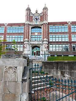
| 23 |
North Scranton Junior High School |
|
September 24, 1999
(#99001197) |
1539 North Main Avenue
41°25′42″N 75°38′51″W / 41.428333°N 75.6475°W / 41.428333; -75.6475 (North Scranton Junior High School) |
Scranton |
|
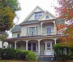
| 24 |
Terence V. Powderly House |
|
October 15, 1966
(#66000667) |
614 North Main Street
41°25′07″N 75°40′30″W / 41.418611°N 75.675°W / 41.418611; -75.675 (Terence V. Powderly House) |
Scranton |
|
| 25 |
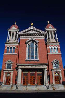
St. Peter's Cathedral Complex |
|
July 19, 1976
(#76001645) |
315 Wyoming Avenue
41°24′38″N 75°39′50″W / 41.410556°N 75.663889°W / 41.410556; -75.663889 (St. Peter's Cathedral Complex) |
Scranton |
|
| 26 |
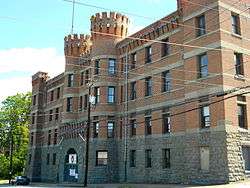
Scranton Armory |
|
December 22, 1989
(#89002081) |
900 Adams Avenue
41°24′55″N 75°39′10″W / 41.415278°N 75.652778°W / 41.415278; -75.652778 (Scranton Armory) |
Scranton |
|
| 27 |
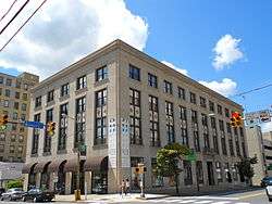
Scranton Chamber of Commerce Building |
|
September 8, 2011
(#11000647) |
426 Mulberry Street
41°24′38″N 75°39′42″W / 41.410417°N 75.661528°W / 41.410417; -75.661528 (Scranton Chamber of Commerce Building) |
Scranton |
|
| 28 |
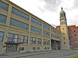
Scranton Lace Company |
|
April 16, 2012
(#12000221) |
1315 Meylert St.
41°25′36″N 75°39′34″W / 41.426736°N 75.659367°W / 41.426736; -75.659367 (Scranton Lace Company) |
Scranton |
|
| 29 |
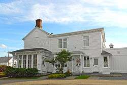
Silkman House |
|
December 18, 1978
(#78002413) |
2006 North Main Avenue
41°26′17″N 75°39′21″W / 41.438056°N 75.655833°W / 41.438056; -75.655833 (Silkman House) |
Scranton |
|
| 30 |
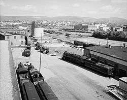
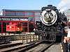
Steamtown National Historic Site |
|
October 30, 1986
(#01000282) |
150 South Washington Avenue
41°24′26″N 75°40′12″W / 41.407222°N 75.67°W / 41.407222; -75.67 (Steamtown National Historic Site) |
Scranton |
|
| 31 |
Tripp Family Homestead |
|
June 19, 1972
(#72001126) |
1101 North Main Avenue
41°25′36″N 75°40′12″W / 41.426667°N 75.67°W / 41.426667; -75.67 (Tripp Family Homestead) |
Scranton |
|
| 32 |
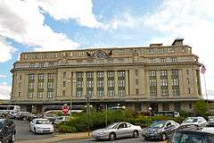
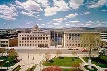
U.S. Post Office and Court House |
|
January 4, 2018
(#100001953) |
235 N Washington Ave.
41°24′31″N 75°39′47″W / 41.408605°N 75.662975°W / 41.408605; -75.662975 (U.S. Post Office and Court House) |
Scranton |
AKA the William J. Nealon Federal Building and United States Courthouse |
| 33 |
Waverly Historic District |
|
August 20, 2004
(#04000884) |
Roughly centered on Academy Street and Abington Road, including Carbondale Road and Beech, Cole, Church, and Dearborn Streets
41°31′38″N 75°42′18″W / 41.527222°N 75.705°W / 41.527222; -75.705 (Waverly Historic District) |
Waverly Township |
|
| 34 |
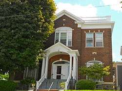
Roger Williams Public School No. 10 |
|
June 13, 1997
(#97000520) |
901 Prospect Avenue
41°23′38″N 75°39′57″W / 41.393889°N 75.665833°W / 41.393889; -75.665833 (Roger Williams Public School No. 10) |
Scranton |
|