Berkley Crossroads Historic District
|
Berkley Crossroads Historic District | |
 | |
  | |
| Location | Berkley Road and Castleton Rd., Darlington, Maryland |
|---|---|
| Coordinates | 39°39′46″N 76°12′19″W / 39.66278°N 76.20528°WCoordinates: 39°39′46″N 76°12′19″W / 39.66278°N 76.20528°W |
| Area | 150 acres (61 ha) |
| Built | 1752 |
| Architectural style | Colonial, Early Republic |
| NRHP reference # | 03000649[1] |
| Added to NRHP | July 17, 2003 |
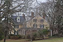
Berkley Crossroads Historic District is a historic district at Darlington, Harford County, Maryland, United States. It is a small rural crossroads community dating from the late 18th century through the early 20th century, and is one of the few remaining rural crossroads in Harford County. The entire area is agricultural in nature, and mostly consists of two- and three-story residences. The earliest structures, dating from the late 18th and early 19th century are of log construction, in whole or in part. It was also an important 19th century Free Black community.[2]
It was added to the National Register of Historic Places in 2003.[1]
References
- 1 2 National Park Service (2010-07-09). "National Register Information System". National Register of Historic Places. National Park Service.
- ↑ Christopher Weeks (June 2001). "National Register of Historic Places Registration: Berkley Crossroads Historic District" (PDF). Maryland Historical Trust. Retrieved 2016-01-01.
External links
- Berkley Crossroads Historic District, Harford County, including photo dated 2000, at Maryland Historical Trust
- Boundary Map of the Berkley Crossroads Historic District, Harford County, at Maryland Historical Trust
| Topics |  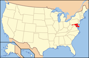 | |
|---|---|---|
| Lists by county | ||
| Lists by city | ||
| Other lists | ||
| ||
This article is issued from
Wikipedia.
The text is licensed under Creative Commons - Attribution - Sharealike.
Additional terms may apply for the media files.