Lower Deer Creek Valley Historic District
|
Lower Deer Creek Valley Historic District | |
 | |
  | |
| Nearest city | Darlington, Maryland |
|---|---|
| Coordinates | 39°36′43″N 76°14′5″W / 39.61194°N 76.23472°WCoordinates: 39°36′43″N 76°14′5″W / 39.61194°N 76.23472°W |
| Area | 15,210 acres (6,160 ha) |
| Architect | Cope, Walter; Multiple |
| Architectural style | Early Republic, Mid 19th Century Revival, Colonial Revival |
| NRHP reference # | 93001143[1] |
| Added to NRHP | November 3, 1993 |
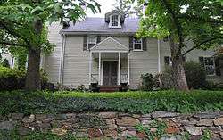
Lower Deer Creek Valley Historic District is a national historic district near Darlington, Harford County, Maryland, United States. It comprises approximately 15,020 acres (60.8 km2) in north central Harford County. The primary building material is stone taken from local quarries and used to construct houses, mills, schoolhouses, and churches. Also constructed of stone are many dependencies including springhouses, stables, tenant houses, meathouses, ice houses, and barns. The district's contributing standing structures date from the mid 18th century to the 1940s, and mostly built in vernacular styles. The valley contains approximately 350 separate historic properties.[2]
It was added to the National Register of Historic Places in 1993.[1]
References
- 1 2 National Park Service (2010-07-09). "National Register Information System". National Register of Historic Places. National Park Service.
- ↑ Christopher Weeks (May 1992). "National Register of Historic Places Registration: Lower Deer Creek Valley Historic District" (PDF). Maryland Historical Trust. Retrieved 2016-01-01.
External links
- Lower Deer Creek Valley Historic District, Harford County, including photo dated 1992, at Maryland Historical Trust
- Boundary Map of the Lower Deer Creek Valley Historic District, Harford County, at Maryland Historical Trust
| Topics |  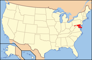 | |
|---|---|---|
| Lists by county | ||
| Lists by city | ||
| Other lists | ||
| ||
This article is issued from
Wikipedia.
The text is licensed under Creative Commons - Attribution - Sharealike.
Additional terms may apply for the media files.