Maryland Route 623
| ||||
|---|---|---|---|---|
 | ||||
| Route information | ||||
| Maintained by MDSHA | ||||
| Length | 7.26 mi[1] (11.68 km) | |||
| Existed | 1936 – present | |||
| Major junctions | ||||
| South end |
| |||
|
| ||||
| North end | SR 2043 near Flintville | |||
| Location | ||||
| Counties | Harford | |||
| Highway system | ||||
| ||||

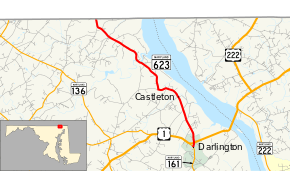
Maryland Route 623 (MD 623) is a state highway in the U.S. state of Maryland. The state highway runs 7.26 miles (11.68 km) from MD 161 in Darlington north to the Pennsylvania state line in Flintville. The first section of MD 623 was constructed in the mid-1930s south from the state line. The state highway was extended south to Darlington in two segments in the 1950s.
Route description
_at_Castleton_Road_northwest_of_Berkley_in_Harford_County%2C_Maryland.jpg)
MD 623 begins at an intersection with MD 161 (Darlington Road) in the village of Darlington. The state highway heads north as Castleton Road and quickly meets U.S. Route 1 (Conowingo Road). MD 623 passes through the community of Berkley centered on the highway's intersection with Berkley Road. The area is part of the Berkley Crossroads Historic District, which contains the Berkley School and the Rigbie House. MD 623 intersects Glen Cove Road and crosses Peddler Run in the village of Castleton before curving to the west. The state highway turns north onto Flintville Road, which heads through a forested area. MD 623 veers northwest and crosses Broad Creek, which is wide at this point from the backwater of the Susquehanna River from Conowingo Dam. The state highway passes through the hamlet of Flintville before reaching its northern terminus at the Pennsylvania state line.[1][2] Flintville Road continues north as SR 2043 in Peach Bottom Township in the southeast corner of York County.[3]
History
The first section of MD 623 was constructed along Flintville Road from the Pennsylvania state line to south of Susquehanna Hall Road around 1936.[4][5] Flintville Road was improved from Castleton Road to near Susquehanna Hall Road in 1950 and 1951.[6][7] MD 623 was extended south to Castleton Road in 1953 and to US 1 in 1956.[8][9] The highway's southern terminus was moved the short distance south to MD 161 in 1978.[10]
Junction list
The entire route is in Harford County.
| Location | mi[1] | km | Destinations | Notes | |
|---|---|---|---|---|---|
| Darlington | 0.00 | 0.00 | Southern terminus | ||
| 0.19 | 0.31 | ||||
| Flintville | 7.26 | 11.68 | SR 2043 north (Flintville Road) – Peach Bottom Township | Pennsylvania state line; northern terminus | |
| 1.000 mi = 1.609 km; 1.000 km = 0.621 mi | |||||
See also

References
- 1 2 3 Highway Information Services Division (December 31, 2013). Highway Location Reference. Maryland State Highway Administration. Retrieved 2011-03-01.
- Harford County (PDF)
- ↑ Google (2010-06-08). "Maryland Route 623" (Map). Google Maps. Google. Retrieved 2010-06-08.
- ↑ General Highway Map: York County, Pennsylvania (PDF) (Map) (2009 ed.). Pennsylvania Department of Transportation. Retrieved 2010-06-08.
- ↑ Tabler, H.E.; Wilkinson, C. Nice; Luthardt, Frank F. (December 4, 1936). Report of the State Roads Commission of Maryland (1935–1936 ed.). Baltimore: Maryland State Roads Commission. p. 81. Retrieved 2011-03-01.
- ↑ Maryland State Roads Commission (1938). Map of Maryland Showing State Road System (Map). Baltimore: Maryland State Roads Commission.
- ↑ Reindollar, Robert M.; George, Joseph M.; McCain, Russell H. (December 20, 1950). Report of the State Roads Commission of Maryland (1949–1950 ed.). Baltimore: Maryland State Roads Commission. p. 140. Retrieved 2011-03-01.
- ↑ McCain, Russell H.; Hall, Avery W.; Nichols, David M. (December 15, 1952). Report of the State Roads Commission of Maryland (1951–1952 ed.). Baltimore: Maryland State Roads Commission. p. 160. Retrieved 2011-03-01.
- ↑ Maryland State Roads Commission (1953). Maryland: Official Highway Map (Map). Baltimore: Maryland State Roads Commission.
- ↑ Maryland State Roads Commission (1956). Maryland: Official Highway Map (Map). Baltimore: Maryland State Roads Commission.
- ↑ Maryland State Highway Administration (1978). Maryland: Official Highway Map (Map). Baltimore: Maryland State Highway Administration.
External links
| Wikimedia Commons has media related to Maryland Route 623. |
Route map: