Castle Gardens Petroglyph Site
|
Castle Gardens Petroglyph Site | |
 | |
 | |
| Nearest city | Moneta, Wyoming |
|---|---|
| Coordinates | 42°55′45.48″N 107°36′49.32″W / 42.9293000°N 107.6137000°WCoordinates: 42°55′45.48″N 107°36′49.32″W / 42.9293000°N 107.6137000°W |
| Area | 3,840 acres (1,550 ha) |
| NRHP reference # | 69000189[1] |
| Added to NRHP | April 16, 1969 |
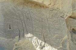
The Castle Gardens Petroglyph Site is a 6-mile (9.7 km) by 1-mile (1.6 km) region of vertical cliff faces in Fremont County, Wyoming, with extensive petroglyph images incised in the rock faces. The glyphs include images of water turtles and circular shields, as well as human and animal figures.[2] The figures with circular shields are particular to the area, and are known as Castle Gardens Shield style images. A consensus of researchers is that the figures were carved by Athabaskans related to the Navajo and Apache, some time between 1000 AD and 1250 AD[3] The site is being developed by the Bureau of Land Management, and may be visited.[4]
The site was placed on the National Register of Historic Places on April 16, 1969.[1]
References
- 1 2 National Park Service (2010-07-09). "National Register Information System". National Register of Historic Places. National Park Service.
- ↑ "Castle Garden Petroglyphs". Wyoming State Historic Preservation Office.
- ↑ "Castle Gardens Prehistoric Site". Wyoming State Historic Preservation Office.
- ↑ "Castle Gardens Petroglyph Site". Bureau of Land Management.
External links
- Castle Gardens Petroglyphs at the Bureau of Land Management
- Castle Gardens Petroglyphs at the Wyoming State Historic Presevation Office
- Castle Gardens at Wyoming History
This article is issued from
Wikipedia.
The text is licensed under Creative Commons - Attribution - Sharealike.
Additional terms may apply for the media files.