Nambucca Shire
| Nambucca Shire New South Wales | |||||||||||||||
|---|---|---|---|---|---|---|---|---|---|---|---|---|---|---|---|
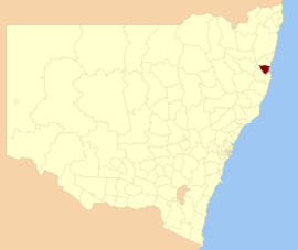 Location in New South Wales | |||||||||||||||
| Coordinates | 30°43′S 152°55′E / 30.717°S 152.917°ECoordinates: 30°43′S 152°55′E / 30.717°S 152.917°E | ||||||||||||||
| Population | 19,212 (2016 census)[1] | ||||||||||||||
| • Density | 12.885/km2 (33.373/sq mi) | ||||||||||||||
| Area | 1,491 km2 (575.7 sq mi) | ||||||||||||||
| Mayor | Rhonda Hoban (Independent) | ||||||||||||||
| Council seat | Macksville | ||||||||||||||
| Region | Mid North Coast | ||||||||||||||
| State electorate(s) | Oxley | ||||||||||||||
| Federal Division(s) | Cowper | ||||||||||||||
|
| |||||||||||||||
| Website | Nambucca Shire | ||||||||||||||
| |||||||||||||||
Nambucca Shire is a local government area in the mid north coast region of New South Wales, Australia.
The shire services an area of 1,491 square kilometres (576 sq mi) and is located adjacent to the Pacific Highway and the North Coast railway line. At the 2011 census, Nambucca Shire had a high proportion of Aboriginal and Torres Strait Islander people residing within its boundaries; being 7.3 per cent of the population, nearly treble the national and state averages of 2.5 per cent.[2] Within the Shire's boundaries is Bowraville, one of the most socially disadvantaged areas in Australia.[3]
The Mayor of the Nambucca Shire is Rhonda Hoban, an independent politician.[4]
Towns and localities
Towns and localities in the Nambucca Shire are:
- Allgomerra
- Bowraville
- Burrapine
- Congarinni
- Eungai Creek
- Eungai Rail
- Gumma
- Hyland Park
- Macksville
- Medlow
- Missabotti
- Nambucca Heads
- Newee Creek
- Scotts Head
- Talarm
- Tamban
- Taylors Arm
- Tewinga
- Thumb Creek
- Utungun
- Valla
- Valla Beach
- Warrell Creek
- Wirrimbi
- Yarranbella
Heritage listings
The Nambucca Shire has a number of heritage-listed sites, including:
- Macksville, North Coast railway: Macksville railway station[5]
Demographics
At the 2011 census, there were 18,644 people in the Nambucca Shire local government area, of these 48.8 per cent were male and 51.2 per cent were female. Aboriginal and Torres Strait Islander people made up 7.3 per cent of the population, nearly treble the national and state averages of 2.5 per cent. The median age of people in the Nambucca Shire was 49 years; some twelve years higher than the national median. Children aged 0 – 14 years made up 17.8 per cent of the population and people aged 65 years and over made up 24.4 per cent of the population. Of people in the area aged 15 years and over, 46.6 per cent were married and 16.4 per cent were either divorced or separated.[2]
Population growth in the Nambucca Shire between the 2001 census and the 2006 census was 1.34 per cent; and in the subsequent five years to the 2011 census was 4.17 per cent. When compared with total population growth of Australia for the same periods, being 5.78 per cent and 8.32 per cent respectively, population growth in the Nambucca Shire local government area was significantly lower than the national average.[6] The median weekly income for residents within the Nambucca Shire was significantly below the national average,[2][7] being one of the factors that place parts of the Nambucca Shire in an area of social disadvantage.[3]
At the 2011 Census, the proportion of residents in the Nambucca Shire local government area who stated their ancestry as Australian or Anglo-Saxon exceeded 82 per cent of all residents (national average was 65.2 per cent). In excess of 58 per cent of all residents in the Nambucca Shire nominated a religious affiliation with Christianity at the 2011 census, which was slightly higher than the national average of 50.2 per cent. Meanwhile, as at the census date, compared to the national average, households in the Nambucca Shire local government area had a significantly lower than average proportion (3.5 per cent) where two or more languages are spoken (national average was 20.4 per cent); and a significantly higher proportion (93.8 per cent) where English only was spoken at home (national average was 76.8 per cent). Of the 60 Australian residents who stated that they speak Gumbaynggir, an Australian Aboriginal language, over half live within the Nambucca Shire.[2]
| Selected historical census data for Nambucca local government area | ||||||
|---|---|---|---|---|---|---|
| Census year | 2001[6] | 2006[7] | 2011[2] | 2016[1] | ||
| Population | Estimated residents on census night | 17,660 | 17,897 | 18,644 | 19,212 | |
| LGA rank in terms of size within New South Wales | 71st | |||||
| % of New South Wales population | 0.27% | |||||
| % of Australian population | 0.09% | |||||
| Cultural and language diversity | ||||||
| Ancestry, top responses | Australian | 33.4% | ||||
| English | 32.6% | |||||
| Irish | 8.7% | |||||
| Scottish | 7.9% | |||||
| German | 3.0% | |||||
| Language, top responses (other than English) | German | 0.3% | ||||
| Gumbaynggir | n/c | |||||
| French | 0.1% | |||||
| Dutch | 0.2% | |||||
| Italian | 0.2% | |||||
| Religious affiliation | ||||||
| Religious affiliation, top responses | Anglican | 30.3% | ||||
| Catholic | 22.1% | |||||
| No Religion | 13.5% | |||||
| Presbyterian and Reformed | 6.2% | |||||
| Uniting Church | 6.8% | |||||
| Median weekly incomes | ||||||
| Personal income | Median weekly personal income | A$296 | A$377 | |||
| % of Australian median income | 63.5% | |||||
| Family income | Median weekly family income | A$562 | A$853 | |||
| % of Australian median income | 54.7% | |||||
| Household income | Median weekly household income | A$642 | A$700 | |||
| % of Australian median income | 54.8% | |||||
Council
Current composition and election method
Nambucca Shire Council is composed of nine Councillors, including the Mayor, for a fixed four-year term of office. The Mayor is directly elected while the eight other Councillors are elected proportionally as one entire ward. The most recent election was held on 10 September 2016, and the makeup of the Council is as follows:[4][8]
| Party | Councillors | |
|---|---|---|
| Independents and Unaffiliated | 8 | |
| Country Labor | 1 | |
| Total | 9 | |
The current Council, elected in 2016, in order of election, is:[8]
| Councillor | Party | Notes | |
|---|---|---|---|
| Rhonda Hoban | Independent | Mayor[4] | |
| John Ainsworth | Unaligned | ||
| Susan Jenvey | Country Labor | ||
| Martin Ballangarry | Independent | ||
| Brian Finlayson | Unaligned | ||
| Anne Smyth | Independent | ||
| Janine Reed | Unaligned | ||
| John Wilson | Independent | ||
| David Jones | Independent | ||
See also
References
- 1 2 Australian Bureau of Statistics (27 June 2017). "Nambucca (A)". 2016 Census QuickStats. Retrieved 7 July 2017.

- 1 2 3 4 5 Australian Bureau of Statistics (31 October 2012). "Nambucca (A)". 2011 Census QuickStats. Retrieved 1 December 2012.
- 1 2 Horin, Adele (26 February 2007). "Economic boom bypasses nation's poor". The Sydney Morning Herald. Retrieved 1 December 2012.
- 1 2 3 "Nambucca Shire Council - Mayoral Election". Local Government Election 2016. Electoral Commission of New South Wales. 19 September 2016. Retrieved 6 October 2016.
- ↑ "Macksville Railway Station group, New South Wales State Heritage Register (NSW SHR) Number H01184". New South Wales State Heritage Register. Office of Environment and Heritage. Retrieved 18 May 2018.
- 1 2 Australian Bureau of Statistics (9 March 2006). "Nambucca (A)". 2001 Census QuickStats. Retrieved 1 December 2012.
- 1 2 Australian Bureau of Statistics (25 October 2007). "Nambucca (A)". 2006 Census QuickStats. Retrieved 1 December 2012.
- 1 2 "Nambucca Shire Council - Summary of First Preference Votes for each Candidate". Local Government Election 2016. Electoral Commission of New South Wales. 19 September 2016. Retrieved 6 November 2016.