Hochgrat
| Hochgrat | |
|---|---|
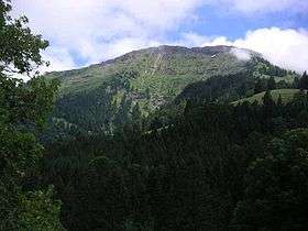 Hochgrat by Oberstaufen | |
| Highest point | |
| Elevation | 1,834 m (6,017 ft) |
| Prominence | 714 m (2,343 ft) |
| Isolation | 12.8 kilometres (8.0 mi) |
| Coordinates | 47°29′43.4″N 10°04′43″E / 47.495389°N 10.07861°ECoordinates: 47°29′43.4″N 10°04′43″E / 47.495389°N 10.07861°E |
| Geography | |
 Hochgrat Location in the Alps | |
| Location | Allgaeu, Bavaria, Germany |
| Parent range | Allgäu Alps |
| Climbing | |
| Easiest route | Road from valley station |
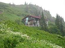
Staufner Haus of German Alpine Club Oberstaufen-Lindenberg
Hochgrat is a 1834 m high summit of the Allgäu Alps, highest mountain of the Nagelfluhkette (group of mountains consisting of conglomerate) and part of nature park Nagelfluhkette.
External links
This article is issued from
Wikipedia.
The text is licensed under Creative Commons - Attribution - Sharealike.
Additional terms may apply for the media files.