Nagahori Tsurumi-ryokuchi Line
| Osaka Metro Nagahori Tsurumi-ryokuchi Line | |||
|---|---|---|---|
|
| |||
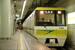 70 series linear motor EMU | |||
| Overview | |||
| Native name | 長堀鶴見緑地線 | ||
| Type | Rapid transit | ||
| System | Osaka Metro | ||
| Termini |
Taisho Kadoma-minami | ||
| Stations | 17 | ||
| Line number | 7 | ||
| Operation | |||
| Opened | March 31, 1990 | ||
| Operator(s) |
Osaka Metro (2018–present) Osaka Municipal Transportation Bureau (1990–2018) | ||
| Depot(s) | Tsurumi | ||
| Rolling stock | 70 series EMUs | ||
| Technical | |||
| Line length | 15.0 km (9.3 mi) | ||
| Track gauge | 1,435 mm (4 ft 8 1⁄2 in) standard gauge | ||
| Electrification | 1,500 V DC, overhead line | ||
| Operating speed | 70 km/h (43 mph) | ||
| |||

| Route map | ||||||||||||||||||||||||||||||||||||||||||||||||||||||||||||||||||||||||||||||||||||||||||||||||||||||||||||||||||||||||||||||||||||||||||||||||||||||||||||||||||||||||||||||||||||||||||||||||||||||||||||||||||||||||||||||||||||||||||||||||||||||||||||||||||||||||||||||||||||||||||||||||||||||||||||||||||||||||||||||||
|---|---|---|---|---|---|---|---|---|---|---|---|---|---|---|---|---|---|---|---|---|---|---|---|---|---|---|---|---|---|---|---|---|---|---|---|---|---|---|---|---|---|---|---|---|---|---|---|---|---|---|---|---|---|---|---|---|---|---|---|---|---|---|---|---|---|---|---|---|---|---|---|---|---|---|---|---|---|---|---|---|---|---|---|---|---|---|---|---|---|---|---|---|---|---|---|---|---|---|---|---|---|---|---|---|---|---|---|---|---|---|---|---|---|---|---|---|---|---|---|---|---|---|---|---|---|---|---|---|---|---|---|---|---|---|---|---|---|---|---|---|---|---|---|---|---|---|---|---|---|---|---|---|---|---|---|---|---|---|---|---|---|---|---|---|---|---|---|---|---|---|---|---|---|---|---|---|---|---|---|---|---|---|---|---|---|---|---|---|---|---|---|---|---|---|---|---|---|---|---|---|---|---|---|---|---|---|---|---|---|---|---|---|---|---|---|---|---|---|---|---|---|---|---|---|---|---|---|---|---|---|---|---|---|---|---|---|---|---|---|---|---|---|---|---|---|---|---|---|---|---|---|---|---|---|---|---|---|---|---|---|---|---|---|---|---|---|---|---|---|---|---|---|---|---|---|---|---|---|---|---|---|---|---|---|---|---|---|---|---|---|---|---|---|---|---|---|---|---|---|---|---|---|---|---|---|---|---|---|---|---|---|---|---|---|---|---|---|---|---|---|
| ||||||||||||||||||||||||||||||||||||||||||||||||||||||||||||||||||||||||||||||||||||||||||||||||||||||||||||||||||||||||||||||||||||||||||||||||||||||||||||||||||||||||||||||||||||||||||||||||||||||||||||||||||||||||||||||||||||||||||||||||||||||||||||||||||||||||||||||||||||||||||||||||||||||||||||||||||||||||||||||||
The Osaka Metro Nagahori Tsurumi-ryokuchi Line (長堀鶴見緑地線 Nagahori Tsurumi-ryokuchi-sen) is an underground rapid transit system in Osaka, Japan, operated by Osaka Metro. It was the first linear motor rapid transit line constructed in Japan (and the first outside North America, predated only by the Intermediate Capacity Transit System in Vancouver). Its official name is Rapid Electric Tramway Line No. 7 (高速電気軌道第7号線), while the Osaka Municipal Transportation Bureau refers to it as Osaka City Rapid Railway Line No. 7 (大阪市高速鉄道第7号線), and in MLIT publications, it is written as Line No. 7 (Nagahori Tsurumi-ryokuchi Line) (7号線(長堀鶴見緑地線)). Station numbers are indicated by the letter "N".
Line data
- The line is entirely underground, with no above-ground section.
- Block signalling: In-cab signalling
- Train protection system: CS-ATC, ATO
- Cars per train: 4 (1990 – present)
- Maximum possible cars per train (platform length): 8
Stations
Stopping patterns
All trains stop at every station on their route. Most trains operate between Taishō and Kadoma-minami; trains also operate shortened services which run from Taishō to either Shinsaibashi or Yokozutsumi during events held at Osaka Dome. Trains run every 2–4 minutes during peak hours, and every 7 minutes during off-peak hours.
Rolling stock
- 70 series four-car EMUs (since 1990)
Trains are automatically driven using ATO with a single driver on board to open and close the doors and to manually drive the train in emergency situations or when ATO breaks down or is not available. All trains are stored at Tsurumi-ryokuchi-kita depot (on the Imazatosuji Line) and maintained at Tsurumi workshop.
History
The line is named after Nagahori-dori, a major avenue which it follows through central Osaka, and the Tsurumi-ryokuchi, a park in northeastern Osaka which hosted the International Flower and Greenery Exposition in 1990. The line was built not only to provide access to the park during the exhibition, but also to relieve congestion from the Chūō Line. Its first segment opened on March 31, 1990 between Kyōbashi and Tsurumi-ryokuchi, at which time it was called the Tsurumi-ryokuchi Line (鶴見緑地線).
Under its original plan, the line would have provided access to the Osaka prefectural government offices near Osaka Castle. However, the presence of underground artifacts around the castle area made this plan impractical, and the line was thus shifted farther south, which also provided a better connection with the Chūō Line. On December 11, 1996, the line was opened as far as Shinsaibashi in downtown Osaka, and renamed the Nagahori Tsurumi-ryokuchi Line.
On August 29, 1997, the line was further extended westward to Taishō and eastward to Kadoma-minami.
Over the course of fiscal 2010, the 16 stations within Osaka City were outfitted with automatic platform gates, similar to those already in use on the Imazatosuji Line. At Taishō, the first station to be so equipped, the gates started operation on July 7, 2010. The final station, Kadoma-minami, had them installed over the course of October 2011, with operation starting on October 31.[1]
References
| Wikimedia Commons has media related to Nagahori Tsurumi-ryokuchi Line. |
- ↑ 平成23年10月末をもちまして 長堀鶴見緑地線の全17駅に可動式ホーム柵の設置が完了しました! [All 17 stations of Nagahori Tsurumi-ryokuchi Line equipped with platforms doors as of end of October 2011] (in Japanese). Japan: Osaka Municipal Transportation Bureau. October 31, 2011. Archived from the original on March 4, 2012. Retrieved April 20, 2012.