NCR Proposed Transport Plan
| National Capital Region India | |
|---|---|
| Government | |
| • Regional authority | National Capital Region Planning Board |
| Website | http://ncrpb.nic.in/ |
The NCR Planning Board had prepared a Functional Plan on Transport for National Capital Region with perspective year 2032, which is an Integrated Multimodal Transport Plan (IMTP). The Functional Plan was prepared after review of demand and supply of transport infrastructure in NCR. The Functional Plan was approved by the NCR Planning Board in November 2009. The Plan recommended an Integrated Multi-Modal Transportation System for NCR to improve the mobility of both people and goods. It also recommended systematic development of the Transport System for fast and efficient movement of traffic, particularly for commuter traffic and to achieve sustainable development of the region. The Plan comprises the following components:
| 1. Regional Rapid Transit System (RRTS) | 7. Bus Terminals |
| 2. New Rail Lines | 8. Logistic Hubs |
| 3. Regional Mass Rapid Transit System (MRTS) | 9. Integrated Freight Complexes |
| 4. Up-gradation of Roads | 10. Highway Facilities Centres, and |
| 5. Expressways | 11. Airports |
| 6. Bus Transport System |
The Plan was circulated for implementation to NCR participating State Governments in July 2010, February 2011 and December 2011. It was also circulated to the Ministry of Railways and the Ministry of Road Transport and Highways in February 2011 and in January 2012.
Objective
Objectives of the Transport Plan are: (i) to provide an efficient and economical rail- and road-based transportation system (including mass transport systems) well-integrated with the landuse patterns to support balanced regional development; (ii) to provide accessibility to all parts of the region and discourage transit of passengers and goods through the core area of NCT-Delhi by constructing Peripheral Expressways/ bypasses and thereby opening new areas for economic development; (iii) to provide a suitable public transport system in NCR to shift people from private transport to public transport, and (iv) to reduce vehicular air pollution.
Existing NCR transport system
The transport system of NCR consists of a road network and rail corridors catering to intra-city, inter-city commuters and long-distance traffic. The freight traffic is also substantial in the region which is mainly carried by road. NCR has a road network of about 36,305 km; a bus fleet of 58,300 buses (registered in NCR), a rail network of more than 1000 km; and an International Airport in Delhi.
Road Network
The existing road transport network is ‘radial’ in nature. It comprises Expressways, National Highways, State Highways, Major District Roads and Other District Roads. Ministry of Road Transport and Highways vide notification no. S.O.542(E) dated 05.03.2010 rationalized the numbering system of National Highways in India. The revised numbers as well as old number are given in the following table. The old numbers of National Highways are popular and recognizable.
| S.No. | Roads | Name of Roads with old numbers of National Highways | ! New Numbers of National Highways |
|---|---|---|---|
| i. | National Highways Converging to Meerut & Ghaziabad | NH-58 : Delhi-Meerut | NH-34 (Ghaziabad-Meerut) |
| ii. | Other National Highways in NCR | NH-119 : Meerut-Bijnor & NH-235:Meerut-Hapur-Bulandshahar | NH-34 & NH-334 |
Rail System
Indian Railways
The NCR rail network falls under three zonal railways (Northern, North-Western and North-Central) and five divisions. Six rail corridors converge to Delhi and three rail corridors converge to Ghaziabad. The zone-wise rail corridors are as under:
| Northern Railway zone | North Western Railway zone | North Central Railway zone |
|---|---|---|
| . Ambala railway division . Delhi railway division . Moradabad railway division | . Bikaner railway division | . Agra railway division |
| . Delhi-Faridabad-Palwal . Delhi-Gurgaon-Rewari . Delhi-Shakurbasti-Rohtak . Delhi-Sonepat-Panipat . Ghaziabad-Hapur-Garmukteshwar . Ghaziabad-Meerut . Meerut -Bulandshahr, Delhi (Shahadara)-Shamli-Saharanpur . Delhi-Ghaziabad | . Rewari-Bhiwadi-Alwar | . Palwal-Mathura . Ghaziabad-Khurja |
Intermediate Public Transport System (IPTS)
A large number of auto-rickshaws, electric rickshaws, and taxis operate in cities and towns within the NCR. On an average, an auto rickshaw carries 96 passengers per day and other vehicles like Rough Terrain Vehicle (RTVs) carry 114 passengers per day in NCR. The Intermediate Public Transport System (IPTS) suffers from many constraints like lack of terminal facilities, technological obsolescence, uneconomical fares, parking etc. There is an urgent need to facilitate growth and operation of IPTS within the NCR for providing last mile connectivity with MRTS, RRTS and Bus System.
Air Transport
Indira Gandhi International Airport
Indira Gandhi International Airport (IGIA) is the major airport in NCR. In terms of traffic volume, it is also the largest in India, and handles annually about 50 million (2016)[1] passengers and 0.56 million tonnes of cargo traffic (2011–12). Presently it has three operational runways with a peak hour handling capacity of 75 aircraft movements. There are three separate terminal areas for domestic passengers, international passengers, and cargo. The international passenger traffic at Delhi airport is 30% of the total passenger traffic. However, the international cargo traffic is 65% of the total cargo traffic. The Airport connects 60 destinations all over the globe through 51 international airlines. Of the passenger traffic, about 76% was generated within NCTD, 19% in NCR (excluding NCTD) and 5% beyond NCR (2007). Besides, it is expected to handle a large quantity of cargo on commissioning of Delhi Mumbai Industrial Corridor (DMIC). Indira Gandhi International Airport (IGIA), Delhi is the only commercial airport serving NCR. It is the second biggest in the country, handling a passenger traffic of 35.88 million and cargo traffic of 0.56 million tonnes, per annum. IGIA development, operation and management have been privatized. Air traffic is increasing at a high rate and it is estimated that Delhi airport would handle 82.7 million passengers by 2026. Based on the future growth of International Air traffic, a second International Airport in NCR may be developed.
Taj International Airport, Jewar
The Taj International Airport is a proposed international airport to be constructed in Jewar (56 kilometres (35 mi) from Noida) in Gautam Budh Nagar district of Uttar Pradesh. It is well connected with cities Agra, Bulandshahr, Greater Noida and Palwal. The Jewar airport is 85 kilometres (53 mi) from Indira Gandhi International Airport at Delhi and 280 kilometres (170 mi) from Hisar Airport. In May 2017, the airport was granted approval by the union government cabinet as the second airport for the NCR, to be built by 2022-23 with a capacity to handle 30-50 million passengers per year. This led to the protest from the politicians of Harayana for ignoring Hisar airport for the development.[2][3] In July 2017, the Union Chief Secretary for Aviation warned Uttar Pradesh government to expedite the planning process as Hisar Airport was also pushing for its competing union cabinet approval for another airport for the NCR, thus prolonging the return on investment for both airports due to still-feasible-but-diluted viability for both.[4]
Hisar International Airport
Hisar Airport is 5 km from the city center of NCR counter magnet city of Hisar and 160 km from IGI Airport at Delhi, and it is being promoted as a major integrated aviation hub with passenger, cargo, MRO and aviation industrial manufacturing facilities.[5] It was built in 1965 over 194 acres (79 ha). [6] In 2002, the Delhi Flying Club (DFC) shifted all its flying activities and aircraft to Hisar from Safdarjung Airport in Delhi.[7]
In 2011, the Government of Haryana invited Request for Qualification (RFQ) from commercial parties for the setting up of Integrated General Aviation hubs as public–private partnerships; with Hisar to be one of the airports to have a hub.[8] Expansion plans entail aircraft maintenance and Fixed Based Operator facilities.[9]
In August 2012, the Directorate General of Civil Aviation approved a state government plan to develop the airport to allow domestic airline services. Its 4,000 feet (1,219 m) runway will be extended to 6,000 feet (1,829 m), to accommodate turboprop aircraft such as the ATR 72 and jets such as the Boeing 737 and Airbus A320.[10] The airport's night flying equipment was also upgraded in 2012.[11] In December 2014, the Government of India commissioned a survey for upgrading Hisar airport (170 kilometres (110 mi) from Delhi) into an International airport; as Hisar is also a Counter Magnet City within the National Capital Region and the Delhi Mumbai Industrial Corridor Project (DMIC).[12] In July 2016, the Chief Minister and Defence Minister announced the commencement of the preparations to start the army airport and army air craft MRO (Maintenance, repair, and operations) at Hisar airport.[5] In 2016-17 budget, the Government of Haryana approved INR 50 crore (INR 500 million) for the development of Hisar airport into an international airport with passenger and cargo operations and 3000 acre MRO (Maintenance, repair, and operations) and Fixed-base Operations (FBO) aerospace industrial park and aviation hub to be developed by the Haryana State Industrial and Infrastructure Development Corporation Limited (HSIIDC).[13][14]
Meerut Airport
Meerut Airport aka B.R. Ambedkar Airport is situated at Partapur 9 km south of Meerut and 84 km north of IGI Delhi airport, in the Indian state of Uttar Pradesh. The airstrip, spread across 47 acres, is used for unscheduled flights. It has been suggested that the airport be upgraded as a second airport for Delhi. The Airports Authority of India (AAI) had proposed the development of the airport to provide better air connectivity in the western parts of the state, which had already been assessed for up-gradation to cater to scheduled operations. Union civil aviation minister Ajit Singh had urged the State government to handover the airstrip and an additional 427 acres to AAI for development. AAI presented a master plan to the state government in April 2012 seeking the transfer of the airstrip and additional land free of cost and free from all encumbrances. The state had earlier planned to build a new airport of international standard on same location. The state government had issued a notice for appointing a consultant to prepare a comprehensive feasibility project report, a bid document and the concession agreement for the proposed airport. The project would be implemented through public-private partnership on a design, build, finance, operate and transfer basis.
The State Government decided to have an international airport at Meerut based on a study conducted on the area’s traffic density. Following this, the ministry of civil aviation gave its in-principle approval. The need for a second airport on the fringes of the national capital region has been a long-standing demand of the Uttar Pradesh government, especially in view of the burgeoning air traffic at Delhi airport. The proposed airport will not only cater to the industrial towns of western Uttar Pradesh but would also be of immense relief to neighbouring Uttarakhand.
Bhiwadi Greenfield Airport
The proposed Bhiwadi Greenfield Airport, located at Bhiwadi between Rewari and Palwal, is being positioned as an alternative cargo and passenger airport for the Delhi and NCR by the Rajasthan government. Union government has not provided any approval yet.
Transport plan for NCR
Road System
Expressways, Regional Arterial and Regional Sub-Arterial Roads
Road Network forms the main component of Functional Plan on Transport for NCR-2032. A hierarchical classification comprising Regional Expressways, Regional Arterials, Regional Sub-Arterials, Regional Collectors / Distributors and Regional Access Roads is proposed. An extensive Regional Expressway Network extending over a length of 1107 km is proposed. At the second level, the existing radial National Highway corridors converging into Delhi and circular National Highways are proposed to be developed as part of Regional Arterials.
| S. No. | Expressways & Regional Expressways (Greenfield Alignments) | Length (Km) | ROW (m) | Type | Status |
|---|---|---|---|---|---|
| 1 | Ganga Expressway (within NCR)* | 65.0 | 100 | Greenfield | |
| 2 | Yamuna Expressway (within NCR)* | 65.0 | 100 | Greenfield | Operational |
| 3 | Western Peripheral Expressway | 135.6 | 100 | Greenfield | Operational 2017 |
| 4 | Eastern Peripheral Expressway | 136.0 | 100 | Greenfield | Operational 2017 |
| 5 | Panipat Elevated Expressway | 10.00 | 100 | Greenfield | Operational |
| 6 | Delhi - Ghaziabad | 15.34 | 100 | Greenfield | Awarded |
| 7 | Ghaziabad - Modinagar - Meerut | 33.21 | 100 | Greenfield | Awarded |
| 8 | Ghaziabad - Hapur | 25.90 | 100 | Greenfield | |
| 9 | Khurja - Bulandshahr - Hapur - Meerut | 72.44 | 100 | Greenfield | |
| 10 | Meerut - Baghpat - Sonepat | 37.48 | 100 | Greenfield | |
| 11 | Delhi - Baghpat | 36.28 | 100 | Greenfield | |
| 12 | Khurja - Jewar - Noida | 65 | 100 | Greenfield | |
| 13 | Delhi - Sonipat - Panipat (NH-1) | 69.75 | 100 | Greenfield | |
| 14 | Panipat - Rohtak (NH-71A) | 71 | 100 | Greenfield |
In addition to above, NHAI has recently proposed Delhi-Jaipur Expressway. On this Expressway, two spurs to connect Bhiwadi (38 km) and Jhajjar (25 km) are also proposed in NCR. The total length of Delhi-Jaipur Expressway in NCR including the two spurs will be 130 km. It is proposed to provide access to Behror from this expressway with a small spur. Government of Rajasthan has also proposed a 100 m wide link road of expressway standard between Neemrana and Bhiwadi. The proposed phase-wise programme for development of Regional Arterial roads in NCR is shown in Table. In case RoW is not available, elevated roads could be considered for increasing the number of lanes.
| S. No. | Regional Arterials | Length (km) | ROW (m) |
|---|---|---|---|
| 1 | Ghaziabad - Modinagar - Meerut (NH-58) | 53.0 | 60 |
| 2 | Hapur - Meerut (NH-235) | 33.0 | 60 |
| 3 | Meerut - Garhmukteshwar - Bulandshahr | 93.0 | 60 |
| 4 | Meerut - Muzaffarnagar (NH-58) (till NCR Border) | 19.0 | 60 |
| 5 | Meerut - Bahsuma (NH-119) | 50.0 | 60 |
| 6 | Loni - Baghpat - Baraut - Till NCR Border | 68.0 | 60 |
Regional Rail System
Regional Rapid Transit System (RRTS)
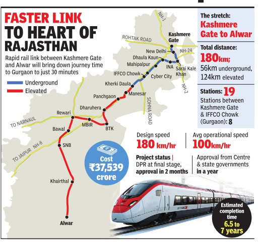
The rail-based inter- regional commuter demand in NCR is estimated to be 1.7 million passengers per day by 2032.
Phase I (Implementation)
NCRTC, AdIF (Spain) and SNCF (France) signed collaboration agreements and were already undertaking studies, planning and preparation (Dec 2017):[15][16][17]
- Speed (kmph): 180 design, 160 operational and 100 average speed
- Trains: 6 cars carrying total 1,154 passengers
- Frequency: 5 - 10 minutes
- Ease: Point-to-point trains, no change of trains
- Tracks: Underground and elevated
- Route & length: map (legends: BTK (Bhiwadi-Tapukara-Khushkhera), MBIR (Manesar Bawal Investment Region), SNB (Nangal Shahbazpur border), RGEU (Rajiv Gandhi Education & University) city)
| Sl No. | RRTS | Corridor | Starting Point (km)[15][16][17] | Length (km)[15][16][17] | Stations | Cost[15][16][17] | Construction Start[15][16][17] | Completion[15][16][17] | Notes[15][16][17] |
|---|---|---|---|---|---|---|---|---|---|
| 1. | Delhi-Meerut | Delhi-Ghaziabad-Meerut | Sarai Kale Khan | 82 km (51 mi) | 16 | ₹325,980 million (US$4.5 billion) | June 2018 | 2024 | Ground clearance, geo-technical investigations, detailed design, utility-shifting planning and traffic diversion planning are in progress (Dec 2017) |
| 2. | Delhi-Panipat | Delhi-Sonipat-Panipat | Sarai Kale Khan | 111 km (69 mi) | 16 | ₹300,000 million (US$4.2 billion) | 2019 | 2025 | Awaiting DPR approval (Dec 2017) |
| 3. | Delhi-Alwar | Delhi-Gurgaon-Rewari-Alwar | Sarai Kale Khan | 180 km (110 mi) | 17 | ₹375,390 million (US$5.2 billion) | 2019 | 2025 | Awaiting DPR approval (Dec 2017). |
| Total | 373 km (232 mi) | 49 |
Orbital Rail Corridor
In view of recommendations of the Functional Plan on Transport for NCR-2032, the earlier Orbital Corridor proposed in Regional Plan for NCR-2021 has been revised and following two Orbital Rail corridors have been proposed: i. Regional Orbital Rail Corridor (RORC) ii. Inner Regional Orbital Rail Corridor (IRORC)
Regional Orbital Rail Corridor (RORC)
The Regional Orbital Rail Corridor (RORC) connecting Panipat-Gohana-Rohtak-Jhajjar-Rewari-Palwal-Bhiwadi-Khurja-Bulandshahr-Hapur-Meerut-Panipat enables movement of passenger and goods at the regional level avoiding Delhi area. RORC also interconnects the Regional Centers which would increase their accessibility and potential for growth.
- Panipat-Rohtak line, via Panipat-Gohana-Rohtak, existing.
- Rohtak-Rewari line, via Rohtak-Jhajjar-Rewari, existing.
- Rewari-Khurja line, via Rewari-Palwal-Bhiwadi-Khurja, new rail line, survey completed.
- Khurja-Meerut line, via Khurja-Bulandshahr-Hapur-Meerut, existing.
- Meerut-Panipat line, new rail line, survey completed.
Inner Regional Orbital Rail Corridor (IRORC)
In addition to RORC, five following rail lines within NCR are proposed to strengthen the connectivity of the rail system which will form Inner Regional Orbital Rail Corridor (IRORC).
Other New Rail Line
The Sonepat-Jind line via Gohana is completed and trains are running on this rail track. The corridor-wise estimated passenger loading excluding freight traffic with implementation phasing of RORC, IRORC and new rail line is shown in Table
| New Rail Links | Length (KM) | Status |
|---|---|---|
| Panipat-Meerut line (IRORC)* | 110 km (68 mi) | |
| Meerut-Sonepat line via Baghtpat (IRORC) | 66 km (41 mi) | |
| Meerut-Hastinapur line | 45 km (28 mi) | |
| Khurja-Noida line | 65 km (40 mi) | |
| Bulandshahr-Chola line | 17 km (11 mi) |
See also
- Hisar Airport, at Hisar NCR counter-magnet city
- Meerut Airport, at Meerut city within NCR
- Taj International Airport, at Agra city within NCR
- National Capital Region Transport Corporation
References
- ↑ IGI first in India to cross 5cr flyer mark
- ↑ Centre has overlooked Haryana's interests: Deepinder Hooda , Catch news. 5 July 2017.
- ↑ "UP govt revives Jewar airport project, survey to start today". Daily News Analysis. Retrieved 14 May 2017.
- ↑ Aviation secy tells UP to form Jewar airport SPV, Yamuna Authority’s hands full, money Control News, 10 July 2017.
- 1 2 Panchkula to have military medical college, Publication: The Tribune newspaper, Publication Date: 4 July 2016, Access Date: 4 July 2016
- ↑ "Hisar jano" (PDF). Jambh Shakti Trust. Retrieved 23 May 2012.
- ↑ "Safdarjung airport flies into history". The Times of India. 5 April 2003. Retrieved 31 May 2012.
- ↑ http://haraviation.gov.in/ppp.htm
- ↑ "Archived copy" (PDF). Archived from the original (PDF) on 2 July 2013. Retrieved 27 June 2013.
- ↑ "Three airports ready to take off in Haryana". Times of India. 29 August 2012. Retrieved 6 September 2012.
- ↑ "Haryana to fly high with 3 new airports - The Times of India". The Times Of India.
- ↑ Hisar aerodrome being considered for international airport, says MLA - by HT Correspondent, Hindustan Times on 2 December 2014, www.hindustantimes.com Archived 11 December 2014 at the Wayback Machine.
- ↑ Haryana to develop international airport at Hisar, Published on March 2016
- ↑ State shelves Hisar airport cargo project, The Tribune, Punlished on 29 May 2015
- 1 2 3 4 5 6 7 , 1 Dec 2017.
- 1 2 3 4 5 6 7 On track: Direct trains on high-speed rail corridor to and from most NCR towns, Hindustan Times, 28 November 2017.
- 1 2 3 4 5 6 7 High speed rail link by 2023 to cut journey time to 30 minutes at 100 km/h between Kashmere Gate and Gurgaon, Economic Times, 23 April 2017.