N3 (South Africa)
| ||||
|---|---|---|---|---|
_with_labels.svg.png) | ||||
| Route information | ||||
| Maintained by SANRAL, N3TC, eThekwini Metropolitan Municipality | ||||
| Major junctions | ||||
| Southeast end | Pine Street/Commercial Road in Durban | |||
|
| ||||
| Northwest end |
| |||
| Location | ||||
| Major cities | Durban, Pietermaritzburg, Estcourt, Ladysmith, Harrismith, Heidelberg, Germiston, Johannesburg | |||
| Highway system | ||||
|
Numbered routes of South Africa
| ||||

The N3 is a national route in South Africa that connects Johannesburg and Durban,[1] respectively South Africa's largest and third-largest cities. Johannesburg is the financial and commercial heartland of South Africa, while Durban is South Africa's key port and one of the busiest ports in the Southern Hemisphere and is also a holiday destination. Durban is the port through which Johannesburg imports and exports most of its goods. As a result, the N3 is a very busy highway and has a high volume of traffic.
Route
The N3 is divided into 12 sections, starting with section 1 in Durban and ending with section 12 in Johannesburg. Between the two cities, the route passes the following towns and cities: Pietermaritzburg, Estcourt, Ladysmith, Harrismith, Heidelberg and Germiston. It no longer passes through any of these towns, as bypasses have been built around all of them. The last bypass that was built was around the town of Warden.
KwaZulu-Natal
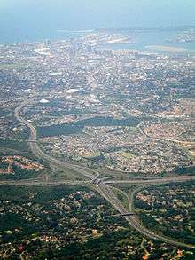
The N3 begins in the Durban Central Business District at Pine Street and Commercial Road as a dual-carriageway freeway and heads west, passing through Berea and Mayville before intersecting with the N2 at the EB Cloete Interchange. It then heads through Westville before bypassing the south of Pinetown. The route is then tolled at Mariannhill as it leaves the urban area, and then heads towards Cato Ridge. From Cato Ridge, the route passes Camperdown before turning towards the northwest and heading towards Pietermaritzburg, the provincial capital.
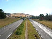
After bypassing Pietermaritzburg on the east and north, the N3 heads up a steep incline known as Town Hill before passing near Hilton and Howick; a road to the Southern Drakensberg (the R617) leaves the N3 at Howick. The route then becomes rather pictureque as it heads through the KwaZulu-Natal Midlands, passing through Mooi River (where another toll is located) before heading to Estcourt. Just past Estcourt, access to the Central and Northern Drakensberg via the R74 is provided, before the N3 heads in the direction of Ladysmith. The N3 passes Ladysmith to the west, with the N11 providing access to Ladysmith itself. The N3 from Cedara to Heidelberg is managed by a private concessionaire, the N3 Toll Concession.[2]
A few kilometres after the N11 interchange, the N3 is tolled once again; the dual-carriageway freeway also ending at this point. From here, the N3 ascends the South African plateau via Van Reenen's Pass; at the top of the pass, the N3 crosses into the Free State.
Free State
After crossing into the Free State, the N3 heads to Harrismith, where the N5 leaves it (providing a route to Bloemfontein and Cape Town via the N1). The N3 then heads to the north, and passes the town of Warden and heads towards Villiers, where a toll is located. Immediately after Villers, the N3 crosses the Vaal River and enters Mpumalanga.
Mpumalanga
The N3 then heads through the south-western tip of Mpumalanga in the direction of Heidelberg. Just before reaching Heidelberg, the N3 is tolled; this also marks the point where the N3 crosses into Gauteng. The N3 then bypasses Heidelberg before heading towards Johannesburg.
Gauteng
On approaching Johannesburg, the N3 passes the townships of Katlehong and Vosloorus (Where it meets the R21) before reaching Alberton and intersecting the N17 . Almost immediately afterwards, the N12 (the Southern Bypass portion of the Johannesburg Ring Road) merges with the N3, with the N3 then becoming the Eastern Bypass portion of the Johannesburg Ring Road. The N3 heads through Germiston (where the M2 provides access to the Johannesburg Central Business District) before heading to Bedfordview, where the N12 leaves the N3 at the Gilooly's Interchange and provides access to the East Rand. From here, the N3 passes Edenvale and Alexandra before terminating at the Buccleuch Interchange just south of Midrand and north of Sandton, which is the point at which the N3, N1 and M1 converge.
Alternative route
Where the N3 has been realigned, the old alignment has been designated R103. The R103 exists in three sections: between Durban and Ladysmith, between Warden and Villiers, and between Heidelberg and Johannesburg. The only exception is within Durban itself, where most of the old N3 alignment is designated as the M13 instead of having the usual R103 designation; the R103 diverges from the M13 in the suburb of Winston Park.
The R103 is typically used to avoid the toll plazas on the N3, with one notable exception being the Tugela East Toll Plaza located on the R103 itself where the R103 and N3 meet north of Ladysmith.
Prior to the redesignation of the National Route numbers in 1971, the N3 moved east at Heidelberg and passed through the towns of Standerton, Volksrust and Newcastle via Laign's Neck Pass, before joining the present alignment at Ladysmith. This route now designated R23 between Heidelberg and Volksrust and N11 thereafter remains an alternative to the N3.
Dual carriageway sections
Following the opening of the motorway section in December 2001 between Heidelberg and Villiers, the N3 now has at least two lanes in each direction for its entire length between the two cities. The section between Johannesburg and Villiers is dual carriageway motorway. Between Villiers and Warden the road is single carriageway motorway with two lanes in each direction. From Warden to Keeversfontein (Tugela Toll Plaza) the road is no longer motorway but retains two lanes in each direction. Thereafter, the route to Durban is dual carriageway motorway. This last section is the second longest motorway by route number, but the longest motorway following one alignment in South Africa.
Proposed Future realignment
There are certain individuals proposing plans to re-route one section of the N3 between Keeversfontein (Tugela Toll Plaza) near Ladysmith, and the start of the tolled section near Warden, probably meeting the present alignment just south of Warden. This would involve the diversion of the road over De Beer's Pass, as opposed to Van Reenen's Pass. Not only would it reduce the route distance by 14 kilometres, but would have a lower gradient. Proponents of the new road argue that the existing Van Reenen's Pass is too steep for heavy trucks and exceeds the maximum gradient of 1:7 for an officially declared national road. This has caused a huge outcry among residents of Harrismith and Van Reenen, who rely on passing traffic to sustain businesses such as restaurants, petrol stations, and holiday rest places.
The N3 Toll Concession has stated that the De Beer's bypass will be required when daily traffic volumes reach 13,900 vehicles - the current traffic volume at Van Reenen is 11,000 vehicles, and based on projected increases in traffic volumes, the bypass will need to be operational by the end of 2014, with construction commencing in the second half of 2011. However, they carefully fail to mention the additional cost this will entail for the general public and road users, which would be paid at the additional toll plaza to be added as part of the new route. Furthermore, the additional impact on congestion this new toll plaza will have on the traffic may in fact be worse than the congestion caused by the steep gradient of the current route.[3]
Tolls
Most of the road is only usable upon the payment of toll. There are toll plazas at Marianhill, Mooiriver, Tugela, Villiers and Heidelberg. As mentioned above, most of the toll plazas can be avoided by using the R103.[4]
A sixth toll plaza is likely to be constructed south of Warden when the De Beer's bypass (mentioned above) is built.[3]
Open road tolling of the northernmost part of the N3, from Black Reef Road (Old Barn Interchange) to Buccleuch Interchange, came into effect from December 2013. There are a number of electronic toll gantries located on this stretch, which charge road users according to their estimated distances travelled.
Notable interchanges
50 50 [Cato Ridge] Southbound / Northbound 55 55 [Camperdown] Southbound / Northbound 60 60 [Umlaas Road] Southbound / Northbound 65 65 [Lynnefield Park / Lion Park] Southbound / Northbound
| Distance from origin (km) | Exit number | Destinations | Notes |
|---|---|---|---|
| 0 | Durban Central Business District | N3 begins | |
| 8 | 165 | N2 - Stanger, Port Shepstone | |
| 17 | 17 | M13 - Pinetown | Northbound only |
| 20 | 20 | M7 - Pinetown, Queensburgh | Southbound only |
| 27 | Mariannhill Toll Plaza | ||
| 35 | 35 | M13 - Hillcrest | Southbound only |
| 76 | 76 | Pietermaritzburg | Northbound only |
| 77 | 77 | R56 - New England Road | |
| 81 | 81 | R33 - Greytown | |
| 83 | 83 | Pietermaritzburg | Southbound only |
| 99 | 99 | R617 - Bulwer, Southern Drakensberg | |
| 143 | 143 | Mooi River | Mooi Toll Plaza |
| 179 | 179 | Central Drakensberg | |
| 194 | 194 | R74 - Colenso, Winterton, Northern Drakensberg | |
| 230 | 230 | N11 - Ladysmith R616 - Bergville | |
| 246 | 246 | R103 - Ladysmith | Tugela Toll Plaza (on N3) Tugela East Toll Plaza (on R103) Dual-carriageway ends Proposed start of De Beer's bypass |
| 272 | KwaZulu-Natal/Free State provincial border | ||
| 301 | 29 | N5 - Harrismith, Bethlehem, Bloemfontein (via N1) | |
| 354 | 82 | Warden | Proposed end of De Beer's bypass |
| 405 | 133 | R34 - Vrede, Frankfort | |
| 441 | 169 | R26 - Villiers | Wilge Toll Plaza |
| 442 | Free State/Mpumalanga provincial border Dual-carriageway recommences | ||
| 447 | 5 | R51 - Balfour R54 - Vereeniging | |
| 490 (approx.) | Mpumalanga/Gauteng provincial border De Hoek Toll Plaza | ||
| 501 | 59 | R23 - Heidelberg (south), Standerton | |
| 508 | 66 | R42 - Heidelberg (central), Nigel | |
| 512 | 70 | R23 - Heidelberg (north), Benoni | |
| 545 | 103 | N17 - Johannesburg, Springs | Gosforth Toll Plaza |
| 547 | 105 | N12 - Potchefstroom, Kimberley | N12 merges with N3 |
| 550 | 108 | M2 - Johannesburg, Germiston | |
| 555 | 113 | N12 - Witbank R24 - Johannesburg, OR Tambo International Airport | N12 separates from N3 and merges with R24 |
| 569 | 104 | M1 - Johannesburg | N3 ends |
Notes
- ↑ Falkner, John (May 2012). South African Numbered Route Description and Destination Analysis (Report). National Department of Transport. pp. 13–15. Archived from the original on 6 June 2014. Retrieved 12 August 2014.
- ↑
- 1 2 "N3 route to be shortened". Retrieved 2008-09-10.
- ↑ "N3 Toll Road Sections". Archived from the original on 2006-09-24.
Coordinates: 28°18′56″S 29°11′56″E / 28.315678°S 29.198914°E