KwaDukuza
| KwaDukuza Stanger | |
|---|---|
 KwaDukuza  KwaDukuza KwaDukuza (South Africa)  KwaDukuza KwaDukuza (Africa) | |
| Coordinates: 29°20′00″S 31°17′30″E / 29.33333°S 31.29167°ECoordinates: 29°20′00″S 31°17′30″E / 29.33333°S 31.29167°E | |
| Country | South Africa |
| Province | KwaZulu-Natal |
| District | iLembe |
| Municipality | KwaDukuza |
| Established | 1825 as Dukuza, 1873 as Stanger [1] |
| Area[2] | |
| • Total | 32.37 km2 (12.50 sq mi) |
| Population (2011)[2] | |
| • Total | 51,536 |
| • Density | 1,600/km2 (4,100/sq mi) |
| Racial makeup (2011)[2] | |
| • Black African | 53.0% |
| • Coloured | 1.9% |
| • Indian/Asian | 43.7% |
| • White | 0.7% |
| • Other | 0.7% |
| First languages (2011)[2] | |
| • English | 47.7% |
| • Zulu | 46.0% |
| • Xhosa | 1.4% |
| • Other | 4.8% |
| Time zone | UTC+2 (SAST) |
| Postal code (street) | 4449 |
| PO box | 4450 |
KwaDukuza (also known as Stanger) is a town in KwaZulu-Natal, South Africa. In 2006, its official name was changed from Stanger to KwaDukuza, but the Zulu people in the area called it "Dukuza" well before then, and many white South Africans still use the name "Stanger" (see below) "Stanger" has also been used on new road signs in the area.[3][4][5]
The town has been under major economical construction since 2015, and currently has a multimillion-rand regional shopping mall being built, which will be the first of its kind in the town and the first major construction site on the North Coast since the completion of the Ballito Junction regional mall.[6][7]
In February 2018, the town opened the KwaDukuza Private Hospital, the second major hospital in the area.
In March 2018, KwaDukuza mayor, Ricardo Mthembu announced that KwaDukuza attended the 9th World Urban Forum in Malaysia and agreed to an agenda for the town to Go Green by 2030. Mthembu also stated, "KwaDukuza is one of the few South African municipalities to have signed the Compact of Mayors and we continue to report globally on our efforts on promoting climate change and energy efficiency. This approach fulfils our vision of being a competitive and global player as we progress towards becoming a sustainable city by 2030".[8]
Name
The town was named to honour William Stanger, a surveyor-general in South Africa. In 2006, the Minister of Arts and Culture approved a name change from Stanger to KwaDukuza, which was published in the Government Gazette of South Africa on 3 March 2006.
History
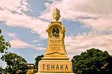
The town was founded about 1820 by King Shaka and was named KwaDukuza (Zulu: Place of the Lost Person) because of the capital's labyrinth of huts. After Shaka was assassinated on 22 September 1828 during a coup by two of his half-brothers, Dingane and Umthlangana (Mhlangane), the town was burnt to the ground. In 1873, European settlers built a town on the site, naming it Stanger after William Stanger, the surveyor-general of Natal.
Stanger became a municipality in 1949 and is the commercial, magisterial and railway centre of an important sugar-producing district. A small museum adjoins the site of Shaka's grave, a grain pit in the town centre. The town and its vibrant inhabitants are surrounded by sugar cane fields, bush and the mahogany tree where Shaka held meetings, which still stands in front of the municipal offices. The Shaka Day festival, a colorful ceremony of 10,000 or more Zulu, is held at the KwaDukuza Recreation Grounds on 24 September every year. The festival is usually attended by dignitaries to mark the significance of the Zulu nation.
The Stanger North Coast Museum houses historical items and information on Shaka, the sugar industry and local history. The town has an eastern flavour because of the influx of labourers from India in the late 19th and the early 20th centuries for sugarcane barons, such as Liege Hulett. The first few hundred Indian families left Port Natal for the cane farms on 17 November 1860. The importing of Indian laborers was stopped in 1911, when their numbers exceeded 100,000. Most Indians did not return when their work contracts expired but exchanged their return-trip passes for money or property. The growth of the Indian community changed the economic and cultural nature of the town. Ccelebratyions include Diwali and the Winter Fair, the latter being a fundraiser for child welfare.
Climate
The Köppen-Geiger climate classification system classifies the KwaDuzuka climate as humid subtropical (Cfa),[9] with more rain in the summer.
The highest record temperature was 43 °C (109 °F) on February 3, 2008, and the lowest record temperature was 5 °C (41 °F) on June 12, 2013.[10]
| Climate data for KwaDukuza | |||||||||||||
|---|---|---|---|---|---|---|---|---|---|---|---|---|---|
| Month | Jan | Feb | Mar | Apr | May | Jun | Jul | Aug | Sep | Oct | Nov | Dec | Year |
| Record high °C (°F) | 40 (104) |
43 (109) |
41 (106) |
38 (100) |
39 (102) |
37 (99) |
35 (95) |
39 (102) |
43 (109) |
41 (106) |
41 (106) |
41 (106) |
43 (109) |
| Average high °C (°F) | 28.4 (83.1) |
28.7 (83.7) |
28.3 (82.9) |
26.5 (79.7) |
24.8 (76.6) |
23.2 (73.8) |
22.8 (73) |
23.8 (74.8) |
24.6 (76.3) |
25.2 (77.4) |
26.2 (79.2) |
27.8 (82) |
25.9 (78.5) |
| Daily mean °C (°F) | 24.2 (75.6) |
24.5 (76.1) |
23.9 (75) |
21.8 (71.2) |
19.4 (66.9) |
17.3 (63.1) |
16.9 (62.4) |
18.2 (64.8) |
19.6 (67.3) |
20.8 (69.4) |
21.9 (71.4) |
23.5 (74.3) |
21 (69.8) |
| Average low °C (°F) | 20.1 (68.2) |
20.4 (68.7) |
19.5 (67.1) |
17.1 (62.8) |
14.1 (57.4) |
11.5 (52.7) |
11.1 (52) |
12.6 (54.7) |
14.6 (58.3) |
16.4 (61.5) |
17.7 (63.9) |
19.3 (66.7) |
16.2 (61.2) |
| Record low °C (°F) | 16 (61) |
15 (59) |
15 (59) |
11 (52) |
6 (43) |
5 (41) |
6 (43) |
6 (43) |
5 (41) |
10 (50) |
7 (45) |
14 (57) |
5 (41) |
| Average precipitation mm (inches) | 118 (4.65) |
120 (4.72) |
125 (4.92) |
72 (2.83) |
60 (2.36) |
37 (1.46) |
33 (1.3) |
41 (1.61) |
60 (2.36) |
92 (3.62) |
114 (4.49) |
119 (4.69) |
991 (39.01) |
| Source #1: Climate-Data.org (altitude: 60m)[9] | |||||||||||||
| Source #2: Voodoo Skies for record temperatures[10] | |||||||||||||
Schools
- Stanger Manor Secondary School
- Stanger Secondary School
- Glenhills Secondary School
- Glenhills Primary School
- Stanger M.L. Sultan Secondary School
- Stanger High School
- Dawnview Primary School
- Zakkariyya Muslim School
- Stanger Primary School
- Stanger Manor Primary School
- Stanger South Secondary School]]
- Tshelenkosi secondary school
Notable residents
See also
References
- ↑ "KwaDUKUZA / STANGER – A History". sahistory.org. Retrieved 2009-08-31.
- 1 2 3 4 "Main Place KwaDukuza". Census 2011.
- ↑ Watson Highway, La Mercy, South Africa (Map). Google Maps. Retrieved 2010-12-12.
- ↑ R 102, Nkwazi, South Africa (Map). Google Maps. Retrieved 2010-12-12.
- ↑ N2, South Africa (Map). Google Maps. Retrieved 2010-12-12.
- ↑ https://www.ballitojunction.co.za/about-us
- ↑ https://northcoastcourier.co.za/85095/construction-underway-new-stanger-mall/
- ↑ https://northcoastcourier.co.za/103184/going-green-by-2030/
- 1 2 "Climate: KwaDukuza - Climate graph, Temperature graph, Climate table". Climate-Data.org. Retrieved 2014-01-17.
- 1 2 "Stanger, South Africa". Voodoo Skies. Retrieved 2014-01-17.
Municipalities and communities of ILembe District Municipality, KwaZulu-Natal | ||
|---|---|---|
District seat: KwaDukuza (Stanger) | ||
| Mandeni | .svg.png) | |
| KwaDukuza | ||
| Ndwedwe | ||
| Maphumulo | ||