Port Shepstone
| Port Shepstone | |
|---|---|
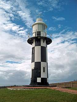 Port Shepstone Lighthouse | |
 Port Shepstone  Port Shepstone Port Shepstone (South Africa)  Port Shepstone Port Shepstone (Africa) | |
| Coordinates: 30°45′00″S 30°27′00″E / 30.75000°S 30.45000°ECoordinates: 30°45′00″S 30°27′00″E / 30.75000°S 30.45000°E | |
| Country | South Africa |
| Province | KwaZulu-Natal |
| District | Ugu |
| Municipality | Ray Nkonyeni Municipality |
| Established | 1867 |
| Area[1] | |
| • Total | 38.02 km2 (14.68 sq mi) |
| Population (2011)[1] | |
| • Total | 35,633 |
| • Density | 940/km2 (2,400/sq mi) |
| Racial makeup (2011)[1] | |
| • Black African | 39.7% |
| • Coloured | 6.3% |
| • Indian/Asian | 32.1% |
| • White | 21.3% |
| • Other | 0.5% |
| First languages (2011)[1] | |
| • English | 55.3% |
| • Zulu | 21.4% |
| • Xhosa | 10.5% |
| • Afrikaans | 9.3% |
| • Other | 3.5% |
| Time zone | UTC+2 (SAST) |
| Postal code (street) | 4240 |
| PO box | 4240 |
| Area code | 039 |
Port Shepstone is a town situated on the mouth of the largest river on the south coast of KwaZulu-Natal, South Africa, the Mzimkulu River (isiXhosa and isiZulu - 'large place').[2] It is located between Hibberdene and Margate and is located 120 km south of Durban. It is the administrative, educational and commercial centre for southern Natal.
History
Port Shepstone was founded in 1867 when marble was discovered nearby and is named after Sir Theophilus Shepstone of the Natal government of the 1880s. William Bazley built a harbour and the first coaster entered the harbour on the May 8, 1880. In 1882 a party of 246 Norwegian immigrants settled here and played a large part in the development of the area. After the opening of the railway to Durban in 1901 the harbour fell in disuse and eventually the river silted up again making it impossible to use. The 27,000 candela lighthouse still stands at the mouth of the Mzimkulu River.
Norwegian settlers
Norwegian immigration to Port Shepstone began in the late 19th century, when 246 Norwegians came ashore with a steamship which arrived in 1882. They founded a nearby interior village the same year, known as Marburg. The Norwegian settlers played a large role in the development of not only Marburg, but also Port Shepstone and nearby areas.[3][4] Norwegian immigration to the region was in part a result of the Natal Immigration Board’s efforts to claim land for Europeans in South Africa. When the Norwegians first arrived, they were the largest European group in Alfred County. Remains of the Norwegian presence can be seen in place names throughout Port Shepstone, e.g. Fredheim and Oslo Beach with its main street King Haakon Drive.[5]
The Norwegians erected a Norwegian Lutheran church, school, cultural hall, choir, and rowing club. A newspaper in Norwegian language was also distributed in Port Shepstone. Drinks such as akvavit and cuisine, including cheese from soured milk, were easily accessible.[6] When the Norwegians arrived, few European settlers lived in the area and the town of Port Shepstone consisted of one hotel, two cabins, one shop, and little else.[7]
When the railroad arrived in Port Shepstone in 1901, the travel time to Durban was reduced to five hours, and the city became far less isolated. The railway connection opened for increased immigration for other settlers, and the Norwegians were soon outnumbered by German- and British settlers. Between 1911-12, the number of students at the Norwegian school became too low for the school to keep open, and it consequentially closed.[8]
Industries and agriculture
Its industries include a sugar mill, a lime works and a marble quarry. Timber, wattle bark and sub-tropical fruit are produced in the district.
Transport
Port Shepstone railway station opened in 1917, serving as both the southern terminus of the Cape gauge line from & to Durban, as well as the southern coastal terminus of the narrow gauge Alfred County Railway to Harding.
After the standard gauge Transnet passenger services shut down in 1986, the ACR continued operations until 2005, when the famous Banana Express ceased operation.[9]
Port Shepstone is connected by the N2, R61, R102, R620.
Education
The first school was opened in 1883 but by 1950 the school became too small. The Port Shepstone School split into two, the Port Shepstone Primary School and the Port Shepstone High School. There is also the Port Shepstone Secondary School. There are other schools in the surrounding areas such as Mlonde High School, Marburg Secondary School, Marburg Primary School, R.A Engar Primary School, Jai Jind Primary School, Margate Middle School and Margate Primary.
Twin towns – sister cities
Port Shepstone is twinned with:
- New York , USA[10]
Climate
| Climate data for Port Shepstone | |||||||||||||
|---|---|---|---|---|---|---|---|---|---|---|---|---|---|
| Month | Jan | Feb | Mar | Apr | May | Jun | Jul | Aug | Sep | Oct | Nov | Dec | Year |
| Average high °C (°F) | 26 (79) |
26 (79) |
25 (77) |
24 (75) |
23 (73) |
21 (70) |
21 (70) |
21 (70) |
21 (70) |
22 (72) |
23 (73) |
25 (77) |
23 (73) |
| Daily mean °C (°F) | 23 (73) |
23 (73) |
23 (73) |
21 (70) |
19 (66) |
17 (63) |
16 (61) |
17 (63) |
18 (64) |
19 (66) |
20 (68) |
22 (72) |
19 (66) |
| Average low °C (°F) | 20 (68) |
20 (68) |
20 (68) |
17 (63) |
15 (59) |
12 (54) |
12 (54) |
13 (55) |
15 (59) |
16 (61) |
18 (64) |
19 (66) |
16 (61) |
| Average precipitation mm (inches) | 121 (4.76) |
126 (4.96) |
148 (5.83) |
82 (3.23) |
60 (2.36) |
31 (1.22) |
38 (1.5) |
49 (1.93) |
87 (3.43) |
114 (4.49) |
123 (4.84) |
127 (5) |
1,106 (43.54) |
| Source: Weatherbase [11] | |||||||||||||
References
- 1 2 3 4 "Main Place Port Shepstone". Census 2011.
- ↑ http://route56.co.za/umzimkulu.html
- ↑ Raper, R.E. Dictionary of Southern African Place Names. Human Sciences Research Council (South Africa).
- ↑ Bond, John (1956). They were South Africans. OXFORD UNIVERSITY PRESS. p. 90.
- ↑ Odén, Bertil and Haroub Othman (1989). Regional Cooperation in Southern Africa: A Post-apartheid Perspective. Nordic Africa Institute. Pages 38-39. ISBN 9789171062987.
- ↑ Kjerland, Kirsten Alsaker (2014). Navigating Colonial Orders: Norwegian Entrepreneurship in Africa and Oceania. Berghahn Books. Page XV. ISBN 9781782385400.
- ↑ Lund, Fredrik Larsen (2017). Norske utposter. Vega forlag. Page 345. ISBN 978-82-8211-537-7.
- ↑ Lund, Fredrik Larsen (2017). Norske utposter. Vega forlag. Pages 390-391. ISBN 978-82-8211-537-7.
- ↑ "KNOCKING LINES OFF THE MAP". railwaysafrica.com. 2009-02-27. Retrieved 2009-07-10.
- ↑ Lindquist, Ted. "Internationella frågor och vänorter". Oskarshamn Municipality (in Swedish). Archived from the original on 2013-08-12. Retrieved 2013-07-25.
- ↑ "Climate Statistics for Port Shepstone, Kwazulu-Natal, South Africa". Retrieved May 8, 2012.
Municipalities and communities of Ugu District Municipality, KwaZulu-Natal | ||
|---|---|---|
District seat: Port Shepstone | ||
| Ray Nkonyeni | .svg.png) | |
| Umzumbe | ||
| uMuziwabantu | ||
| Vulamehlo | ||
| uMdoni | ||