Mpumalanga
| Mpumalanga iMpumalanga (in Swazi and Zulu) IMpumalanga (in Southern Ndebele) | |||
|---|---|---|---|
| Province of South Africa | |||
| |||
| Motto(s): Omnia labor vincit (Labour will conquer all) | |||
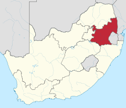 Location of Mpumalanga in South Africa | |||
| Country | South Africa | ||
| Established | 27 April 1994 | ||
| Capital | Mbombela (Nelspruit) | ||
| Districts | |||
| Government | |||
| • Type | Parliamentary system | ||
| • Premier | Refilwe Mtshweni (ANC) | ||
| • Legislature | Mpumalanga Provincial Legislature | ||
| Area[1]:9 | |||
| • Total | 76,495 km2 (29,535 sq mi) | ||
| Area rank | 8th in South Africa | ||
| Highest elevation | 2,331 m (7,648 ft) | ||
| Population (2011)[1]:18[2] | |||
| • Total | 4,039,939 | ||
| • Estimate (2018) | 4,523,900 | ||
| • Rank | 6th in South Africa | ||
| • Density | 53/km2 (140/sq mi) | ||
| • Density rank | 3rd in South Africa | ||
| Population groups[1]:21 | |||
| • Black African | 90.7% | ||
| • White | 7.5% | ||
| • Coloured | 0.9% | ||
| • Indian or Asian | 0.7% | ||
| Languages[1]:25 | |||
| • Swazi | 27.7% | ||
| • Zulu | 24.1% | ||
| • Tsonga | 10.4% | ||
| • Southern Ndebele | 10.1% | ||
| • Northern Sotho | 9.3% | ||
| • Afrikaans | 7.2% | ||
| • Southern Sotho | 3.5% | ||
| • English | 3.1% | ||
| Time zone | UTC+2 (SAST) | ||
| ISO 3166 code | ZA-MP | ||
| Website | www.mpumalanga.gov.za | ||
Mpumalanga (/əmˌpuːməˈlɑːŋɡə/ (![]()
Geography
Before 1994, it was part of the now-defunct Transvaal Province. The province's name was Eastern Transvaal, from its initial establishment in 1994 until 24 August 1995. Prior to the establishment of the province, the term "Eastern Transvaal" was used to refer to the eastern part of Transvaal Province.
The Drakensberg escarpment divides Mpumalanga into a westerly half consisting mainly of high-altitude grassland called the Highveld and an eastern half situated in low-altitude subtropical Lowveld/Bushveld, mostly savanna habitat. The southern half of the Kruger National Park is in the latter region. The Drakensberg exceeds heights of 2000 m in most places, with this central region of Mpumalanga being very mountainous. These regions have alpine grasslands and small pockets of Afromontane forest. The Lowveld is relatively flat with interspersed rocky outcrops. The Lebombo Mountains form a low range in the far east, on the border with Mozambique.
Some of the oldest rocks on earth have been found in the Barberton area; these ancient greenstones and metamorphosed granites form the Crocodile River Mountains in the southeast of the province. The Lowveld is underlaid by African Cratonic Basement rocks of ages in excess of 2 billion years. The Highveld is mostly Karoo Sequence sedimentary rock of a younger, Carboniferous to Permian age.
Mpumalanga is the only South African province to border two provinces of Mozambique (Gaza Province to the northeast and Maputo Province to the east), as well as all four districts of Swaziland (Lubombo, Hhohho, Manzini, and Shiselweni Districts).
Climate
The Lowveld is subtropical, due to its latitude and proximity to the warm Indian Ocean. The Highveld is comparatively much cooler, due to its altitude of 2300 m to 1700 m above sea level. The Drakensberg escarpment receives the most precipitation, with all other areas being moderately well-watered by mostly summer thunderstorms. The Highveld often experiences severe frost, while the Lowveld is mostly frost-free. Winter rainfall is rare, except for some drizzle on the escarpment. The differences in climate are demonstrated below by the capital, Nelspruit, which is in the Lowveld, an hour from Belfast on the Highveld.
- Nelspruit averages: January maximum: 29 °C (min: 19 °C), July maximum: 23 °C (min: 6 °C), annual precipitation: 767 mm
- Belfast averages: January maximum: 23 °C (min: 12 °C), June maximum: 15 °C (min: 1 °C), annual precipitation: 878 mm
Fauna and flora
The diverse and special flora and fauna of the province enjoys protection in a range of nature reserves, including:
- Blyderivierspoort Nature Reserve
- Great Limpopo Transfrontier Park, previously known as Gaza-Kruger-Gonarezhou Transfrontier Park. This international game park brings together some of the best and most established wildlife areas in southern Africa. The park is managed as an integrated unit across an unprecedented three international boundaries which includes the Kruger National Park (South Africa), Limpopo National Park (Mozambique) and Gonarezhou National Park (Zimbabwe).
- Sabi Sand Game Reserve, which is built up of numerous private reserves: Nottens Bush Camp,[4] Idube Safari Lodge, Chitwa Chitwa Game Lodge, Djuma Game Reserve, Exeter Game Lodge, Inyati Private Game Reserve, Leopard Hills Private Game Reserve, Lion Sands Private Game Reserve, Londolozi Game Reserve, Mala Mala Game Reserve, Savanna Private Game Reserve and Ulusaba Game Lodge.
Law and government
The Mpumalanga Province's legislation is an amalgam of national and regional legislation promulgated before the establishment of the province on 27 April 1994 and legislation which it has itself promulgated since it came into existence. Lists of and the original texts of this legislation are available through South African governmental websites. Amended and updated versions of the legislation is available through commercial vendors on subscription and at a price. See External links for more information.
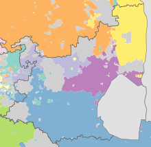
Municipalities
.svg.png)
Mpumalanga Province is divided into three district municipalities. The district municipalities are in turn divided into 18 local municipalities:
District municipalities
Economy
Farming
The climatic contrasts between the drier Highveld region, with its cold winters, and the hot, humid Lowveld allow for a variety of agricultural activities. 68% of Mpumalanga is used by agriculture. Crops include maize, wheat, sorghum, barley, sunflower seed, soybeans, macadamia's, groundnuts, sugar cane, vegetables, coffee, tea, cotton, tobacco, citrus, subtropical and deciduous fruit. The Mango c.v Mpumalanga is famous among mango lovers but hardly known commercially.
Forestry is extensive around Sabie in the far north east of the province. Located near the forests, Ngodwana is the site of one of South Africa's largest paper mills (Sappi).[5]
Natural grazing covers approximately 14% of Mpumalanga. The main products are beef, mutton, wool, poultry and dairy.
Mining
Extensive mining is done and the minerals found include gold, platinum group metals, silica, chromite, vanadiferous magnetite, argentiferous zinc, antimony, cobalt, copper, iron, manganese, tin, coal, andalusite, chrysotile asbestos, kieselguhr, limestone, magnesite, talc and shale.
Gold was first discovered in Mpumalanga province in 1883 by Auguste Roberts in the mountains surrounding what is now Barberton. Gold is still mined in the Barberton area today.[6]
Mpumalanga accounts for 83% of South Africa's coal production. 90% of South Africa's coal consumption is used for electricity generation and the synthetic fuel industry. Coal power stations are in proximity to the coal deposits. A coal liquefaction plant in Secunda (Secunda CTL) is one of the country's two petroleum-from-coal extraction plants, which is operated by the synthetic fuel company Sasol.[7]
Attractions
Mpumalanga is popular with tourists. Kruger National Park, established in 1898 for the protection of Lowveld wildlife, covering 20,000 square kilometres (7,700 sq mi), is a popular destination.[8] The other major tourist attractions include the Sudwala Caves and the Blyde River Canyon.
Many activities including the big jump, mountain and quad biking, horse trails, river rafting and big game viewing are endemic to the region. This is "Big Five" territory. Towns in the Lowveld are Barberton, Mbombela, White River, Sabie, Graskop, Hazyview, Malelane, Pilgrim's Rest, Lydenburg and Nkomazi.[9]
In 2008, a Haute Cuisine route was formed, trickling from Nelspruit down to Hazyview. The Lowveld Gourmet Route covers the four top fine dining restaurants the area has to offer. The restaurants include Summerfields Kitchen, Oliver’s Restaurant, Orange and Salt.[10]
The Wakkerstroom area in the Southern Mpumalanga highlands is a world-renowned birding hot spot. The special birds that tourists travel to see are Rudd's lark, Botha's lark, wattled crane and yellow-breasted pipit, among over 300 grassland species.
Demographics
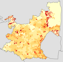
|
<1 /km²
1–3 /km²
3–10 /km²
10–30 /km²
30–100 /km² |
100–300 /km²
300–1000 /km²
1000–3000 /km²
>3000 /km² |
Some 30% of the people speak siSwati, the language of neighbouring Swaziland, with 26% speaking isiZulu, 10.3% isiNdebele, 10.2% Northern Sotho and 11.6% Xitsonga.
| Wikivoyage has a travel guide for Mpumalanga. |
| Wikimedia Commons has media related to Mpumalanga. |
See also
References
- 1 2 3 4 Census 2011: Census in brief (PDF). Pretoria: Statistics South Africa. 2012. ISBN 9780621413885. Archived (PDF) from the original on 13 May 2015.
- ↑ "Mid-year population estimates, 2018" (PDF). Statistics South Africa. 31 July 2018. Retrieved 29 July 2018.
- ↑ https://www.bbc.com/news/world-africa-42633571
- ↑ "Private Safari Lodge". nottens.co.za.
- ↑ Mpumalanga in brief: The economy of the province Archived 13 May 2006 at the Wayback Machine. (URL accessed 30 April 2006)
- ↑ "Barberton", Mpumalanga South Africa, ExploreSouthAfrica.net. (URL accessed 30 April 2006)
- ↑ "Coal", South Africa Country Analysis Brief, Energy Information Administration. (URL accessed 30 April 2006)
- ↑ "Kruger National Park", South Africa Explored.
- ↑ "Mpumalanga news". mpumalanga.co.za. Archived from the original on 1998-01-26.
- ↑ Mpumalanga Haute Cuisine
Links
| |||||||
| Provinces | |||||||
| Municipalities |
| ||||||
| Settlements |
| ||||||