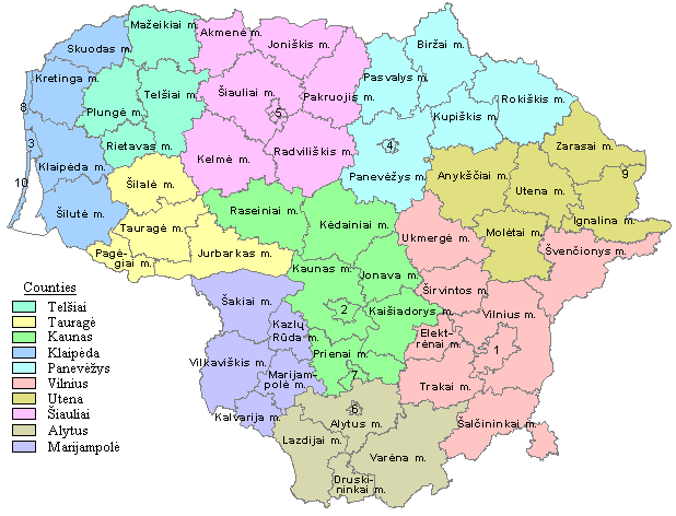
Municipalities of Lithuania
 |
|---|
| This article is part of a series on the politics and government of Lithuania |
| Constitution |
|
Legislature |
|
Judiciary |
|
Lithuania is divided into three layers of administrative divisions. The first-level division consists of 10 counties (Lithuanian: singular – apskritis, plural – apskritys). These are sub-divided into 60 municipalities (Lithuanian: plural – savivaldybės, singular – savivaldybė), which in turn are further sub-divided into over 500 smaller groups, known as elderships (Lithuanian: plural – seniūnijos, singular – seniūnija).
At the end of its tenure as a Soviet Socialist Republic, Lithuania's administrative divisions consisted of 44 regions, 12 cities, 80 towns, 19 settlements, and 426 rural districts.[1] The reform of this system was an immediate concern for the new government.[2] The Constitution of Lithuania, ratified in 1992, delegated the power of establishing future administrative units to the Lithuanian Parliament (Seimas). Accordingly, the Seimas passed two fundamental laws: a 1993 law on government representation and a 1994 law specifying the territorial-administrative units and their boundaries.[2] The current system of a set of municipalities under 10 counties was codified by 1995.[2] Several changes were made in 2000, resulting in 60 municipalities.[3] Ordinary municipal councilors are elected every four years from electoral lists using proportional representation. The mayor, who is a member of the council, is elected directly by the residents in a majority vote.[4] Before 2015, the mayors were elected by the municipal councils.
The largest municipality by population in Lithuania is Vilnius City Municipality with 542,626 residents, home to one fifth (18.6%) of the country's population. The smallest municipality by population is Neringa Municipality with 2,879 residents. The largest municipality by land area is Varėna District Municipality, which spans 2,216 km2 (856 sq mi), while the smallest is Alytus City Municipality at 40 km2 (15 sq mi).
Municipalities
| Municipality | County | Administrative center[5] | Area[6] | Pop. (2015)[6] | Density (2015)[6] |
|---|---|---|---|---|---|
| Šiauliai | Naujoji Akmenė | 844 km2 (208,556.94 acres; 325.87 sq mi) | 21,332 | 25.3 | |
| Alytus | Alytus | 40 km2 (9,884.22 acres; 15.44 sq mi) | 55,614 | 1,390.4 | |
| Alytus | Alytus[nb 1] | 1,403 km2 (346,688.85 acres; 541.70 sq mi) | 27,126 | 19.3 | |
| Utena | Anykščiai | 1,764 km2 (435,893.89 acres; 681.08 sq mi) | 26,393 | 15.0 | |
| Kaunas | Birštonas | 122 km2 (30,146.86 acres; 47.10 sq mi) | 4,371 | 35.8 | |
| Panevėžys | Biržai | 1,476 km2 (364,727.54 acres; 569.89 sq mi) | 25,937 | 17.6 | |
| Alytus | Druskininkai | 453 km2 (111,938.74 acres; 174.90 sq mi) | 20,728 | 45.8 | |
| Vilnius | Elektrėnai | 509 km2 (125,776.64 acres; 196.53 sq mi) | 24,164 | 47.5 | |
| Utena | Ignalina | 1,441 km2 (356,078.85 acres; 556.37 sq mi) | 16,806 | 11.7 | |
| Kaunas | Jonava | 943 km2 (233,020.37 acres; 364.09 sq mi) | 43,875 | 46.5 | |
| Šiauliai | Joniškis | 1,151 km2 (284,418.29 acres; 444.40 sq mi) | 23,807 | 20.7 | |
| Tauragė | Jurbarkas | 1,506 km2 (372,140.70 acres; 581.47 sq mi) | 28,162 | 18.7 | |
| Kaunas | Kaišiadorys | 1,087 km2 (268,603.55 acres; 419.69 sq mi) | 31,915 | 29.4 | |
| Marijampolė | Kalvarija | 440 km2 (108,726.37 acres; 169.88 sq mi) | 11,486 | 26.1 | |
| Kaunas | Kaunas | 157 km2 (38,795.54 acres; 60.62 sq mi) | 301,357 | 1919.5 | |
| Kaunas | Kaunas[nb 1] | 1,495 km2 (369,422.55 acres; 577.22 sq mi) | 88,396 | 59.1 | |
| Marijampolė | Kazlų Rūda | 555 km2 (137,143.49 acres; 214.29 sq mi) | 12,494 | 22.5 | |
| Kaunas | Kėdainiai | 1,677 km2 (414,395.72 acres; 647.49 sq mi) | 49,939 | 29.8 | |
| Šiauliai | Kelmė | 1,705 km2 (421,314.68 acres; 658.30 sq mi) | 29,559 | 17.3 | |
| Klaipėda | Klaipėda | 99 km2 (24,463.43 acres; 38.22 sq mi) | 156,141 | 1,577.2 | |
| Klaipėda | Gargždai | 1,340 km2 (331,121.21 acres; 517.38 sq mi) | 52,831 | 39.4 | |
| Klaipėda | Kretinga | 989 km2 (244,387.22 acres; 381.86 sq mi) | 39,758 | 40.2 | |
| Panevėžys | Kupiškis | 1,080 km2 (266,873.81 acres; 416.99 sq mi) | 18,678 | 17.3 | |
| Alytus | Lazdijai | 1,306 km2 (322,719.63 acres; 504.25 sq mi) | 20,813 | 15.9 | |
| Marijampolė | Marijampolė | 755 km2 (186,564.56 acres; 291.51 sq mi) | 58,027 | 76.9 | |
| Telšiai | Mažeikiai | 1,219 km2 (301,221.46 acres; 470.66 sq mi) | 55,441 | 45.5 | |
| Utena | Molėtai | 1,367 km2 (337,793.06 acres; 527.80 sq mi) | 19,233 | 14.1 | |
| Klaipėda | Nida | 90 km2 (22,239.48 acres; 34.75 sq mi) | 2,879 | 32.0 | |
| Tauragė | Pagėgiai | 536 km2 (132,448.48 acres; 206.95 sq mi) | 8,711 | 16.3 | |
| Šiauliai | Pakruojis | 1,315 km2 (324,943.58 acres; 507.72 sq mi) | 21,555 | 16.4 | |
| Klaipėda | Palanga | 79 km2 (19,521.33 acres; 30.50 sq mi) | 15,379 | 194.7 | |
| Panevėžys | Panevėžys | 50 km2 (12,355.27 acres; 19.31 sq mi) | 95,202 | 1,904.0 | |
| Panevėžys | Panevėžys[nb 1] | 2,177 km2 (537,948.42 acres; 840.54 sq mi) | 37,173 | 17.1 | |
| Panevėžys | Pasvalys | 1,289 km2 (318,518.84 acres; 497.69 sq mi) | 26,213 | 20.3 | |
| Telšiai | Plungė | 1,105 km2 (273,051.45 acres; 426.64 sq mi) | 36,052 | 32.6 | |
| Kaunas | Prienai | 1,032 km2 (255,012.75 acres; 398.46 sq mi) | 28,181 | 27.3 | |
| Šiauliai | Radviliškis | 1,634 km2 (403,770.19 acres; 630.89 sq mi) | 39,043 | 23.9 | |
| Kaunas | Raseiniai | 1,573 km2 (388,696.77 acres; 607.34 sq mi) | 35,013 | 22.3 | |
| Telšiai | Rietavas | 586 km2 (144,803.75 acres; 226.26 sq mi) | 8,096 | 13.8 | |
| Panevėžys | Rokiškis | 1,806 km2 (446,272.32 acres; 697.30 sq mi) | 32,191 | 17.8 | |
| Klaipėda | Skuodas | 911 km2 (225,113.00 acres; 351.74 sq mi) | 18,498 | 20.3 | |
| Marijampolė | Šakiai | 1,454 km2 (359,291.22 acres; 561.39 sq mi) | 30,321 | 20.9 | |
| Vilnius | Šalčininkai | 1,493 km2 (368,928.33 acres; 576.45 sq mi) | 32,705 | 21.9 | |
| Šiauliai | Šiauliai | 81 km2 (20,015.54 acres; 31.27 sq mi) | 104,569 | 1,291.0 | |
| Šiauliai | Šiauliai[nb 1] | 1,807 km2 (446,519.42 acres; 697.69 sq mi) | 41,767 | 23.1 | |
| Tauragė | Šilalė | 1,188 km2 (293,561.19 acres; 458.69 sq mi) | 24,869 | 20.9 | |
| Klaipėda | Šilutė | 1,714 km2 (423,538.62 acres; 661.78 sq mi) | 41,814 | 24.4 | |
| Vilnius | Širvintos | 906 km2 (223,877.48 acres; 349.81 sq mi) | 16,333 | 18.0 | |
| Vilnius | Švenčionys | 1,691 km2 (417,855.20 acres; 652.90 sq mi) | 25,719 | 15.2 | |
| Tauragė | Tauragė | 1,179 km2 (291,337.24 acres; 455.21 sq mi) | 41,341 | 35.1 | |
| Telšiai | Telšiai | 1,439 km2 (355,584.64 acres; 555.60 sq mi) | 43,922 | 30.5 | |
| Vilnius | Trakai | 1,207 km2 (298,256.20 acres; 466.03 sq mi) | 33,437 | 27.7 | |
| Vilnius | Ukmergė | 1,395 km2 (344,712.01 acres; 538.61 sq mi) | 36,919 | 26.5 | |
| Utena | Utena | 1,230 km2 (303,939.62 acres; 474.91 sq mi) | 40,454 | 32.9 | |
| Alytus | Varėna | 2,216 km2 (547,585.53 acres; 855.60 sq mi) | 23,528 | 10.6 | |
| Marijampolė | Vilkaviškis | 1,262 km2 (311,846.99 acres; 487.26 sq mi) | 39,465 | 31.3 | |
| Vilnius | Vilnius | 400 km2 (98,842.15 acres; 154.44 sq mi) | 542,626 | 1,356.6 | |
| Vilnius | Vilnius[nb 1] | 2,129 km2 (526,087.36 acres; 822.01 sq mi) | 95,620 | 44.9 | |
| Utena | Visaginas | 58 km2 (14,332.11 acres; 22.39 sq mi) | 20,249 | 349.1 | |
| Utena | Zarasai | 1,331 km2 (328,897.26 acres; 513.90 sq mi) | 17,035 | 12.8 |
See also
| Wikimedia Commons has media related to Category:Municipalities of Lithuania. |
- Administrative divisions of Lithuania
- Counties (Lithuanian: singular – apskritis, plural – apskritys)
- Elderships (or wards) (Lithuanian: plural – seniūnijos, singular – seniūnija).
- Seniūnaitija (sub-eldership)
- Cities (Lithuanian: plural – miestai, singular – miestas)
- Towns (Lithuanian: plural – miesteliai, singular – miestelis)
Notes and references
- Notes
- General
- "Law on the Territorial Administrative Units and Their Boundaries". Lietuvos Respublikos Seimas. 30 March 2010. Retrieved 28 September 2011.
- Specific
- ↑ Conference on Local and Regional Authority Co-operation in the Baltic Sea Area: proceedings, Kaunas, Lithuania, 21-23, April 1999. Council of Europe. January 2000. p. 9. ISBN 978-92-871-4538-3. Retrieved 16 February 2011.
- 1 2 3 Jolanta Vaičiūnienė (2008-11-14). "The Administrative–Territorial Reform in Lithuania: History and Today" (PDF). Council of Europe. Retrieved 16 February 2011.
- ↑ Local Economic and Employment Development (Program); Organisation for Economic Co-operation and Development (April 2007). Baltic partnerships: integration, growth and local governance in the Baltic Sea Region. OECD Publishing. p. 75. ISBN 978-92-64-02928-6. Retrieved 23 February 2011.
- ↑ "Law on elections to municipal councils". The Seimas of the Republic of Lithuania. Retrieved 31 July 2015.
- ↑ Municipality administrative centers and coats of arms are given by Statistics Lithuania in subpages under the Portrait of the Regions of Lithuania; e.g. Alytus town municipality Archived 2011-05-26 at the Wayback Machine..
- 1 2 3 "Area (land) at the beginning of the year, Population density at the beginning of the year, Resident population at the beginning of the year". Statistics Lithuania. Retrieved 4 February 2016.