Šilalė
| Šilalė | |||
|---|---|---|---|
| Town | |||
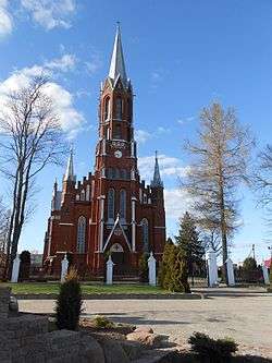 Church of St. Francis of Assisi in Šilalė | |||
| |||
.png) Šilalė Location in Šilalė district municipality Location of Šilalė district in Lithuania 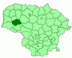 | |||
| Coordinates: 55°29′N 22°11′E / 55.483°N 22.183°ECoordinates: 55°29′N 22°11′E / 55.483°N 22.183°E | |||
| Country |
| ||
| Ethnographic region | Samogitia | ||
| County | Tauragė County | ||
| Municipality | Šilalė district municipality | ||
| Eldership | Šilalė city eldership | ||
| Capital of |
Šilalė district municipality Šilalė city eldership Šilalė rural eldership Traksėdžiai eldership | ||
| First mentioned | 1533 | ||
| Granted city rights | 1950 | ||
| Population (2011) | |||
| • Total | 5,492 | ||
| Time zone | UTC+2 (EET) | ||
| • Summer (DST) | UTC+3 (EEST) | ||

Šilalė (![]()
History
The town is part of the Samogitian ethnographic region of Lithuania and was first mentioned in the sixteenth century. Its name derives from the generic word sila ("Pinewood") and Samogitian suffix -alė.
In July 1941, 135 Jewish men from Šilalė were shot on a site in the Jewish cemetery.[1] In September 1941, the Jewish women and children of Šilalė were shot in the Tūbinės forest. Around 1,300 Jews were massacred by an Einsatzgruppen of Germans and local Lithuanian collaborators.[2]
Population
Ethnic composition
2011 - population of 5,492 people:
- Lithuanian - 99.02% (5438);
- Russian - 0.33% (18);
- Other - 0.66% (36).
2001 - population of 6,281 people:
- Lithuanian - 99.23% (6235);
- Russian - 0.37% (23);
- Other - 0.37% (23).
Notable people
- Stasys Girėnas (1893-1933), Lithuanian-American pilot
- Lukas Lekavičius, professional basketball player
References
| Wikimedia Commons has media related to Šilalė. |
| Municipalities |  | |
|---|---|---|
| Cities | ||
| Towns | ||
| Villages | ||