Ignalina District Municipality
| Ignalina District Municipality Ignalinos rajono savivaldybė | ||
|---|---|---|
| Municipality | ||
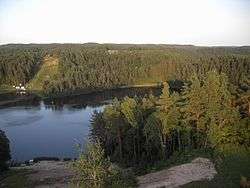 Žaliasis lake | ||
| ||
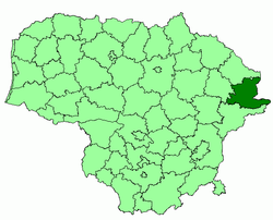 Location of Ignalina district municipality within Lithuania | ||
| Coordinates: 55°20′52″N 26°14′27″E / 55.34778°N 26.24083°ECoordinates: 55°20′52″N 26°14′27″E / 55.34778°N 26.24083°E | ||
| Country |
| |
| Ethnographic region | Aukštaitija | |
| County |
| |
| Capital | Ignalina | |
| Elderships | 12 | |
| Area | ||
| • Total | 1,447 km2 (559 sq mi) | |
| Area rank | 18-19th | |
| Population (2014 census) | ||
| • Total | 18,414 | |
| • Density | 13/km2 (33/sq mi) | |
| Time zone | UTC+2 (EET) | |
| • Summer (DST) | UTC+3 (EEST) | |
| Telephone code | 386 | |
| Major settlements |
| |
| Website |
www | |
.svg.png)
Ignalina District Municipality is one of 60 municipalities in Lithuania.[1]
Structure
District structure:
- 2 cities – Dūkštas and Ignalina;
- 3 towns – Mielagėnai, Rimšė and Tverečius;
- 726 villages.
- Ignalina District Municipality consists of 12 smaller administration units - elderships.
Population of largest Ignalina District Municipality elderships (2014-07-01):
- Ignalina town – 5605
- Didžiasalis – 1691
- Vidiškės – 1278
- Dūkštas – 1756
- Kazitiškis – 1039
- Naujasis Daugėliškis – 1491
- Mielagėnai – 887
- Ceikiniai – 533
- Linkmenys – 970
- Rimšė – 999
- Tverečius – 590
In total - 18414 inhabitants.
Nature and geography
 Lūšiai
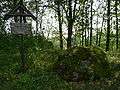 Rock of Pliateriai
_1.jpg) The Srovė river
The Srovė river
References
| Municipalities |  | |
|---|---|---|
| Cities | ||
| Towns | ||
| Villages | ||
This article is issued from
Wikipedia.
The text is licensed under Creative Commons - Attribution - Sharealike.
Additional terms may apply for the media files.