Zlatibor
| Zlatibor | |
|---|---|
| Златибор | |
 | |
| Highest point | |
| Elevation | 1,496 m (4,908 ft) |
| Coordinates | 43°38′53″N 19°40′44″E / 43.648°N 19.679°ECoordinates: 43°38′53″N 19°40′44″E / 43.648°N 19.679°E |
| Geography | |
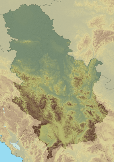 Zlatibor Location in Serbia | |
| Location | Western Serbia |
| Parent range | Dinaric Alps |
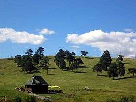
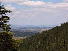
Zlatibor (Serbian Cyrillic: Златибoр pronounced [zlǎtibɔːr]) is a mountainous region situated in the western part of Serbia.
Zlatibor is an important tourist area of Serbia, with resources for health tourism, skiing and hiking.[1] The main city of the region is Užice, located at the foothills of the mountain, and most of the area belongs to the municipality of Čajetina. Town of Zlatibor emerged from a group of vacation homes into a full-fledged urban location.
Zlatibor is administratively divided into two municipalities within Serbia: Čajetina and Užice, in the Zlatibor District. The railroad Belgrade-Bar passes through Zlatibor.
History
In the Middle Ages, Zlatibor was known as Rujno, a župa that was part of Raška. The name Zlatibor started to be used in the 18th century, but its etymology is uncertain. It probably stems from the Serbian words zlatni (golden) and bor (pine). Pinus sylvestris var. zlatiborica is a subspecies of pine originating from the mountain, and is endangered today. The hill called Cigla near the village of Jablanica still has some borderline markings of the Kingdom of Serbia, Austria-Hungary and the Ottoman Empire.
Geography
Zlatibor is located in the northern part of the Stari Vlah region, a historical border region between Raška, Herzegovina and Bosnia. It spreads over an area of 300 square kilometres (120 square miles), 43 km (27 mi) in length, southeast to northwest, and up to 37 km (23 mi) in width. Its highest peak Tornik has an elevation of 1,496 m. Zlatibor is situated between 43° 31' N, and 43° 51' N, and between 19° 28' E and 19° 56' E.
The southern and the eastern border of Zlatibor are natural – the rivers Uvac and Veliki Rzav. Villages of Mokra Gora, Semegnjevo and Jablanica mark its western border towards the Tara Mountain. Southern part of Zlatibor, extending towards the Zlatar (mountain) mountain, is referred to as Murtenica.[2]
Climate
The climate is humid continental (Köppen climate classification: Dfb).
| Climate data for Zlatibor, 1981-2010 | |||||||||||||
|---|---|---|---|---|---|---|---|---|---|---|---|---|---|
| Month | Jan | Feb | Mar | Apr | May | Jun | Jul | Aug | Sep | Oct | Nov | Dec | Year |
| Average high °C (°F) | 2.1 (35.8) |
3.3 (37.9) |
7.5 (45.5) |
12.4 (54.3) |
17.6 (63.7) |
20.8 (69.4) |
23.1 (73.6) |
23.3 (73.9) |
18.6 (65.5) |
14.0 (57.2) |
7.8 (46) |
2.6 (36.7) |
12.8 (55) |
| Daily mean °C (°F) | −2.1 (28.2) |
−1.3 (29.7) |
2.4 (36.3) |
7.2 (45) |
12.3 (54.1) |
15.4 (59.7) |
17.2 (63) |
17.5 (63.5) |
13.1 (55.6) |
8.8 (47.8) |
3.2 (37.8) |
−1.2 (29.8) |
7.7 (45.9) |
| Average low °C (°F) | −5.2 (22.6) |
−4.7 (23.5) |
−1.2 (29.8) |
3.2 (37.8) |
7.9 (46.2) |
10.8 (51.4) |
12.7 (54.9) |
12.9 (55.2) |
9.0 (48.2) |
5.1 (41.2) |
0.1 (32.2) |
−4.0 (24.8) |
3.9 (39) |
| Average precipitation mm (inches) | 65.4 (2.575) |
68.5 (2.697) |
73.4 (2.89) |
79.0 (3.11) |
94.4 (3.717) |
110.2 (4.339) |
96.3 (3.791) |
78.8 (3.102) |
98.3 (3.87) |
78.2 (3.079) |
92.3 (3.634) |
82.6 (3.252) |
1,017.3 (40.051) |
| Source: Republic Hydrometeorological Service of Serbia[3] | |||||||||||||
Tourism
Situated at an elevation of just over 1,000 metres, Zlatibor is a climatic resort, characterized by a cool alpine climate, clean air, long periods of sunshine during the summer and a heavy snow cover in winter. Tourist facilities include modern hotels, holiday centers and cottages, sports grounds and skiing tracks.
Tourist era on Zlatibor officially began on 20 August 1893, when the King of Serbia Aleksandar Obrenović decided to establish a health resort on an initiative from the local hosts. To his honor, a fountain was erected on the place where he had lunch; it was later accompanied by a small lake, titled Kraljeva Voda ("King's water"). In 1945, it was renamed to Partizanske Vode after Yugoslav Partisans, and in 1991 the town received the current name Zlatibor. The area is a location of numerous hotels, villas, restaurants, open swimming pools and other sports facilities. Eventually, residents of surrounding villages of Sirogojno, Gostilje, Jablanica, Rožanstvo, Ljubiš, Tripkova and the town of Čajetina opened their homes to tourists and built other facilities.[1]
Tornik ski resort
Tornik (Serbian Cyrillic: Торник) is the highest peak of Zlatibor, at an altitude 1,496 m (4,908 ft).
Tornik ski resort (Serbian: Ски центар Торник / Ski centar Tornik)[4] is located at elevations between 1,110 and 1,490 m. It has several tracks, four being covered by artificial snowing systems, with the total capacity of the about 5,400 skiers per hour. It is equipped with a six-seater chairlift, carrying 3,000 skiers per hour, and two T-bar ski lifts with total capacity of 2,400 skiers per hour. Along with Kopaonik and Stara Planina, it is one of the most popular resorts in Serbia and western Balkans.
Protection
The process began in January 2016 and in October 2017, the government placed part of the mountain under protection as a Nature Park Zlatibor. The land within the "protected area of exceptional importance" (IUCN Category I) is 56% privately owned and covers the villages of Semegnjevo, Jablanica, Stublo, Dobroselica, Ljubiš and Gostilje. The settled area is in the lowest, third level of protection while the first level of protection occupies 4,69% of the entire area, or 1,968.89 ha (4,865.2 acres). Within the park there are four regions: Viogor, Black Rzav, Uvac Gorge and Griža Gorge. There are also previously protected areas: strict natural reserve "Park Forest" (12.54 ha (31.0 acres)) and natural monuments "Lira black pine" (near Nova Varoš) and "Three black pines - Dobroselica" (near Čajetina).[5] The total area of the park is 41.923 ha (103.59 acres).[6]
There are 1,044 species of plants in the park. The prevailing fauna consists of the autochthonous black pine forests and the mixed forests of black and Scots pine, which are categorized as a priority habitats by the Natura 2000. There are 18 species of amphibians and reptiles, 154 species of birds (42% of all bird species recorded in Serbia) and 38 species of mammals (40%). The park includes three cultural monuments and numerous objects of architectural legacy.[5]
The park is bounded by the Uvac river on the south, border with Bosnia and Herzegovina on the west, mountains of Mokra Gora, Semegnjevo and Grude on the north and the mountain of Murtenica and Katušnica river on the east. Ribnica Lake and Čigota massif are within the park, while the towns of Čajetina and Zlatibor remain outside.[6]
See also
- Ponikve Airport (nearby airport)
References
- 1 2 "Zlatibor Pride Anniversary - 120 Years of Tourism". Tourist Organization of Zlatibor. Retrieved 2016-01-19.
- ↑ Olga Savić. "Geografske odlike Užičkog područja: Reljef" (PDF) (in Serbian). Grad Užice. Retrieved 2016-01-19.
- ↑ "SREDNJE MESEČNE, GODIŠNJE I EKSTREMNE VREDNOSTI 1981 - 2010". October 2017.
- ↑ "Ski centar Tornik". Ski Resorts of Serbia. Retrieved 2016-01-19.
- 1 2 Slavica Stuparušić (16 October 2017), "Još dva parka prirode na mapi Srbije" [Two more nature parks on the map of Serbia], Politika (in Serbian), p. 08
- 1 2 Branko Pejović (19 October 2017), "Park prirode „Zlatibor" neće zaustaviti gradnju gondola" [Nature Park Zlatibor will not stop the construction of the cable car], Politika (in Serbian), pp. 01 & 16
External links
| Wikivoyage has a travel guide for Zlatibor. |
| Wikimedia Commons has media related to Zlatibor. |
|  | |
(*) indicates location within Kosovo | ||