Mount Hobson (Auckland)
| Ōhinerau | |
|---|---|
| Mount Hobson | |
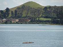
 Ōhinerau / Mount Hobson as viewed from One Tree Hill. | |
| Highest point | |
| Elevation | 143 m (469 ft) |
| Coordinates | 36°52′40″S 174°47′10″E / 36.877814°S 174.786156°ECoordinates: 36°52′40″S 174°47′10″E / 36.877814°S 174.786156°E |
| Geography | |
| Location | North Island, New Zealand |
| Geology | |
| Volcanic arc/belt | Auckland volcanic field |
Ōhinerau / Mount Hobson (also known as Ōhinerangi and Remuwera) is a 143 m high volcanic cone in the Auckland volcanic field in Auckland, New Zealand.
Located in the Remuera suburb, to the east of the Newmarket commercial suburb, it has been extensively modified by human use, first by Māori for use as a pā and later by use as quarry and pasture land before finally having a water reservoir installed in its cone to supply the surrounding area. An additional, partially buried, water reservoir was built on the low southern side of the mountain in 1955. English oaks and pōhutukawa are the most common trees on the hill.[1]
Ōhinerau is named after Hinerau, a goddess of whirlwinds.[2] Mount Hobson is named after Captain William Hobson. Remuwera was originally the name of a pa site on the hill that was also utilised for kumara and food gardens.[3] The name Remuwera means the burnt edge of a flax garment.[4]
In the 2014 Treaty of Waitangi settlement with the Tamaki Makaurau Collective of 13 Auckland iwi, the volcano was officially named Ōhinerau / Mount Hobson and ownership was vested to the collective. It is now co-governed by the collective and Auckland Council in common benefit of the iwi "and all other people of Auckland".[5][6][7][8][9][10]
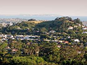
 View northwestwards over Auckland City from the top of the mountain.
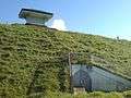 Showing the water reservoir installations at the top of the mountain.
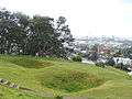 Kumara pits from when the hill was a Māori pā .
References
- ↑ Cameron, Ewen; Hayward, Bruce; Murdoch, Graeme (2008). A field guide to Auckland. Random House. p. 212. ISBN 978-1-86962-151-3.
- ↑ Reed, A.W. (1996). The Reed Dictionary of Maori Place Names (Third ed.). Reed Publishing. p. 67. ISBN 0-7900-0040-7.
- ↑ "NGĀ MANA WHENUA O TĀMAKI MAKAURAU and THE CROWN: NGĀ MANA WHENUA O TĀMAKI MAKAURAU COLLECTIVE REDRESS DEED: DOCUMENTS" (PDF). Retrieved 25 October 2014.
- ↑ Reed, A.W. (1996). The Reed Dictionary of Maori Place Names (Third ed.). Reed Publishing. p. 97. ISBN 0-7900-0040-7.
- ↑ Dearnaley, Mathew (27 September 2014). "Volcanic cones regain Maori names". New Zealand Herald. Retrieved 25 October 2014.
- ↑ "Ngā Mana Whenua o Tāmaki Makaurau Collective Redress Act 2014". New Zealand Legislation. Retrieved 25 October 2014.
- ↑ "Ngā Mana Whenua o Tāmaki Makaurau Collective Redress Act 2014 registration guideline" (PDF). Land Information New Zealand. Archived from the original (PDF) on 29 October 2014. Retrieved 25 October 2014.
- ↑ "NZGB decisions - September 2014". Land Information New Zealand. Archived from the original on 29 October 2014. Retrieved 25 October 2014.
- ↑ "Protection of tupuna maunga assured under ownership transfer". Auckland Council. Retrieved 25 October 2014.
- ↑ "New governance structure for treasured tūpuna maunga". Auckland Council. Retrieved 25 October 2014.
External links
- Photographs of Ōhinerau held in Auckland Libraries' heritage collections.