Mount Zeil
| Mount Zeil | |
|---|---|
| Urlatherrke | |
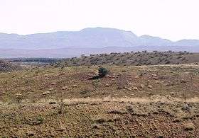 Mount Zeil viewed from the south | |
| Highest point | |
| Elevation | 1,531 m (5,023 ft) AHD |
| Coordinates | 23°22′59″S 132°22′59″E / 23.38306°S 132.38306°ECoordinates: 23°22′59″S 132°22′59″E / 23.38306°S 132.38306°E |
| Geography | |
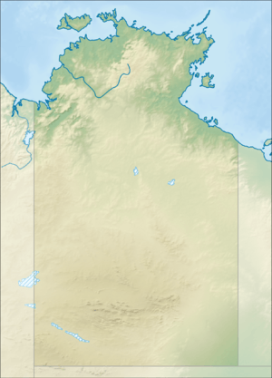 Mount Zeil Location of Mount Zeil in the Northern Territory | |
| Location | Northern Territory, Australia |
| Parent range | MacDonnell Ranges |
Mount Zeil (1,531 m or 5,023 ft)[1] is a mountain situated in the western MacDonnell Ranges in Australia's Northern Territory. It is the highest peak in the Northern Territory, and the highest peak on the Australian mainland west of the Great Dividing Range.
History
It is believed that Mount Zeil was named during or following Ernest Giles '1872 expedition, probably after Count Zeil, who had recently distinguished himself with geographic explorations in Spitzbergen; a footnote in Giles' published journal implies that the naming was instigated by his benefactor, Baron Ferdinand von Mueller.[2]
Aboriginal naming
The indigenous name for Mount Zeil in the Western Arrernte language is Urlatherrke, referring to the Yeperenye caterpillars.[3]
See also
References
- ↑ "Mount Zeil". Gazetteer of Australia online. Geoscience Australia, Australian Government.
- ↑ Northern Territory Place Names Register. Retrieved 1 October 2007
- ↑ hermannsburgschool.com. Retrieved 4 January 2007
External links
|  | |
| ||
This article is issued from
Wikipedia.
The text is licensed under Creative Commons - Attribution - Sharealike.
Additional terms may apply for the media files.