Monte Poro Lighthouse
 Monte Poro Lighthouse | |
 Monte Poro Tuscany  Monte Poro Monte Poro (Italy) | |
| Location |
Marina di Campo Elba Italy |
|---|---|
| Coordinates | 42°43′40″N 10°14′15″E / 42.727822°N 10.237489°ECoordinates: 42°43′40″N 10°14′15″E / 42.727822°N 10.237489°E |
| Year first constructed | 1968 |
| Foundation | concrete base |
| Construction | concrete tower |
| Tower shape | cylindrical tower with lantern |
| Markings / pattern | white tower, grey metallic lantern roof |
| Height | 2 metres (6.6 ft) |
| Focal height | 160 metres (520 ft) |
| Current lens |
Type OF 375 Focal length: 187,5 mm |
| Light source | mains power |
| Intensity | MaxiHalo-60 EFF |
| Range |
main: 16 nautical miles (30 km; 18 mi) reserve: 12 nautical miles (22 km; 14 mi) |
| Characteristic | Fl W 5s. |
| Fog signal | no |
| Admiralty number | E1438 |
| NGA number | 8952 |
| ARLHS number | ITA-295 |
| Italy number | 2054 E.F. |
| Managing agent | Arcipelago Toscano National Park[1][2] |
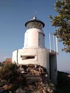
Monte Poro Lighthouse (Italian: Faro di Monte Poro) is an active lighthouse located on the summit of Monte Poro, in the south western part of Elba on the Tyrrhenian Sea, a region covered by Macchia Mediterranea. The place was of some strategic interest during World War II because close to the lighthouse are the ruins of a German position.
Description
The lighthouse, built in 1968, consists of a cylindrical squat tower, 2 metres (6.6 ft) high, with lantern. The tower is mounted on a cylindrical equipment building similar to a pillbox because provided with a stepped embrasure. The equipment building and the tower are white, the lantern roof is grey metallic.
The light is positioned at 160 metres (520 ft) above sea level and emits a white flash in a 5 seconds period, visible up to a distance of 16 nautical miles (30 km; 18 mi). The lighthouse is completely automated and managed by the Arcipelago Toscano National Park with the identification code number 2054 E.F.[2][3]
See also
References
- ↑ "Lighthouses of Italy: Toscana". The Lighthouse Directory. Retrieved June 2, 2018.
- 1 2 "Monte Poro". Marina Militare. Retrieved June 2, 2018.
- ↑ "Mappa dei fari Italiani". ARI Genova. Retrieved June 2, 2018.
External links
| Wikimedia Commons has media related to Monte Poro Lighthouse. |